Barwon Heads VIC 3227
2,977 addresses · 88 streets
Corangamite Electorate › Greater Geelong LGA › Barwon Heads · 66 km from Melbourne
📦 Thinking of moving here? Read the Barwon Heads moving guide

Living Here
Barwon Heads is a suburb of Victoria, home to about 4,353 people, with a median age of 46. The typical household earns around $2,226 a week, with median rent near $450 a week. Most homes are houses. About 83% of households own their home and 16% rent. Most workers drive to work. Common community backgrounds include English, Australian, Irish. On the ABS socio-economic scale it sits in decile 10 of 10 nationally — a relatively advantaged area. The median house sells for about $1,463,000.
Over time — Census 2001 → 2021
Dashed line: district figures for the Ocean Grove - Barwon Heads statistical area (SA2), the smallest area the ABS published before 2011. Solid line: Barwon Heads itself.
Getting Around & Local Services
1 supermarket
2 beaches
1 pharmacy
2 doctors & medical clinics
2 dentists
2 hospitals
1 library
2 post offices
1 gym
1 hardware store
2 hairdressers
2 beauty salons
1 mechanic
Getting around. Airport: Avalon Airport, 26.7 km north.
Sport & Recreation
7 facilities recorded in Barwon Heads.
- Barwon Bliss Mind Body Fit Fitness / Gymnasium Workouts
- Barwon Heads Boxing and Fitness Boxing, Fitness / Gymnasium Workouts
- Barwon Heads Golf Club Golf
- Barwon Heads Village Park Australian Rules Football, Cricket, Equestrian, Soccer, Tennis (Outdoor)
- Barwon Heads Village Park Athletics, Equestrian, Lawn Bowls
- Barwon Heads/13th Beach Surf Life Saving
- C-Change Training Studio Fitness / Gymnasium Workouts
Socio-economic Standing
Deciles from 1 (lowest) to 10 (highest), against all Australian suburbs. The overall figure weighs advantage and disadvantage together; economic resources counts income and housing, and education & jobs counts qualifications and occupation. They often differ. Source: ABS SEIFA 2021.
Median Sale Prices
Median of recorded sales in the period, not a valuation. Source: Victorian Property Sales Report, Land Use Victoria.
Tree cover
🌳 Tree canopy: 16.1% share of land under canopy · satellite map, 2020
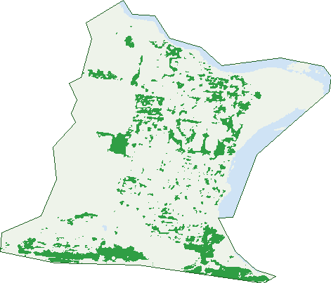
Green: 10 m cells where trees dominate, satellite 2021. Blue: water. The line is the suburb boundary.
| Canopy share, 1 m canopy height map, 2020 | 16.1% |
|---|---|
| Land with trees, 10 m satellite map, 2021 | 13.2% |
Demographics
Unemployment 2.7% · Labour-force participation 58.3%
Population by age in Barwon Heads
| 0-4 | 159 |
|---|---|
| 5-14 | 709 |
| 15-19 | 278 |
| 20-24 | 138 |
| 25-34 | 241 |
| 35-44 | 530 |
| 45-54 | 663 |
| 55-64 | 606 |
| 65-74 | 650 |
| 75-84 | 285 |
| 85+ | 95 |
Dwelling types in Barwon Heads
| House | 1,416 |
|---|---|
| Townhouse | 94 |
| Apartment | 44 |
| Other | 3 |
Households by weekly income in Barwon Heads
| <$650 | 181 |
|---|---|
| $650-1,499 | 313 |
| $1,500-2,999 | 402 |
| $3,000+ | 528 |
Top ancestries in Barwon Heads
| English | 1,936 |
|---|---|
| Australian | 1,727 |
| Irish | 748 |
| Scottish | 692 |
| Ancestry NS | 289 |
| Other | 240 |
Housing tenure in Barwon Heads
| Owned | 739 |
|---|---|
| Mortgage | 527 |
| Rented | 241 |
| Other | 27 |
Cars per household in Barwon Heads
| 0 | 31 |
|---|---|
| 1 | 449 |
| 2 | 753 |
| 3 | 217 |
| 4+ | 77 |
Commute to work in Barwon Heads
| Car | 984 |
|---|---|
| Train | 4 |
| Bus | 3 |
| Tram/ferry | 0 |
| Walked | 42 |
| Bicycle | 31 |
| Home | 604 |
Top countries of birth in Barwon Heads
| England | 183 |
|---|---|
| New Zealand | 31 |
| United States | 25 |
| Scotland | 22 |
| South Africa | 19 |
| Netherlands | 16 |
Languages used at home in Barwon Heads
| Italian | 11 |
|---|---|
| Greek | 7 |
| Japanese | 6 |
| Croatian | 4 |
| Russian | 4 |
Birds & Wildlife Nearby
98,296 bird observations recorded near Barwon Heads — most often seen:
- Red Wattlebird (5,618)
- Little Raven (5,447)
- Eastern Rosella (4,596)
- Rainbow Lorikeet (4,360)
- Noisy Miner (4,319)
- Silver Gull (4,093)
- Common Starling (4,082)
- Magpie-lark (3,912)
- Australian Magpie (3,805)
- Welcome Swallow (3,665)
- New Holland Honeyeater (3,663)
- Superb Fairy-wren (3,501)
- Grey Butcherbird (3,388)
Show all 30 birds recorded near Barwon Heads
- Galah (3,238)
- Southern Victoria Australian Magpie (3,136)
- Australian White Ibis (3,130)
- Little Pied Cormorant (2,899)
- Pacific Black Duck (2,866)
- White-faced Heron (2,692)
- Eurasian Blackbird (2,630)
- Chestnut Teal (2,555)
- Brown Thornbill (2,547)
- Masked Lapwing (2,450)
- Australian Pelican (2,409)
- Sulphur-crested Cockatoo (2,404)
- Spotted Turtle-dove (2,398)
- Willie Wagtail (2,303)
- Royal Spoonbill (2,084)
- Pied Currawong (2,083)
- Black Swan (2,023)
Sightings reported by observers, not a survey, so the counts show what people record rather than what lives here. Source: Atlas of Living Australia.
Nearby Suburbs
The closest suburbs to Barwon Heads:
- Ocean Grove (4.3 km)
- Connewarre (4.5 km)
- Wallington (6.5 km)
- Marcus Hill (7.8 km)
- Breamlea (8.6 km)
- Leopold (9.8 km)
- Point Lonsdale (10.6 km)
- Mannerim (11.6 km)
Embed this suburb
Add this free Barwon Heads stat card to your own site — just copy the code:
Preview:
Cite this page
Quoting these figures? Copy the credit line:
Keep an eye on Barwon Heads
One email when this data meaningfully changes — new census figures, prices, rankings. No spam, unsubscribe anytime.
Streets
- Affleck Court (15)
- Aitken Street (2)
- Araluen Court (17)
- Barnett Close (8)
- Barwon Heads Road (5)
- Barwon Terrace (17)
- Baytown Close (12)
- Bell Street (12)
- Black Swan Court (13)
- Bostock Avenue (18)
- Bridge Road (68)
- Campbell Street (29)
- Carr Street (132)
- Challis Street (8)
- Chanticleer Place (12)
- Clifford Parade (28)
- Colite Street (9)
- Coogee Court (24)
- Corymbia Circuit (50)
- Cosham Court (12)
- Cottesloe Drive (63)
- Cronulla Court (23)
- Culdee Court (12)
- Curlew Court (8)
- Dudley Court (21)
- Eddystone Court (34)
- Ewing Blyth Drive (23)
- Fishermans Walk (13)
- Flinders Parade (45)
- Furneaux Close (24)
- Galveston Court (14)
- Geelong Road (73)
- Geelong Road E (8)
- George Street (37)
- Glyndon Court (20)
- Golf Links Road (116)
- Golightly Street (22)
- Grandview Parade (39)
- Grove Road (76)
- Hampden Close (10)
- Haynes Court (8)
- Henley Street (23)
- Heron Crescent (30)
- Hitchcock Avenue (279)
- Hogan Drive (30)
- Hopgood Place (34)
- Humble Street (19)
- Ibis Court (6)
- Jasper Avenue (25)
- Jetty Road (1)
- Knox Drive (68)
- Lawrenny Court (16)
- Margate Street (63)
- Memorial Lane (8)
- Midden Terrace (38)
- Minah Street (10)
- Mooroopna Court (13)
- Mulgoa Court (26)
- Newbay Close (55)
- Noble Street (54)
- Ozone Road (53)
- Paringa Lane (4)
- Pelican Court (11)
- Plover Court (8)
- Punt Road (35)
- Ramsgate Street (5)
- Reid Street (50)
- River Parade (44)
- Riverside Lane (4)
- Riverside Terrace (37)
- Saratoga Avenue (40)
- Seabank Drive (81)
- Seaview Avenue (53)
- Selby Close (6)
- Sheepwash Road (126)
- Snead Street (1)
- Stephens Parade (37)
- Taits Road (125)
- Talbot Street (8)
- The Mews (6)
- Thirteenth Beach Road (1)
- Thomson Drive (51)
- Thorn Street (47)
- Tremont Court (32)
- Von Nida Avenue (26)
- Wandin Court (17)
- Warrenbeen Court (23)
- Wattle Bird Crescent (68)