Balwyn VIC 3103
7,708 addresses · 152 streets
Kooyong Electorate › Boroondara LGA › Balwyn · 11 km from Melbourne
📦 Thinking of moving here? Read the Balwyn moving guide

Living Here
Balwyn is a suburb of Victoria, home to about 13,495 people, with a median age of 43. The typical household earns around $1,975 a week, with median rent near $451 a week. Most homes are houses. About 70% of households own their home and 27% rent. Most workers drive to work. Common community backgrounds include Chinese, English, Australian. On the ABS socio-economic scale it sits in decile 10 of 10 nationally — a relatively advantaged area. The median house sells for about $2,868,000.
Over time — Census 2001 → 2021
Dashed line: district figures for the Balwyn statistical area (SA2), the smallest area the ABS published before 2011. Solid line: Balwyn itself.
Getting Around & Local Services
13 childcare & kindergartens
1 playground
1 dog park
1 carpenter
Getting around. Train station: Canterbury, 1.7 km south · Tram stop: Stop 47: Balwyn Road, 400 m south · Railway halt: Box Hill, 3.2 km east · Bus interchange: Bulleen Park and Ride, 3.4 km north · Ferry wharf: Como Landing, 7.4 km west · Airport: Essendon Fields Airport, 18.6 km north-west.
Sport & Recreation
2 facilities recorded in Balwyn.
- Balwyn Park Australian Rules Football, Cricket, Tennis (Outdoor)
- Boroondara Sports Complex Aerobics, Basketball, Fitness / Gymnasium Workouts, Netball (Indoor), Soccer (Indoor Soccer / Futsal), Swimming
Socio-economic Standing
Deciles from 1 (lowest) to 10 (highest), against all Australian suburbs. The overall figure weighs advantage and disadvantage together; economic resources counts income and housing, and education & jobs counts qualifications and occupation. They often differ. Source: ABS SEIFA 2021.
Median Sale Prices
Median of recorded sales in the period, not a valuation. Source: Victorian Property Sales Report, Land Use Victoria.
Tree cover
🌳 Tree canopy: 13% share of land under canopy · satellite map, 2020
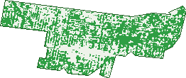
Green: 10 m cells where trees dominate, satellite 2021. Blue: water. The line is the suburb boundary.
| Canopy share, 1 m canopy height map, 2020 | 13.0% |
|---|---|
| Land with trees, 10 m satellite map, 2021 | 57.5% |
Demographics
Unemployment 5% · Labour-force participation 57.7%
Population by age in Balwyn
| 0-4 | 454 |
|---|---|
| 5-14 | 1,730 |
| 15-19 | 945 |
| 20-24 | 900 |
| 25-34 | 1,348 |
| 35-44 | 1,678 |
| 45-54 | 1,915 |
| 55-64 | 1,676 |
| 65-74 | 1,404 |
| 75-84 | 937 |
| 85+ | 509 |
Dwelling types in Balwyn
| House | 2,977 |
|---|---|
| Townhouse | 1,320 |
| Apartment | 768 |
| Other | 4 |
Households by weekly income in Balwyn
| <$650 | 796 |
|---|---|
| $650-1,499 | 1,105 |
| $1,500-2,999 | 1,256 |
| $3,000+ | 1,592 |
Top ancestries in Balwyn
| Chinese | 4,640 |
|---|---|
| English | 2,850 |
| Australian | 2,273 |
| Other | 1,475 |
| Irish | 1,142 |
| Scottish | 896 |
Housing tenure in Balwyn
| Owned | 2,145 |
|---|---|
| Mortgage | 1,376 |
| Rented | 1,356 |
| Other | 148 |
Cars per household in Balwyn
| 0 | 358 |
|---|---|
| 1 | 2,027 |
| 2 | 1,941 |
| 3 | 493 |
| 4+ | 217 |
Commute to work in Balwyn
| Car | 2,596 |
|---|---|
| Train | 74 |
| Bus | 52 |
| Tram/ferry | 87 |
| Walked | 128 |
| Bicycle | 21 |
| Home | 2,358 |
Top countries of birth in Balwyn
| China | 2,325 |
|---|---|
| India | 491 |
| Malaysia | 450 |
| England | 321 |
| Hong Kong | 282 |
| Vietnam | 196 |
Languages used at home in Balwyn
| Mandarin | 2,961 |
|---|---|
| Cantonese | 897 |
| Greek | 344 |
| Vietnamese | 197 |
| Hindi | 191 |
| Italian | 170 |
Birds & Wildlife Nearby
125,052 bird observations recorded near Balwyn — most often seen:
- Little Raven (7,715)
- Rainbow Lorikeet (7,653)
- Noisy Miner (7,113)
- Australian Magpie (6,825)
- Common Myna (6,588)
- Pacific Black Duck (6,519)
- Red Wattlebird (5,689)
- Magpie-lark (5,443)
- Dusky Moorhen (4,906)
- Eurasian Blackbird (4,811)
- Pied Currawong (4,299)
- Spotted Turtle-dove (4,213)
- Grey Butcherbird (4,190)
Show all 30 birds recorded near Balwyn
- Southern Victoria Australian Magpie (3,933)
- Brown Thornbill (3,926)
- Australian Wood Duck (3,506)
- Chestnut Teal (3,307)
- Superb Fairy-wren (3,247)
- White-browed Scrubwren (3,077)
- Eastern Rainbow Lorikeet (2,928)
- Eastern Rosella (2,823)
- Australasian Purple Swamphen (2,765)
- Welcome Swallow (2,749)
- Grey Fantail (2,656)
- Southern Noisy Miner (2,646)
- Rock Dove (2,381)
- Little Pied Cormorant (2,345)
- Laughing Kookaburra (2,308)
- Bell Miner (2,297)
- Galah (2,194)
Sightings reported by observers, not a survey, so the counts show what people record rather than what lives here. Source: Atlas of Living Australia.
Nearby Suburbs
The closest suburbs to Balwyn:
- Deepdene (1.5 km)
- Canterbury (1.7 km)
- Balwyn North (1.8 km)
- Surrey Hills (2.3 km)
- Mont Albert (2.4 km)
- Mont Albert North (2.5 km)
- Kew East (3.1 km)
- Camberwell (3.4 km)
Embed this suburb
Add this free Balwyn stat card to your own site — just copy the code:
Preview:
Cite this page
Quoting these figures? Copy the credit line:
Keep an eye on Balwyn
One email when this data meaningfully changes — new census figures, prices, rankings. No spam, unsubscribe anytime.
Streets
- Aif Street (9)
- Alandale Avenue (20)
- Austin Street (42)
- Balwyn Road (251)
- Banff Court (3)
- Banool Road (147)
- Beckett Street (27)
- Belgrove Avenue (66)
- Belmore Road (366)
- Bernborough Avenue (27)
- Bevan Street (54)
- Birdwood Street (76)
- Birtles Court (12)
- Birtles Street (11)
- Boston Road (64)
- Bowley Avenue (11)
- Brenbeal Street (117)
- Bruce Street (37)
- Burke Road (57)
- Burroughs Road (48)
- Canyon Street (10)
- Caravan Street (26)
- Carmel Court (7)
- Carrigal Street (29)
- Carronshore Close (8)
- Chatfield Avenue (6)
- Cherry Road (35)
- Clapham Street (50)
- Clayton Road (22)
- Collins Court (19)
- Connell Court (6)
- Conway Crescent (26)
- Cremorne Street (33)
- Crom Street (8)
- Dee Street (6)
- Delfi Court (8)
- Dundee Street (13)
- Dunure Court (8)
- Edmond Street (6)
- Ellen Street (25)
- Elliott Avenue (72)
- Erne Street (22)
- Eton Court (3)
- Evelina Street (28)
- Evergreen Avenue (2)
- Eyre Street (33)
- Fitzgerald Street (69)
- Frederick Street (52)
- Freeman Street (29)
- Georgian Court (10)
- Glenluss Street (15)
- Gordon Street (160)
- Grant Avenue (9)
- Grey Street (57)
- Grosvenor Parade (57)
- Hamilton Street (8)
- Hardwicke Street (21)
- Head Street (50)
- Hender Court (5)
- Henley Street (23)
- Henry Street (25)
- Hertford Crescent (33)
- Highland Avenue (19)
- Hilary Court (3)
- Hilda Street (52)
- Ian Street (8)
- Iramoo Street (41)
- Jersey Street (52)
- John Street (37)
- Jurang Street (107)
- Kaarumba Grove (12)
- Kaleno View (27)
- Kalgurli Court (6)
- Kalimna Street (44)
- Kenilworth Street (23)
- Kerry Parade (13)
- King Street (78)
- Kinsale Crescent (7)
- Kireep Road (214)
- Knutsford Street (40)
- Liboria Street (4)
- Linckens Crescent (31)
- Lynch Court (4)
- Madang Avenue (17)
- Maleela Avenue (111)
- Mangan Street (70)
- Marion Avenue (3)
- Maritana Court (4)
- Marock Place (6)
- Marong Grove (9)
- Melba Court (5)
- Metung Street (86)
- Millah Road (10)
- Monash Avenue (82)
- Mont Albert Road (8)
- Myambert Avenue (11)
- Naroo Street (41)
- Narrak Road (82)
- Norbert Street (44)
- Northcote Avenue (146)
- Nott Street (43)
- Nungerner Street (91)
- Oakdale Avenue (11)
- Paisley Street (22)
- Palmer Avenue (20)
- Para Street (16)
- Parkdale Avenue (25)
- Parring Road (123)
- Pembroke Road (13)
- Percy Street (55)
- Porter Road (34)
- Power Street (69)
- Prowse Avenue (6)
- Pryton Court (18)
- Raynes Street (50)
- Reid Street (31)
- Relowe Crescent (61)
- Reumah Court (7)
- Rochester Road (90)
- Rogerson Court (8)
- Ropley Avenue (24)
- Ruby Street (67)
- Ruhbank Avenue (9)
- Salford Avenue (13)
- Salisbury Street (21)
- Sanctuary Close (3)
- Sevenoaks Street (42)
- Shrimpton Court (7)
- Strabane Avenue (49)
- Stroud Street (83)
- Talbot Avenue (109)
- Tedstone Crescent (7)
- Threadneedle Street (68)
- Tivey Parade (23)
- Tonkin Avenue (23)
- Union Road (128)
- Vauxhall Road (27)
- Walker Street (7)
- Wallace Street (11)
- Weir Street (195)
- Westminster Street (53)
- Weston Street (12)
- Whitehorse Road (1,011)
- Wills Street (49)
- Winmalee Road (169)
- Woods Street (19)
- Wynette Avenue (15)
- Yandilla Street (27)
- Yarrbat Avenue (218)
- Yerrin Street (208)
- Yonga Road (24)
- Yongala Street (58)