Anglesea VIC 3230
4,345 addresses · 115 streets
Wannon Electorate › Surf Coast LGA › Anglesea · 95 km from Melbourne
📦 Thinking of moving here? Read the Anglesea moving guide

Living Here
Anglesea is a suburb of Victoria, home to about 3,208 people, with a median age of 54. The typical household earns around $1,701 a week, with median rent near $405 a week. Most homes are houses. About 79% of households own their home and 18% rent. Most workers drive to work. Common community backgrounds include English, Australian, Irish. On the ABS socio-economic scale it sits in decile 9 of 10 nationally — a relatively advantaged area. The median house sells for about $1,460,000.
Over time — Census 2001 → 2021
Dashed line: district figures for the Lorne - Anglesea statistical area (SA2), the smallest area the ABS published before 2011. Solid line: Anglesea itself.
Getting Around & Local Services
1 school
1 supermarket
1 park
1 pharmacy
1 post office
1 service station
2 gyms & sports centres
1 golf club
2 bakeries
Getting around. Airport: Colac Airport, 45.8 km west.
Sport & Recreation
9 facilities recorded in Anglesea.
- Anglesea & District Riding Club Equestrian
- Anglesea Bike Park BMX
- Anglesea Bike Park Cycling
- Anglesea Bowls Club Lawn Bowls
- Anglesea Golf Club Golf
- Anglesea Motor Yacht Club Sailing
- Anglesea Surf Life Saving Club Surf Life Saving
- Anglesea Tennis Club Tennis (Outdoor)
- Ellimatta Reserve Australian Rules Football, Cricket, Netball
Socio-economic Standing
Deciles from 1 (lowest) to 10 (highest), against all Australian suburbs. The overall figure weighs advantage and disadvantage together; economic resources counts income and housing, and education & jobs counts qualifications and occupation. They often differ. Source: ABS SEIFA 2021.
Median Sale Prices
Median of recorded sales in the period, not a valuation. Source: Victorian Property Sales Report, Land Use Victoria.
Tree cover
🌳 Tree canopy: 69.6% share of land under canopy · satellite map, 2020
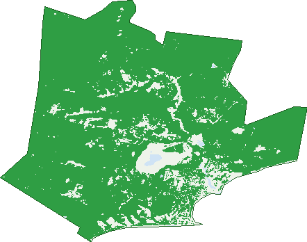
Green: 10 m cells where trees dominate, satellite 2021. Blue: water. The line is the suburb boundary.
| Canopy share, 1 m canopy height map, 2020 | 69.6% |
|---|---|
| Land with trees, 10 m satellite map, 2021 | 88.5% |
Demographics
Unemployment 3.2% · Labour-force participation 54.8%
Population by age in Anglesea
| 0-4 | 161 |
|---|---|
| 5-14 | 298 |
| 15-19 | 122 |
| 20-24 | 104 |
| 25-34 | 254 |
| 35-44 | 333 |
| 45-54 | 361 |
| 55-64 | 543 |
| 65-74 | 613 |
| 75-84 | 306 |
| 85+ | 102 |
Dwelling types in Anglesea
| House | 1,156 |
|---|---|
| Townhouse | 81 |
| Apartment | 6 |
| Other | 8 |
Households by weekly income in Anglesea
| <$650 | 191 |
|---|---|
| $650-1,499 | 333 |
| $1,500-2,999 | 355 |
| $3,000+ | 286 |
Top ancestries in Anglesea
| English | 1,388 |
|---|---|
| Australian | 1,262 |
| Irish | 574 |
| Scottish | 499 |
| Ancestry NS | 201 |
| Other | 161 |
Housing tenure in Anglesea
| Owned | 637 |
|---|---|
| Mortgage | 323 |
| Rented | 219 |
| Other | 40 |
Cars per household in Anglesea
| 0 | 37 |
|---|---|
| 1 | 413 |
| 2 | 576 |
| 3 | 149 |
| 4+ | 58 |
Commute to work in Anglesea
| Car | 711 |
|---|---|
| Train | 4 |
| Bus | 0 |
| Tram/ferry | 0 |
| Walked | 50 |
| Bicycle | 14 |
| Home | 441 |
Top countries of birth in Anglesea
| England | 88 |
|---|---|
| New Zealand | 31 |
| Germany | 22 |
| Ireland | 22 |
| Netherlands | 17 |
| Scotland | 16 |
Languages used at home in Anglesea
| French | 15 |
|---|---|
| Spanish | 14 |
| Italian | 13 |
| Greek | 7 |
| German | 6 |
| Russian | 6 |
Birds & Wildlife Nearby
61,227 bird observations recorded near Anglesea — most often seen:
- Superb Fairy-wren (4,175)
- Red Wattlebird (3,808)
- New Holland Honeyeater (3,420)
- Welcome Swallow (3,251)
- Sulphur-crested Cockatoo (3,026)
- White-eared Honeyeater (2,812)
- Brown Thornbill (2,770)
- Little Raven (2,708)
- Australian Magpie (2,658)
- Grey Fantail (2,429)
- Pied Currawong (2,406)
- Crimson Rosella (2,392)
- Grey Shrike-thrush (2,221)
Show all 30 birds recorded near Anglesea
- Silvereye (1,791)
- Pacific Black Duck (1,708)
- White-browed Scrubwren (1,652)
- Spotted Pardalote (1,515)
- Silver Gull (1,491)
- Laughing Kookaburra (1,487)
- Eastern Spinebill (1,425)
- Eastern Yellow Robin (1,327)
- Australian Wood Duck (1,290)
- Southern Emu-wren (1,290)
- Galah (1,246)
- Blue-winged Parrot (1,187)
- Masked Lapwing (1,172)
- Yellow-tailed Black-cockatoo (1,162)
- Great Cormorant (1,161)
- White-naped Honeyeater (1,128)
- Grey Currawong (1,119)
Sightings reported by observers, not a survey, so the counts show what people record rather than what lives here. Source: Atlas of Living Australia.
Nearby Suburbs
The closest suburbs to Anglesea:
- Aireys Inlet (8.3 km)
- Bells Beach (8.3 km)
- Fairhaven (10.3 km)
- Bellbrae (10.8 km)
- Moggs Creek (11.9 km)
- Jan Juc (12.5 km)
- Paraparap (12.6 km)
- Gherang (13.5 km)
Embed this suburb
Add this free Anglesea stat card to your own site — just copy the code:
Preview:
Cite this page
Quoting these figures? Copy the credit line:
Keep an eye on Anglesea
One email when this data meaningfully changes — new census figures, prices, rankings. No spam, unsubscribe anytime.
Streets
- Agnes Lane (2)
- Allen Street (10)
- Almira Street (5)
- Arinya Crescent (28)
- Bachli Court (21)
- Baker Street (11)
- Bannister Avenue (7)
- Belton Street (61)
- Betleigh Street (18)
- Bingley Parade (42)
- Birdie Avenue (28)
- Birkdale Close (15)
- Bogie Court (9)
- Bon Air Avenue (18)
- Brearley Court (10)
- Brentlauren Court (8)
- Bronwyns Court (3)
- Butterworth Crescent (42)
- Cameron Road (616)
- Camp Road (90)
- Carrawe Court (4)
- Charles Street (22)
- Chatswood Drive (48)
- Clairville Street (17)
- Coalmine Road (2)
- Correa Lane (1)
- Craigdarroch Avenue (15)
- Diggers Parade (19)
- Distillery Creek Road (2)
- Donald Avenue (13)
- Eagle Avenue (25)
- Edward Street (10)
- Eighth Avenue (66)
- Eleventh Avenue (59)
- Elizabeth Street (44)
- Ellimatta Road (4)
- Evans Street (30)
- Fairway Drive (41)
- Fernald Avenue (35)
- Fifth Avenue (80)
- First Avenue (13)
- Forest Road (1)
- Forrest Court (7)
- Foster Street (12)
- Fourth Avenue (17)
- Fraser Avenue (100)
- Frederick Street (20)
- Gabba Court (7)
- Gardiner Avenue (13)
- George Street (24)
- Gilbert Street (1)
- Golf Links Road (48)
- Great Ocean Road (333)
- Greeves Street (17)
- Gum Flats Road (2)
- Hallam Grove (5)
- Harvey Street (128)
- Heather Court (3)
- Hedley Street (8)
- Hillcrest Road (36)
- Holding Court (11)
- Holmwood Avenue (27)
- Hyland Court (11)
- Ingram Road (26)
- Inverlochy Street (32)
- Jackson Street (49)
- Kenneth Street (11)
- Lawrencia Way (10)
- Lewis Court (17)
- Little Street (10)
- Lorettas Way (15)
- Lubel Street (24)
- Manna Gum Close (10)
- Mawson Avenue (13)
- Mcconnell Close (27)
- Mcdougall Road (38)
- Mcmahon Avenue (66)
- Mcmillan Street (89)
- Mcrorie Street (29)
- Melba Parade (99)
- Milner Avenue (9)
- Minifie Avenue (31)
- Murch Crescent (4)
- Murray Street (214)
- Niblick Street (57)
- Ninth Avenue (22)
- Noble Street (216)
- Odonohue Road (59)
- Par Street (2)
- Paringa Crescent (19)
- Parker Street (85)
- Paton Street (3)
- Peter Avenue (15)
- Pickworth Drive (37)
- Purnell Street (44)
- Ramsay Street (8)
- River Reserve Road (21)
- Russell Avenue (36)
- Saltwater Place (15)
- Scott Street (10)
- Second Avenue (48)
- Seventh Avenue (72)
- Simmons Court (7)
- Sixth Avenue (35)
- Sparrow Avenue (14)
- Tenth Avenue (39)
- Third Avenue (38)
- Tonge Street (25)
- Twelfth Avenue (5)
- Valda Street (10)
- Walker Street (52)
- Wallis Street (14)
- Weir Street (37)
- Wilkins Street (9)
- Wray Street (43)