Altona VIC 3018
8,197 addresses · 140 streets
Gellibrand Electorate › Hobsons Bay LGA › Altona · 14 km from Melbourne
📦 Thinking of moving here? Read the Altona moving guide

Living Here
Altona is a suburb of Victoria, home to about 11,490 people, with a median age of 42. The typical household earns around $1,826 a week, with median rent near $385 a week. Most homes are houses. About 67% of households own their home and 31% rent. Most workers drive to work. Common community backgrounds include English, Australian, Irish. On the ABS socio-economic scale it sits in decile 9 of 10 nationally — a relatively advantaged area. The median house sells for about $1,170,000.
Over time — Census 2001 → 2021
Dashed line: district figures for the Altona statistical area (SA2), the smallest area the ABS published before 2011. Solid line: Altona itself.
Getting Around & Local Services
2 supermarkets
2 beaches
1 physiotherapist
3 optometrists
4 childcare & kindergartens
1 post office
10 service stations
2 playgrounds
1 dog park
1 bakery
2 butchers
1 hardware store
3 plumbers
Getting around. Train station: Westona, 550 m west · Bus interchange: Laverton Station Bus Interchange, 4.3 km west · Ferry wharf: Gem Pier Ferry Dock, 7.5 km east · Airport: Essendon Fields Airport, 17 km north-east.
Sport & Recreation
12 facilities recorded in Altona, the first 10 below.
- A.H Ford Reserve Cricket
- Altona Bowling Club (Altona Reserve) Lawn Bowls
- Altona Life Saving Club Surf Life Saving
- Altona P-9 School Cricket
- Altona Sports Club Reserve Cricket
- F Rush Reserve Cricket
- G.K Nevitt Athletics Facility Athletics
- J.K Grant Reserve Australian Rules Football, Cricket, Hockey, Tennis (Outdoor)
- Kooringal Golf Club Golf
- Run With Me Fitness Club Altona Fitness / Gymnasium Workouts
Socio-economic Standing
Deciles from 1 (lowest) to 10 (highest), against all Australian suburbs. The overall figure weighs advantage and disadvantage together; economic resources counts income and housing, and education & jobs counts qualifications and occupation. They often differ. Source: ABS SEIFA 2021.
Median Sale Prices
Median of recorded sales in the period, not a valuation. Source: Victorian Property Sales Report, Land Use Victoria.
Tree cover
🌳 Tree canopy: 3.8% share of land under canopy · satellite map, 2020
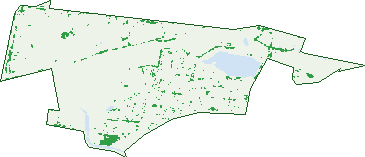
Green: 10 m cells where trees dominate, satellite 2021. Blue: water. The line is the suburb boundary.
| Canopy share, 1 m canopy height map, 2020 | 3.8% |
|---|---|
| Land with trees, 10 m satellite map, 2021 | 3.9% |
Demographics
Unemployment 4.2% · Labour-force participation 62.7%
Population by age in Altona
| 0-4 | 679 |
|---|---|
| 5-14 | 1,331 |
| 15-19 | 472 |
| 20-24 | 447 |
| 25-34 | 1,376 |
| 35-44 | 1,919 |
| 45-54 | 1,683 |
| 55-64 | 1,357 |
| 65-74 | 1,135 |
| 75-84 | 750 |
| 85+ | 345 |
Dwelling types in Altona
| House | 2,933 |
|---|---|
| Townhouse | 1,444 |
| Apartment | 415 |
| Other | 8 |
Households by weekly income in Altona
| <$650 | 871 |
|---|---|
| $650-1,499 | 1,096 |
| $1,500-2,999 | 1,317 |
| $3,000+ | 1,282 |
Top ancestries in Altona
| English | 3,691 |
|---|---|
| Australian | 3,146 |
| Irish | 1,373 |
| Other | 1,372 |
| Scottish | 1,070 |
| Italian | 847 |
Housing tenure in Altona
| Owned | 1,740 |
|---|---|
| Mortgage | 1,447 |
| Rented | 1,489 |
| Other | 74 |
Cars per household in Altona
| 0 | 417 |
|---|---|
| 1 | 2,085 |
| 2 | 1,674 |
| 3 | 394 |
| 4+ | 182 |
Commute to work in Altona
| Car | 2,491 |
|---|---|
| Train | 159 |
| Bus | 25 |
| Tram/ferry | 0 |
| Walked | 89 |
| Bicycle | 51 |
| Home | 2,037 |
Top countries of birth in Altona
| England | 556 |
|---|---|
| New Zealand | 290 |
| Malta | 209 |
| India | 156 |
| China | 134 |
| Vietnam | 124 |
Languages used at home in Altona
| Italian | 179 |
|---|---|
| Greek | 158 |
| Mandarin | 156 |
| Vietnamese | 127 |
| Spanish | 110 |
| Croatian | 103 |
Birds & Wildlife Nearby
235,825 bird observations recorded near Altona — most often seen:
- Common Starling (11,306)
- Black Swan (10,506)
- Silver Gull (10,151)
- Chestnut Teal (10,085)
- Little Pied Cormorant (9,712)
- Little Raven (9,252)
- House Sparrow (9,139)
- Superb Fairy-wren (8,881)
- Magpie-lark (8,617)
- Grey Teal (8,371)
- White-faced Heron (8,306)
- Welcome Swallow (8,152)
- Red Wattlebird (8,061)
Show all 30 birds recorded near Altona
- Common Myna (8,020)
- Eurasian Coot (7,724)
- Australian Pelican (7,644)
- Pacific Black Duck (7,473)
- Spotted Turtle-dove (7,334)
- Australian Magpie (7,300)
- Australian White Ibis (7,298)
- Little Black Cormorant (7,231)
- Willie Wagtail (7,210)
- New Holland Honeyeater (7,062)
- Crested Pigeon (6,462)
- Eurasian Blackbird (6,342)
- Australasian Purple Swamphen (5,865)
- Dusky Moorhen (5,849)
- Hoary-headed Grebe (5,598)
- Royal Spoonbill (5,535)
- Pied Cormorant (5,339)
Sightings reported by observers, not a survey, so the counts show what people record rather than what lives here. Source: Atlas of Living Australia.
Nearby Suburbs
The closest suburbs to Altona:
- Seaholme (2.1 km)
- Altona Meadows (3.9 km)
- Laverton (4.3 km)
- Altona North (4.3 km)
- Williamstown North (4.7 km)
- Laverton North (4.7 km)
- Brooklyn (5.4 km)
- Seabrook (5.7 km)
Embed this suburb
Add this free Altona stat card to your own site — just copy the code:
Preview:
Cite this page
Quoting these figures? Copy the credit line:
Keep an eye on Altona
One email when this data meaningfully changes — new census figures, prices, rankings. No spam, unsubscribe anytime.
Streets
- Aberdeen Road (35)
- Ajax Road (35)
- Akuna Street (19)
- Albury Avenue (33)
- Altona Road (3)
- Aylesbury Drive (51)
- Bayview Street (64)
- Belah Avenue (14)
- Bell Avenue (47)
- Belmar Avenue (49)
- Bent Street (132)
- Bluegum Drive (4)
- Blyth Street (395)
- Boyd Street (39)
- Bracken Grove (105)
- Brook Drive (58)
- Burns Road (26)
- Burt Street (54)
- Cailin Place (24)
- Cain Court (26)
- Campbell Court (14)
- Carruthers Court (14)
- Charles Road (35)
- Chester Road (38)
- Chifley Avenue (62)
- Chorley Avenue (19)
- Civic Parade (366)
- Cobham Street (23)
- Cora Avenue (40)
- Correa Street (5)
- Cowra Street (17)
- Curlew Avenue (76)
- Curtin Court (20)
- Danglow Avenue (21)
- David Street (133)
- Davies Street (102)
- Deavey Court (23)
- Delmont Avenue (24)
- Den Dulk Avenue (19)
- Dove Avenue (70)
- Drake Boulevard (51)
- Dunkley Road (19)
- Edwards Arcade (2)
- Emery Court (17)
- Emu Avenue (47)
- Esplanade (211)
- Federation Court (18)
- Fenfield Street (41)
- Finch Street (14)
- Finley Road (22)
- Fisher Court (22)
- Fleming Street (2)
- Ford Road (9)
- Frazer Avenue (25)
- Fresno Street (20)
- Galvin Street (60)
- Glenwood Avenue (4)
- Government Road (38)
- Green Court (20)
- Greeney Street (8)
- Grieve Parade (340)
- Hammond Street (74)
- Hancock Street (91)
- Harcourt Road (19)
- Harrington Square (43)
- Harrington Street (28)
- Henty Avenue (24)
- Heritage Court (14)
- Iluka Court (6)
- Jordan Close (14)
- Jordon Close (1)
- Karingal Street (23)
- Kearney Avenue (34)
- Keeshan Court (25)
- Kim Court (13)
- Kimpton Way (34)
- Kookaburra Street (52)
- Kororoit Creek Road (26)
- Lark Street (45)
- Lindwood Avenue (17)
- Linnet Street (115)
- Logan Avenue (13)
- Lowe Avenue (48)
- Lugg Street (17)
- Maidstone Street (349)
- Malton Court (9)
- Manning Street (25)
- Mansfield Avenue (39)
- Marshall Court (16)
- Mcalpine Court (25)
- Mcbain Street (98)
- Mcintyre Drive (219)
- Medford Street (17)
- Merlow Street (3)
- Merritt Court (28)
- Milla Way (9)
- Millers Road (78)
- Modal Place (8)
- Morrow Street (4)
- Mount Street (78)
- Mulga Street (76)
- Myrtle Grove (69)
- Newmarket Road (14)
- Park Parade (8)
- Phair Court (18)
- Pier Street (441)
- Pollard Court (20)
- Purnell Street (97)
- Queen Street (408)
- Railway Avenue (1)
- Railway Street N (124)
- Railway Street S (89)
- Rankin Street (21)
- Ransom Avenue (29)
- Rayner Street (180)
- Reserve Court (42)
- Robin Street (42)
- Romawi Street (127)
- Rose Street (207)
- Rosie Place (42)
- Rush Court (15)
- Ryan Lane (2)
- Sargood Street (219)
- Sarros Street (5)
- Scullin Street (23)
- Seagull Avenue (55)
- Seves Street (63)
- Slough Road (56)
- Somers Parade (33)
- Spear Court (25)
- Stanley Street (67)
- Stewart Avenue (165)
- Swallow Street (4)
- Upton Street (132)
- Valletta Lane (6)
- Watson Court (15)
- Webb Street (56)
- Westlink Court (3)
- Wilga Avenue (19)
- Wren Street (74)