Alfredton VIC 3350
6,027 addresses · 221 streets
Ballarat Electorate › Ballarat LGA › Alfredton · 106 km from Melbourne
📦 Thinking of moving here? Read the Alfredton moving guide

Living Here
Alfredton is a suburb of Victoria, home to about 11,822 people, with a median age of 35. The typical household earns around $1,883 a week, with median rent near $365 a week. Most homes are houses. About 69% of households own their home and 30% rent. Most workers drive to work. Common community backgrounds include English, Australian, Irish. On the ABS socio-economic scale it sits in decile 7 of 10 nationally — a mid-range area. The median house sells for about $605,000.
Over time — Census 2001 → 2021
Dashed line: district figures for the Alfredton statistical area (SA2), the smallest area the ABS published before 2011. Solid line: Alfredton itself.
Getting Around & Local Services
5 cafés & restaurants
2 supermarkets
3 pharmacies
3 doctors & medical clinics
1 physiotherapist
3 childcare & kindergartens
1 dog park
2 bakeries
3 butchers
1 hairdresser
2 beauty salons
Getting around. Train station: Wendouree, 2.6 km north-east · Tram stop: Carlton Street, 2.1 km east · Railway halt: Invermay Miniature Railway, 7.5 km north-east · Bus interchange: Ballarat Station, 5.3 km east.
Sport & Recreation
3 facilities recorded in Alfredton.
- Alfredton Recreation Reserve Australian Rules Football, Cricket, Netball, Soccer, Tennis (Outdoor)
- Ballarat Golf Course Golf
- Ballarat Memorial Bowling Club Lawn Bowls
Socio-economic Standing
Deciles from 1 (lowest) to 10 (highest), against all Australian suburbs. The overall figure weighs advantage and disadvantage together; economic resources counts income and housing, and education & jobs counts qualifications and occupation. They often differ. Source: ABS SEIFA 2021.
Median Sale Prices
Median of recorded sales in the period, not a valuation. Source: Victorian Property Sales Report, Land Use Victoria.
Tree cover
🌳 Tree canopy: 3.7% share of land under canopy · satellite map, 2020
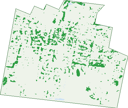
Green: 10 m cells where trees dominate, satellite 2021. Blue: water. The line is the suburb boundary.
| Canopy share, 1 m canopy height map, 2020 | 3.7% |
|---|---|
| Land with trees, 10 m satellite map, 2021 | 7.2% |
Demographics
Unemployment 4% · Labour-force participation 67.7%
Population by age in Alfredton
| 0-4 | 764 |
|---|---|
| 5-14 | 1,950 |
| 15-19 | 936 |
| 20-24 | 756 |
| 25-34 | 1,398 |
| 35-44 | 1,657 |
| 45-54 | 1,517 |
| 55-64 | 1,182 |
| 65-74 | 994 |
| 75-84 | 533 |
| 85+ | 144 |
Dwelling types in Alfredton
| House | 3,728 |
|---|---|
| Townhouse | 162 |
| Apartment | 228 |
| Other | 0 |
Households by weekly income in Alfredton
| <$650 | 509 |
|---|---|
| $650-1,499 | 1,050 |
| $1,500-2,999 | 1,334 |
| $3,000+ | 985 |
Top ancestries in Alfredton
| English | 4,703 |
|---|---|
| Australian | 4,454 |
| Irish | 1,660 |
| Scottish | 1,455 |
| Other | 977 |
| Indian | 538 |
Housing tenure in Alfredton
| Owned | 1,286 |
|---|---|
| Mortgage | 1,550 |
| Rented | 1,235 |
| Other | 19 |
Cars per household in Alfredton
| 0 | 131 |
|---|---|
| 1 | 1,347 |
| 2 | 1,832 |
| 3 | 526 |
| 4+ | 265 |
Commute to work in Alfredton
| Car | 4,078 |
|---|---|
| Train | 17 |
| Bus | 20 |
| Tram/ferry | 0 |
| Walked | 50 |
| Bicycle | 32 |
| Home | 867 |
Top countries of birth in Alfredton
| India | 469 |
|---|---|
| England | 208 |
| China | 149 |
| New Zealand | 108 |
| Philippines | 68 |
| Sri Lanka | 65 |
Languages used at home in Alfredton
| Mandarin | 221 |
|---|---|
| Malayalam | 197 |
| Punjabi | 126 |
| Hindi | 109 |
| Sinhalese | 64 |
| Greek | 50 |
Birds & Wildlife Nearby
174,789 bird observations recorded near Alfredton — most often seen:
- Black Swan (10,462)
- Eurasian Coot (10,036)
- Pacific Black Duck (10,016)
- Magpie-lark (9,922)
- Australasian Purple Swamphen (9,035)
- Dusky Moorhen (8,997)
- Little Pied Cormorant (7,692)
- Little Raven (7,567)
- Australian Wood Duck (7,235)
- Red Wattlebird (7,147)
- Silver Gull (6,809)
- Australian White Ibis (6,596)
- Musk Duck (5,836)
Show all 30 birds recorded near Alfredton
- Superb Fairy-wren (5,715)
- Common Starling (5,663)
- Eurasian Blackbird (5,323)
- Rainbow Lorikeet (5,230)
- Grey Teal (5,120)
- Southern Victoria Australian Magpie (4,984)
- Crested Pigeon (4,263)
- Southern Masked Lapwing (3,956)
- Australian Reed Warbler (3,873)
- Hoary-headed Grebe (3,734)
- Welcome Swallow (3,354)
- Little Black Cormorant (3,006)
- Australian Magpie (2,845)
- Brown Thornbill (2,806)
- Masked Lapwing (2,689)
- Long-billed Corella (2,464)
- Australasian Grebe (2,414)
Sightings reported by observers, not a survey, so the counts show what people record rather than what lives here. Source: Atlas of Living Australia.
Nearby Suburbs
The closest suburbs to Alfredton:
- Lake Gardens (2 km)
- Lucas (2.2 km)
- Winter Valley (2.5 km)
- Newington (3.2 km)
- Delacombe (3.4 km)
- Lake Wendouree (3.6 km)
- Wendouree (4 km)
- Redan (4.1 km)
Embed this suburb
Add this free Alfredton stat card to your own site — just copy the code:
Preview:
Cite this page
Quoting these figures? Copy the credit line:
Keep an eye on Alfredton
One email when this data meaningfully changes — new census figures, prices, rankings. No spam, unsubscribe anytime.
Streets
- Abattoir Street (1)
- Abbey Court (8)
- Aberdeen Street (7)
- Adrianus Street (36)
- Albany Close (5)
- Alfredton Drive (130)
- Allura Drive (9)
- Almurta Street (25)
- Amana Drive (19)
- Anton Drive (23)
- Arch Drive (36)
- Argyle Crescent (21)
- Armagh Street (29)
- Arrandale Avenue (53)
- Arthur Street (17)
- Arwon Crescent (6)
- Ashbourne Court (10)
- Ashley Court (15)
- Aspect Parade (82)
- Avoca Crescent (33)
- Balanada Close (31)
- Ballarat-carngham Road (43)
- Balyarta Street (21)
- Bannister Street (16)
- Basil Way (16)
- Beaufort Avenue (26)
- Beldi Street (27)
- Belfast Road (10)
- Bellington Drive (14)
- Belltower Avenue (54)
- Boulevarde Drive (37)
- Brewster Street (20)
- Brompton Place (7)
- Calgiari Drive (13)
- Caligari Way (13)
- Calma Street (11)
- Canopy Avenue (54)
- Capital Street (23)
- Carbine Drive (21)
- Cardigan Avenue (21)
- Cardwell Street (15)
- Carlow Drive (11)
- Caroline Street (25)
- Carrum Street (16)
- Cavan Grove (22)
- Cedar Avenue (25)
- Chase Boulevard (56)
- Chelsea Place (9)
- Cheviot Court (21)
- Christine Avenue (38)
- Cleveland Court (5)
- Clovedale Avenue (50)
- Colonial Court (8)
- Coonatta Street (23)
- Copeworth Court (10)
- Cordover Court (13)
- Cork Street (10)
- Corriedale Court (13)
- Corryong Court (16)
- Cotswold Drive (16)
- Cottesloe Place (12)
- Course View Drive (10)
- Crawford Road (7)
- Creekstone Drive (52)
- Cuthberts Road (239)
- Cuzens Road (52)
- Darlington Street (15)
- Dartmoor Court (19)
- Distinction Drive (13)
- Donegal Drive (13)
- Doramy Court (5)
- Dorset Drive (66)
- Dromana Street (18)
- Drysdale Court (11)
- Dublin Street (22)
- Dyson Drive (87)
- Eaton Close (6)
- Echo Place (24)
- Elaine Avenue (81)
- Elliotdale Court (9)
- Endeavour Way (22)
- Evergreen Drive (34)
- Exmoor Court (17)
- Fermanagh Street (16)
- Fitzgerald Avenue (9)
- Fonteyn Court (3)
- Franklin Court (12)
- Galway Drive (37)
- Gillies Street S (87)
- Gillingham Place (2)
- Goldwood Drive (26)
- Golf Street (6)
- Greenedge Drive (10)
- Gregory Street W (2)
- Grosvenor Court (4)
- Harmony Way (18)
- Harold Court (21)
- Hathaway Close (15)
- Horsham Crescent (18)
- Hume Crescent (35)
- Iluka Court (4)
- Indi Street (26)
- Insignia Boulevard (29)
- Jack Court (19)
- Jacob Court (14)
- Jarrah Drive (18)
- Joseph Court (4)
- Kalamata Avenue (39)
- Kallioota Street (44)
- Karol Street (53)
- Kilkenny Drive (43)
- Lancaster Street (16)
- Lansell Court (4)
- Lauderdale Avenue (30)
- Lawrence Street (35)
- Lawrie Drive (66)
- Learmonth Street (132)
- Leicester Court (13)
- Leitrim Street (27)
- Lemon Street (21)
- Leopold Street (25)
- Lesley Court (13)
- Limerick Street (22)
- Linton Court (7)
- Longford Road (47)
- Longley Street (146)
- Lugano Avenue (80)
- Luxford Street (7)
- Lyndon Court (8)
- Magnetic Drive (20)
- Mary Drive (61)
- Mayo Street (20)
- Meredith Court (9)
- Merino Drive (64)
- Mia Street (41)
- Michaels Drive (25)
- Micich Court (9)
- Mimosa Avenue (54)
- Monaghan Terrace (28)
- Montadale Court (16)
- Moseley Street (11)
- Mullingar Drive (39)
- Munro Street (45)
- Napier Avenue (10)
- Naroo Street (17)
- Ningana Street (49)
- Nyon Road (9)
- Oberon Street (23)
- Obrien Drive (27)
- Offaly Street (24)
- Omeo Drive (5)
- Opal Avenue (10)
- Opal Street (10)
- Oxley Bend (7)
- Paley Court (18)
- Paramount Parade (13)
- Parkmead Way (9)
- Parkview Drive (53)
- Parkwood Street (13)
- Peppertree Court (11)
- Perendale Street (19)
- Peridot Way (16)
- Polwarth Court (7)
- Portsea Street (15)
- Prince Of Wales Boulevard (21)
- Prince Street (28)
- Production Drive (39)
- Providence Place (12)
- Regal Drive (22)
- Regent Court (5)
- Ring Road (12)
- Robertson Drive (70)
- Rockingham Place (13)
- Roscommon Avenue (29)
- Rosney Court (6)
- Rundell Place (10)
- Rutherford Place (1)
- Ryeland Court (5)
- Sage Close (22)
- Samuel Court (8)
- Sapphire Drive (11)
- Scarborough Crescent (41)
- Seaford Street (27)
- Shannon Close (4)
- Sienna Street (14)
- Signature Drive (40)
- Skyline Drive (5)
- Sligo Street (22)
- Sorrento Drive (42)
- Southdown Court (14)
- Sparkling Close (22)
- Sturt Street (210)
- Suffolk Court (13)
- Sunline Avenue (18)
- Swamp Gum Place (9)
- Sydney Way (71)
- Tangerine Street (11)
- The Terrace (23)
- Tipperary Street (29)
- Topaz Street (19)
- Townsend Court (10)
- Towong Street (26)
- Tralee Road (2)
- Twin Court (3)
- Vale Street (129)
- Verdale Drive (85)
- Vetrano Avenue (32)
- Victory Avenue (58)
- Wallace Place (7)
- Walters Way (25)
- Warwick Road (3)
- Waterway Drive (17)
- Wensleydale Drive (25)
- Wexford Street (89)
- Whitely Crescent (10)
- Willoby Drive (98)
- Windsor Avenue (24)
- Winter Street (3)
- Zircon Drive (12)
- Zircon Street (12)
- Zofia Place (10)