Whyalla Norrie SA 5608
4,100 addresses · 140 streets
Grey Electorate › Whyalla LGA › Whyalla Norrie · 233 km from Adelaide
📦 Thinking of moving here? Read the Whyalla Norrie moving guide

Living Here
Whyalla Norrie is a suburb of South Australia, home to about 6,288 people, with a median age of 39. The typical household earns around $1,071 a week, with median rent near $180 a week. Most homes are townhouses. About 55% of households own their home and 44% rent. Most workers drive to work. Common community backgrounds include English, Australian, Scottish. On the ABS socio-economic scale it sits in decile 1 of 10 nationally — a more disadvantaged area.
Over time — Census 2001 → 2021
Dashed line: district figures for the Whyalla statistical area (SA2), the smallest area the ABS published before 2011. Solid line: Whyalla Norrie itself.
Getting Around & Local Services
7 cafés & restaurants
5 supermarkets
1 pharmacy
5 doctors & medical clinics
2 dentists
1 hospital
1 childcare centre
1 library
5 service stations
3 gyms & sports centres
1 golf club
2 bakeries
1 butcher
3 hardware stores
3 hairdressers
1 mechanic
Getting around. Airport: Whyalla Airport, 4.1 km south-west.
Socio-economic Standing
Deciles from 1 (lowest) to 10 (highest), against all Australian suburbs. The overall figure weighs advantage and disadvantage together; economic resources counts income and housing, and education & jobs counts qualifications and occupation. They often differ. Source: ABS SEIFA 2021.
Tree cover
🌳 Tree canopy: 1.7% share of land under canopy · satellite map, 2020
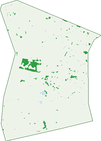
Green: 10 m cells where trees dominate, satellite 2021. Blue: water. The line is the suburb boundary.
| Canopy share, 1 m canopy height map, 2020 | 1.7% |
|---|---|
| Land with trees, 10 m satellite map, 2021 | 2.0% |
Demographics
Unemployment 9.2% · Labour-force participation 54.2%
Population by age in Whyalla Norrie
| 0-4 | 355 |
|---|---|
| 5-14 | 827 |
| 15-19 | 356 |
| 20-24 | 404 |
| 25-34 | 825 |
| 35-44 | 703 |
| 45-54 | 867 |
| 55-64 | 855 |
| 65-74 | 569 |
| 75-84 | 419 |
| 85+ | 113 |
Dwelling types in Whyalla Norrie
| House | 1,167 |
|---|---|
| Townhouse | 1,488 |
| Apartment | 58 |
| Other | 3 |
Households by weekly income in Whyalla Norrie
| <$650 | 714 |
|---|---|
| $650-1,499 | 916 |
| $1,500-2,999 | 639 |
| $3,000+ | 238 |
Top ancestries in Whyalla Norrie
| English | 2,640 |
|---|---|
| Australian | 2,478 |
| Scottish | 650 |
| German | 455 |
| Ancestry NS | 438 |
| Irish | 403 |
Housing tenure in Whyalla Norrie
| Owned | 641 |
|---|---|
| Mortgage | 830 |
| Rented | 1,188 |
| Other | 23 |
Cars per household in Whyalla Norrie
| 0 | 370 |
|---|---|
| 1 | 1,083 |
| 2 | 790 |
| 3 | 295 |
| 4+ | 120 |
Commute to work in Whyalla Norrie
| Car | 1,852 |
|---|---|
| Train | 0 |
| Bus | 57 |
| Tram/ferry | 0 |
| Walked | 57 |
| Bicycle | 25 |
| Home | 42 |
Top countries of birth in Whyalla Norrie
| England | 371 |
|---|---|
| Philippines | 174 |
| Scotland | 99 |
| India | 71 |
| New Zealand | 46 |
| Germany | 39 |
Languages used at home in Whyalla Norrie
| Tagalog | 79 |
|---|---|
| Filipino | 62 |
| Tamil | 37 |
| Punjabi | 28 |
| Greek | 26 |
| Afrikaans | 23 |
Birds & Wildlife Nearby
8,192 bird observations recorded near Whyalla Norrie — most often seen:
- Silver Gull (456)
- Grey Teal (438)
- Hoary-headed Grebe (396)
- Red Wattlebird (382)
- Welcome Swallow (353)
- Chestnut Teal (350)
- Singing Honeyeater (321)
- Spiny-cheeked Honeyeater (321)
- Crested Pigeon (319)
- Eurasian Coot (319)
- Black-tailed Native-hen (292)
- Common Starling (291)
- Magpie-lark (267)
Show all 30 birds recorded near Whyalla Norrie
- Pacific Black Duck (267)
- Masked Lapwing (263)
- Galah (259)
- New Holland Honeyeater (249)
- White-faced Heron (239)
- Nankeen Kestrel (216)
- Black Swan (215)
- Little Black Cormorant (214)
- House Sparrow (208)
- Australian Magpie (204)
- Little Pied Cormorant (203)
- Eastern Welcome Swallow (201)
- Giinbaywarraymal (201)
- Red-kneed Dotterel (201)
- Australian Pelican (189)
- Rock Dove (183)
- Mainland White-winged Fairy-wren (175)
Sightings reported by observers, not a survey, so the counts show what people record rather than what lives here. Source: Atlas of Living Australia.
Nearby Suburbs
The closest suburbs to Whyalla Norrie:
- Whyalla Stuart (1.6 km)
- Whyalla Playford (1.9 km)
- Whyalla Jenkins (2.6 km)
- Whyalla (3.5 km)
- Whyalla Barson (3.6 km)
- Mullaquana (3.9 km)
- False Bay (16.6 km)
- Port Bonython (22.3 km)
Embed this suburb
Add this free Whyalla Norrie stat card to your own site — just copy the code:
Preview:
Cite this page
Quoting these figures? Copy the credit line:
Keep an eye on Whyalla Norrie
One email when this data meaningfully changes — new census figures, prices, rankings. No spam, unsubscribe anytime.
Streets
- Aikman Crescent (46)
- Anesbury Street (79)
- Angela Marino Court (6)
- Atkinson Street (32)
- Baldwinson Street (43)
- Barngarla Avenue (1)
- Barrie Robran Gate (14)
- Bellchamber Court (3)
- Benier Street (25)
- Broadbent Terrace (10)
- Brodie Street (32)
- Brown Street (16)
- Buddy Newchurch Place (16)
- Burns Street (21)
- Butchart Court (10)
- Button Street (11)
- Carl Veart Avenue (11)
- Cartledge Avenue (15)
- Charles Avenue (89)
- Choat Street (15)
- Clark Crescent (29)
- Clee Street (22)
- Clutterbuck Street (26)
- Constable Place (9)
- Cook Street (14)
- Cowled Street (20)
- Crowhurst Street (1)
- Davis Street (6)
- Davison Street (30)
- Dow Street (16)
- Dowd Street (19)
- Duffy Street (4)
- Ebert Street (55)
- Edgar Street (31)
- Ekblom Street (25)
- Emery Street (6)
- Essington Lewis Avenue (1)
- Eyre Avenue (76)
- Fisk Street (40)
- Flavel Street (17)
- Flew Street (16)
- Gallagher Street (20)
- Garrard Street (6)
- Garwood Street (18)
- Gass Street (20)
- George Avenue (73)
- Gilfillan Street (22)
- Gordon Street (64)
- Graeme Jose Place (6)
- Graham Cornes Court (7)
- Gregor Street (16)
- Grundel Street (21)
- Hanley Street (34)
- Harvey Street (44)
- Hawdon Street (1)
- Haynes Street (42)
- Hazel Court (4)
- Heath Street (28)
- Henderson Street (25)
- Henshelwood Street (7)
- Heurich Terrace (44)
- Heward Street (37)
- Hincks Avenue (133)
- Hobbs Street (27)
- Ian Street (2)
- Jackson Avenue (63)
- Jacobs Street (25)
- Jacquier Crescent (42)
- James Street (30)
- Jenkins Avenue (217)
- Jones Street (19)
- Julie Francou Place (11)
- Karingal Close (39)
- Kayser Street (17)
- Kinnane Street (40)
- Kloeden Street (28)
- Knuckey Street (31)
- Kramer Street (21)
- Lewthwaite Street (62)
- Lincoln Highway (1)
- Lindsay Street (37)
- Litchfield Street (19)
- Long Street (9)
- Loveday Street (48)
- Mcbryde Terrace (72)
- Mcdouall Stuart Avenue (72)
- Mclennan Avenue (24)
- Mcmahon Street (6)
- Mebberson Street (34)
- Mildred Street (35)
- Miller Street (37)
- Mills Street (104)
- Moran Street (17)
- Morris Crescent (6)
- Mudge Street (35)
- Murn Crescent (21)
- Neil Kerley Court (10)
- Nelligan Street (65)
- Nicolson Avenue (162)
- Norrie Avenue (82)
- Oborn Street (12)
- Oldridge Street (16)
- Opie Street (6)
- Paltridge Street (16)
- Parker Court (12)
- Pattinson Close (19)
- Phillis Street (8)
- Racecourse Road (29)
- Reid Street (14)
- Remilton Street (18)
- Richards Street (22)
- Ring Street (49)
- Rosemary Street (16)
- Rozee Street (32)
- Russell Street (54)
- Ryan Avenue (16)
- Sampson Street (36)
- Schulz Avenue (25)
- Scoble Street (36)
- Searle Street (32)
- Simmons Street (11)
- Sims Street (18)
- Skurray Street (28)
- Sly Street (3)
- Smith Street (19)
- Smoker Street (21)
- Story Street (11)
- Sugg Street (32)
- Sunrise Lane (2)
- Townsend Crescent (10)
- Travers Street (26)
- Trevan Street (43)
- Tyler Crescent (9)
- Vern Schuppan Drive (42)
- Viscount Slim Avenue (75)
- Wade Street (14)
- Walsh Street (27)
- Watts Street (3)
- Whittard Street (6)
- Williams Street (32)