Nairne SA 5252
2,647 addresses · 109 streets
Mayo Electorate › Mount Barker LGA › Nairne · 30 km from Adelaide
📦 Thinking of moving here? Read the Nairne moving guide

Living Here
Nairne is a suburb of South Australia, home to about 5,327 people, with a median age of 36. The typical household earns around $1,776 a week, with median rent near $350 a week. Most homes are houses. About 78% of households own their home and 21% rent. Most workers drive to work. Common community backgrounds include English, Australian, German. On the ABS socio-economic scale it sits in decile 6 of 10 nationally — a mid-range area.
Over time — Census 2001 → 2021
Dashed line: district figures for the Nairne statistical area (SA2), the smallest area the ABS published before 2011. Solid line: Nairne itself.
Getting Around & Local Services
4 cafés & restaurants
1 supermarket
1 pharmacy
1 childcare centre
1 post office
1 service station
3 gyms & sports centres
2 golf clubs
1 bakery
1 butcher
4 hardware stores
1 mechanic
1 place to stay
Getting around. Airport: Adelaide Airport, 35.6 km west.
Socio-economic Standing
Deciles from 1 (lowest) to 10 (highest), against all Australian suburbs. The overall figure weighs advantage and disadvantage together; economic resources counts income and housing, and education & jobs counts qualifications and occupation. They often differ. Source: ABS SEIFA 2021.
Tree cover
🌳 Tree canopy: 8.1% share of land under canopy · satellite map, 2020
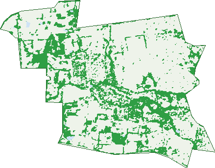
Green: 10 m cells where trees dominate, satellite 2021. Blue: water. The line is the suburb boundary.
| Canopy share, 1 m canopy height map, 2020 | 8.1% |
|---|---|
| Land with trees, 10 m satellite map, 2021 | 27.2% |
Demographics
Unemployment 3.9% · Labour-force participation 71.1%
Population by age in Nairne
| 0-4 | 403 |
|---|---|
| 5-14 | 764 |
| 15-19 | 310 |
| 20-24 | 304 |
| 25-34 | 784 |
| 35-44 | 695 |
| 45-54 | 744 |
| 55-64 | 622 |
| 65-74 | 495 |
| 75-84 | 173 |
| 85+ | 33 |
Dwelling types in Nairne
| House | 1,906 |
|---|---|
| Townhouse | 29 |
| Apartment | 0 |
| Other | 0 |
Households by weekly income in Nairne
| <$650 | 217 |
|---|---|
| $650-1,499 | 530 |
| $1,500-2,999 | 726 |
| $3,000+ | 314 |
Top ancestries in Nairne
| English | 2,444 |
|---|---|
| Australian | 2,377 |
| German | 581 |
| Scottish | 504 |
| Irish | 480 |
| Other | 325 |
Housing tenure in Nairne
| Owned | 478 |
|---|---|
| Mortgage | 1,034 |
| Rented | 402 |
| Other | 20 |
Cars per household in Nairne
| 0 | 35 |
|---|---|
| 1 | 560 |
| 2 | 865 |
| 3 | 300 |
| 4+ | 166 |
Commute to work in Nairne
| Car | 1,964 |
|---|---|
| Train | 0 |
| Bus | 60 |
| Tram/ferry | 0 |
| Walked | 26 |
| Bicycle | 6 |
| Home | 315 |
Top countries of birth in Nairne
| England | 288 |
|---|---|
| New Zealand | 45 |
| South Africa | 33 |
| Germany | 31 |
| Netherlands | 26 |
| Philippines | 17 |
Languages used at home in Nairne
| German | 36 |
|---|---|
| Mandarin | 16 |
| Japanese | 15 |
| Afrikaans | 13 |
| Polish | 11 |
| French | 10 |
Birds & Wildlife Nearby
56,986 bird observations recorded near Nairne — most often seen:
- Grey Teal (2,687)
- Pacific Black Duck (2,637)
- Superb Fairy-wren (2,542)
- Dusky Moorhen (2,492)
- Australasian Purple Swamphen (2,474)
- Chestnut Teal (2,371)
- Australasian Grebe (2,357)
- Eurasian Blackbird (2,357)
- Eurasian Coot (2,348)
- White-plumed Honeyeater (2,174)
- Hoary-headed Grebe (2,112)
- Hardhead (2,100)
- New Holland Honeyeater (2,061)
Show all 30 birds recorded near Nairne
- Red Wattlebird (2,021)
- Australasian Shoveler (1,875)
- Australian Wood Duck (1,812)
- Magpie-lark (1,658)
- Australian Spotted Crake (1,590)
- Little Raven (1,574)
- White-faced Heron (1,573)
- Common Bronzewing (1,568)
- Rainbow Lorikeet (1,557)
- Galah (1,543)
- Australian Reed Warbler (1,542)
- Little Grassbird (1,523)
- Welcome Swallow (1,416)
- Australian White Ibis (1,327)
- Crimson Rosella (1,245)
- Willie Wagtail (1,229)
- Australian Magpie (1,221)
Sightings reported by observers, not a survey, so the counts show what people record rather than what lives here. Source: Atlas of Living Australia.
Nearby Suburbs
The closest suburbs to Nairne:
- Blakiston (2.3 km)
- Hay Valley (2.9 km)
- Mount Barker Junction (3.4 km)
- Littlehampton (3.9 km)
- Mount Barker Summit (4.1 km)
- Dawesley (4.1 km)
- Brukunga (4.9 km)
- Totness (6 km)
Embed this suburb
Add this free Nairne stat card to your own site — just copy the code:
Preview:
Cite this page
Quoting these figures? Copy the credit line:
Keep an eye on Nairne
One email when this data meaningfully changes — new census figures, prices, rankings. No spam, unsubscribe anytime.
Streets
- Adam Court (6)
- Allargue Street (45)
- Allon Place (2)
- Alysha Court (6)
- Amos Road (1)
- Austin Court (9)
- Bald Hills Road (3)
- Bank Street (27)
- Bartley Street (5)
- Bassett Street (32)
- Britannia Road (92)
- Bulbeck Road (12)
- Burns Street (32)
- Bushel Court (5)
- Carmen Court (20)
- Chambers Road (2)
- Chapman Crescent (9)
- Chestnut Drive (30)
- Church Street (9)
- Clezy Court (5)
- Clover Way (23)
- Clydesdale Place (36)
- Cockburn Street (12)
- Commercial Street (16)
- Cower Court (10)
- Craig Drive (25)
- Daniel Court (18)
- De Gacher Street (14)
- De-gacher Street (16)
- Easter Street (10)
- Edinborough Court (4)
- Edinborough Street (49)
- Edis Place (1)
- Elder Street (11)
- Elizabeth Street (35)
- Elm Court (24)
- Emma Road (21)
- Farquharson Street (5)
- Federation Way (37)
- Gabb Court (34)
- Gladstone Street (44)
- Haeusler Drive (49)
- Hanny Crescent (15)
- Hare Road (2)
- Hillier Road (19)
- Hillman Drive (71)
- Hogan Road (5)
- Ironstone Range Road (6)
- Jackson Road (3)
- Jeffrey Street (70)
- Jenner Street (7)
- Jervois Street (35)
- Joanne Street (28)
- Junction Street (3)
- Lawton Court (18)
- Leith Street (1)
- Lesley Road (2)
- Little Dublin East Road (7)
- Lower Nixon Street (29)
- Lungenmuss Court (7)
- Mace Road (5)
- Mais Street (39)
- Margaret Court (27)
- Market Place (73)
- Matthew Road (22)
- Matthew Smillie Drive (102)
- Mckenny Street (9)
- Mcnicol Lane (6)
- Megan Circuit (74)
- Mooney Circuit (21)
- Moyse Court (2)
- Murphy Court (11)
- Nixon Street (7)
- North Railway Terrace (9)
- North Road (177)
- Old Princes Highway (13)
- Packard Street (19)
- Parr Street (37)
- Petwood Road (3)
- Plowman Close (13)
- Preiss Close (15)
- Princes Highway (180)
- Pulleine Road (28)
- Pyrites Road (4)
- Rachel Circuit (81)
- Railway Terrace (8)
- Rider Road (1)
- Rouse Court (20)
- Saleyard Road (21)
- Sandercock Road (1)
- Sargent Street (3)
- Shakes Road (70)
- Shetland Court (34)
- Stirling Road (14)
- Stockham Street (7)
- Sturdeck Street (8)
- Summit Road (33)
- Susan Road (22)
- Sydney Road (14)
- Taylor Way (10)
- Thomas Street (4)
- Thresher Close (13)
- Timmins Road (8)
- Torrens Street (10)
- Walker Court (9)
- Webber Drive (52)
- West Terrace (10)
- William Street (15)
- Woodside Road (109)