Kilburn SA 5084
3,230 addresses · 60 streets
Adelaide Electorate › Port Adelaide Enfield LGA › Kilburn · 8 km from Adelaide
📦 Thinking of moving here? Read the Kilburn moving guide

Living Here
Kilburn is a suburb of South Australia, home to about 5,633 people, with a median age of 34. The typical household earns around $1,179 a week, with median rent near $270 a week. Most homes are houses. About 43% of households own their home and 56% rent. Most workers drive to work. Common community backgrounds include English, Australian, Ancestry NS. On the ABS socio-economic scale it sits in decile 1 of 10 nationally — a more disadvantaged area. The median house sells for about $1,093,556.
Over time — Census 2001 → 2021
Dashed line: district figures for the Enfield - Blair Athol statistical area (SA2), the smallest area the ABS published before 2011. Solid line: Kilburn itself.
Getting Around & Local Services
3 pharmacies
2 doctors & medical clinics
4 physiotherapists
2 optometrists
4 childcare & kindergartens
1 beauty salon
Getting around. Train station: Kilburn, 800 m west · Bus interchange: Klemzig Interchange, 5.5 km south-east · Airport: Adelaide Airport, 10.2 km south-west.
Socio-economic Standing
Deciles from 1 (lowest) to 10 (highest), against all Australian suburbs. The overall figure weighs advantage and disadvantage together; economic resources counts income and housing, and education & jobs counts qualifications and occupation. They often differ. Source: ABS SEIFA 2021.
Median Sale Prices
Median of recorded sales in the period, not a valuation. Source: Metropolitan Median House Sales, Valuer-General South Australia.
Tree cover
🌳 Tree canopy: 6.6% share of land under canopy · satellite map, 2020
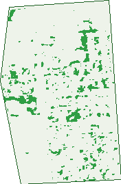
Green: 10 m cells where trees dominate, satellite 2021. Blue: water. The line is the suburb boundary.
| Canopy share, 1 m canopy height map, 2020 | 6.6% |
|---|---|
| Land with trees, 10 m satellite map, 2021 | 4.0% |
Demographics
Unemployment 9.9% · Labour-force participation 53.5%
Population by age in Kilburn
| 0-4 | 348 |
|---|---|
| 5-14 | 606 |
| 15-19 | 281 |
| 20-24 | 479 |
| 25-34 | 1,165 |
| 35-44 | 814 |
| 45-54 | 673 |
| 55-64 | 548 |
| 65-74 | 393 |
| 75-84 | 238 |
| 85+ | 81 |
Dwelling types in Kilburn
| House | 922 |
|---|---|
| Townhouse | 856 |
| Apartment | 222 |
| Other | 6 |
Households by weekly income in Kilburn
| <$650 | 503 |
|---|---|
| $650-1,499 | 639 |
| $1,500-2,999 | 525 |
| $3,000+ | 215 |
Top ancestries in Kilburn
| Other | 2,095 |
|---|---|
| English | 918 |
| Australian | 910 |
| Ancestry NS | 396 |
| Vietnamese | 370 |
| Indian | 349 |
Housing tenure in Kilburn
| Owned | 362 |
|---|---|
| Mortgage | 482 |
| Rented | 1,109 |
| Other | 24 |
Cars per household in Kilburn
| 0 | 325 |
|---|---|
| 1 | 801 |
| 2 | 554 |
| 3 | 186 |
| 4+ | 112 |
Commute to work in Kilburn
| Car | 1,558 |
|---|---|
| Train | 0 |
| Bus | 193 |
| Tram/ferry | 0 |
| Walked | 46 |
| Bicycle | 23 |
| Home | 127 |
Top countries of birth in Kilburn
| Afghanistan | 575 |
|---|---|
| India | 505 |
| Vietnam | 287 |
| Pakistan | 165 |
| Philippines | 100 |
| China | 88 |
Languages used at home in Kilburn
| Vietnamese | 373 |
|---|---|
| Punjabi | 288 |
| Arabic | 137 |
| Persian | 114 |
| Mandarin | 105 |
| Bengali | 105 |
Birds & Wildlife Nearby
50,407 bird observations recorded near Kilburn — most often seen:
- Australian White Ibis (2,519)
- Grey Teal (2,332)
- Eurasian Coot (2,195)
- Pacific Black Duck (2,185)
- Australian Pelican (2,067)
- Chestnut Teal (2,002)
- Little Pied Cormorant (1,998)
- Dusky Moorhen (1,997)
- Black Swan (1,944)
- Spotted Turtle-dove (1,939)
- Magpie-lark (1,803)
- Rock Dove (1,798)
- Little Black Cormorant (1,768)
Show all 30 birds recorded near Kilburn
- Common Starling (1,744)
- Australasian Purple Swamphen (1,720)
- Welcome Swallow (1,581)
- White-faced Heron (1,561)
- House Sparrow (1,515)
- Little Raven (1,490)
- Southern Magpie-lark (1,377)
- Crested Pigeon (1,364)
- Hoary-headed Grebe (1,362)
- Eurasian Blackbird (1,319)
- Willie Wagtail (1,310)
- Silver Gull (1,300)
- Rainbow Lorikeet (1,291)
- Noisy Miner (1,277)
- Eastern Crested Pigeon (1,236)
- Great Egret (1,209)
- New Holland Honeyeater (1,204)
Sightings reported by observers, not a survey, so the counts show what people record rather than what lives here. Source: Atlas of Living Australia.
Nearby Suburbs
The closest suburbs to Kilburn:
- Blair Athol (0.9 km)
- Regency Park (1.5 km)
- Enfield (1.7 km)
- Dudley Park (2.1 km)
- Gepps Cross (2.3 km)
- Prospect (2.4 km)
- Sefton Park (2.4 km)
- Ferryden Park (2.4 km)
Embed this suburb
Add this free Kilburn stat card to your own site — just copy the code:
Preview:
Cite this page
Quoting these figures? Copy the credit line:
Keep an eye on Kilburn
One email when this data meaningfully changes — new census figures, prices, rankings. No spam, unsubscribe anytime.
Streets
- Albert Street (17)
- Bank Street (16)
- Blackburn Street (2)
- Braeville Court (4)
- Brooklyn Terrace (37)
- Brunswick Street (82)
- Bundarra Avenue (34)
- Carroll Avenue (36)
- Chicago Street (4)
- Churchill Road (453)
- Coolah Street (17)
- Cromwell Road (60)
- Dee Avenue (31)
- Denver Terrace (20)
- Eaton Avenue (21)
- Foote Avenue (32)
- Galway Street (92)
- Garland Avenue (71)
- George Street (30)
- Gladstone Avenue (129)
- Goodman Avenue (108)
- Grand Junction Road (14)
- Hastings Road (5)
- Hawkesbury Avenue (50)
- Hillsdale Street (2)
- Hopetoun Avenue (103)
- Horley Terrace (14)
- Inwood Avenue (18)
- Jersey Avenue (120)
- Kintore Avenue (136)
- Kitchener Street (105)
- Lancaster Street (12)
- Le Hunte Street (109)
- Leader Avenue (62)
- Leicester Avenue (43)
- Mackie Avenue (14)
- Mapleton Court (5)
- Marmion Avenue (22)
- Maud Street (20)
- Mill Court (5)
- Miranda Avenue (42)
- Miranda Street (42)
- Montgomery Road (33)
- Moorang Street (31)
- Nelson Street (105)
- Northcote Street (170)
- Palmer Avenue (26)
- Prospect Road (219)
- Railway Terrace (22)
- Severn Avenue (34)
- Solent Avenue (16)
- Stevens Avenue (15)
- Sunnybrae Avenue (16)
- Talinga Avenue (63)
- Tobruk Avenue (18)
- Tyne Avenue (77)
- Wattle Street (2)
- Way Street (108)
- William Street (31)
- Yamba Street (5)