Hackham SA 5163
2,412 addresses · 91 streets
Kingston Electorate › Onkaparinga LGA › Hackham · 25 km from Adelaide
📦 Thinking of moving here? Read the Hackham moving guide

Living Here
Hackham is a suburb of South Australia, home to about 4,491 people, with a median age of 40. The typical household earns around $1,158 a week, with median rent near $297 a week. Most homes are houses. About 75% of households own their home and 24% rent. Most workers drive to work. Common community backgrounds include English, Australian, Scottish. On the ABS socio-economic scale it sits in decile 1 of 10 nationally — a more disadvantaged area. The median house sells for about $770,500.
Over time — Census 2001 → 2021
Dashed line: district figures for the Hackham - Onkaparinga Hills statistical area (SA2), the smallest area the ABS published before 2011. Solid line: Hackham itself.
Getting Around & Local Services
2 pharmacies
3 doctors & medical clinics
4 optometrists
2 childcare & kindergartens
2 libraries
3 gyms & sports centres
1 playground
1 dog park
1 bakery
1 butcher
1 hairdresser
3 mechanics
Getting around. Train station: Noarlunga Centre, 3.6 km west · Bus interchange: Colonnades Centre Interchange, 3.3 km west · Airport: Adelaide Airport, 22.7 km north.
Socio-economic Standing
Deciles from 1 (lowest) to 10 (highest), against all Australian suburbs. The overall figure weighs advantage and disadvantage together; economic resources counts income and housing, and education & jobs counts qualifications and occupation. They often differ. Source: ABS SEIFA 2021.
Median Sale Prices
Median of recorded sales in the period, not a valuation. Source: Metropolitan Median House Sales, Valuer-General South Australia.
Tree cover
🌳 Tree canopy: 11.7% share of land under canopy · satellite map, 2020
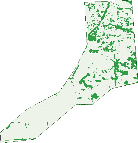
Green: 10 m cells where trees dominate, satellite 2021. Blue: water. The line is the suburb boundary.
| Canopy share, 1 m canopy height map, 2020 | 11.7% |
|---|---|
| Land with trees, 10 m satellite map, 2021 | 12.2% |
Demographics
Unemployment 7.6% · Labour-force participation 54.4%
Population by age in Hackham
| 0-4 | 269 |
|---|---|
| 5-14 | 514 |
| 15-19 | 232 |
| 20-24 | 266 |
| 25-34 | 620 |
| 35-44 | 560 |
| 45-54 | 497 |
| 55-64 | 477 |
| 65-74 | 566 |
| 75-84 | 343 |
| 85+ | 138 |
Dwelling types in Hackham
| House | 1,596 |
|---|---|
| Townhouse | 226 |
| Apartment | 3 |
| Other | 0 |
Households by weekly income in Hackham
| <$650 | 399 |
|---|---|
| $650-1,499 | 681 |
| $1,500-2,999 | 540 |
| $3,000+ | 87 |
Top ancestries in Hackham
| English | 2,189 |
|---|---|
| Australian | 1,730 |
| Scottish | 470 |
| German | 363 |
| Irish | 352 |
| Ancestry NS | 282 |
Housing tenure in Hackham
| Owned | 495 |
|---|---|
| Mortgage | 848 |
| Rented | 421 |
| Other | 25 |
Cars per household in Hackham
| 0 | 124 |
|---|---|
| 1 | 725 |
| 2 | 629 |
| 3 | 203 |
| 4+ | 110 |
Commute to work in Hackham
| Car | 1,385 |
|---|---|
| Train | 14 |
| Bus | 36 |
| Tram/ferry | 0 |
| Walked | 13 |
| Bicycle | 8 |
| Home | 122 |
Top countries of birth in Hackham
| England | 364 |
|---|---|
| Philippines | 62 |
| Scotland | 44 |
| Germany | 42 |
| New Zealand | 31 |
| Netherlands | 23 |
Languages used at home in Hackham
| Tagalog | 19 |
|---|---|
| Italian | 16 |
| German | 15 |
| Filipino | 15 |
| Arabic | 12 |
| Greek | 10 |
Birds & Wildlife Nearby
50,624 bird observations recorded near Hackham — most often seen:
- Little Raven (2,954)
- Rainbow Lorikeet (2,652)
- Common Starling (2,592)
- Southern Magpie-lark (2,364)
- House Sparrow (2,336)
- Eastern New Holland Honeyeater (2,214)
- Rock Dove (2,181)
- Eurasian Blackbird (2,164)
- Eyre Peninsula Australian Magpie (2,124)
- Eastern Crested Pigeon (2,098)
- Western Red Wattlebird (2,074)
- Eastern Asian Spotted Dove (2,058)
- Little Pied Cormorant (1,853)
Show all 30 birds recorded near Hackham
- Pacific Black Duck (1,733)
- Southern Willie Wagtail (1,629)
- White-faced Heron (1,503)
- Australian White Ibis (1,445)
- Giinbaywarraymal (1,427)
- Eastern Galah (1,413)
- Eastern Welcome Swallow (1,352)
- Australian Pelican (1,236)
- Australian Magpie (1,155)
- Grey Teal (1,134)
- Superb Fairy-wren (1,089)
- Red Wattlebird (1,045)
- New Holland Honeyeater (1,012)
- Australasian Purple Swamphen (970)
- South-eastern Musk Lorikeet (965)
- Dusky Moorhen (929)
- Eurasian Coot (923)
Sightings reported by observers, not a survey, so the counts show what people record rather than what lives here. Source: Atlas of Living Australia.
Nearby Suburbs
The closest suburbs to Hackham:
- Onkaparinga Heights (1.1 km)
- Hackham West (1.4 km)
- Huntfield Heights (1.8 km)
- Onkaparinga Hills (1.8 km)
- Morphett Vale (2.8 km)
- Noarlunga Downs (2.9 km)
- Noarlunga Centre (3.2 km)
- Christie Downs (3.6 km)
Embed this suburb
Add this free Hackham stat card to your own site — just copy the code:
Preview:
Cite this page
Quoting these figures? Copy the credit line:
Keep an eye on Hackham
One email when this data meaningfully changes — new census figures, prices, rankings. No spam, unsubscribe anytime.
Streets
- Alexander Crescent (20)
- Arnold Drive (61)
- Bahr Court (2)
- Berkley Court (6)
- Botanic Grove (28)
- Bryant Way (12)
- Burke Street (25)
- Bushby Street (10)
- Cameron Court (4)
- Capeview Crescent (47)
- Carbenet Drive (51)
- Chapman Road (102)
- Chynoweth Avenue (56)
- Colins Way (10)
- Collins Parade (94)
- Cottage Lane (176)
- Crestview Lane (16)
- Daniel Street (7)
- Desmond Road (32)
- Doctors Road (22)
- Edna Court (9)
- Eyre Court (3)
- Flinders Crescent (30)
- Gates Road (56)
- George Avenue (20)
- Graham Avenue (37)
- Green Avenue (11)
- Greengate Grove (24)
- Grenache Road (26)
- Hannah Close (1)
- Harold Lea Way (45)
- Hepenstal Road (27)
- Heylen Court (17)
- Higgins Street (29)
- Highview Court (10)
- Hurley Grove (27)
- John Street (2)
- Kings Court (9)
- Laima Court (5)
- Lance Avenue (10)
- Lea Street (12)
- Lynn Place (27)
- Main South Road (169)
- Mcguire Court (29)
- Melinda Road (24)
- Michael Avenue (18)
- Milton Street (6)
- Mina Parade (3)
- Mountain Ash Court (12)
- Mountain Ash Drive (4)
- Narelle Court (2)
- Nigel Lane (33)
- Noble Circuit (1)
- Norman Crescent (16)
- O'halloran Lane (15)
- Orion Court (22)
- Oxley Court (7)
- Palace Way (10)
- Palomino Place (10)
- Panorama Avenue (26)
- Paramount Avenue (16)
- Parkview Rise (57)
- Patapinda Road (5)
- Paterson Drive (45)
- Patricia Grove (8)
- Penneys Hill Road (177)
- Pethick Way (7)
- Piggott Range Road (4)
- Regents Close (5)
- Richard Avenue (18)
- Rio Court (10)
- River Heights Rise (4)
- Samuel Street (19)
- Sandy Lane (30)
- Scenic Way (93)
- Scholars Way (11)
- Shiraz Avenue (16)
- Stanley Street (4)
- States Road (79)
- Stewart Avenue (26)
- Sturt Lane (52)
- Surrey Place (5)
- Susan Road (23)
- Sylvia Way (1)
- Tasman Court (6)
- Torrens Avenue (5)
- Vincent Court (6)
- Vinest Way (5)
- Viney Court (5)
- Vintage Avenue (41)
- Wills Street (4)