Bordertown SA 5268
2,092 addresses · 131 streets
Barker Electorate › Tatiara LGA › Bordertown · 249 km from Adelaide
📦 Thinking of moving here? Read the Bordertown moving guide

Living Here
Bordertown is a suburb of South Australia, home to about 3,095 people, with a median age of 40. The typical household earns around $1,439 a week, with median rent near $220 a week. Most homes are houses. About 71% of households own their home and 26% rent. Most workers drive to work. Common community backgrounds include Australian, English, German. On the ABS socio-economic scale it sits in decile 2 of 10 nationally — a more disadvantaged area.
Over time — Census 2001 → 2021
Dashed line: district figures for the Tatiara statistical area (SA2), the smallest area the ABS published before 2011. Solid line: Bordertown itself.
Getting Around & Local Services
3 cafés & restaurants
1 supermarket
1 medical clinic
1 hospital
1 childcare centre
1 library
1 post office
4 service stations
1 gym
1 golf club
1 dog park
2 bakeries
1 butcher
1 hardware store
1 hairdresser
1 beauty salon
Socio-economic Standing
Deciles from 1 (lowest) to 10 (highest), against all Australian suburbs. The overall figure weighs advantage and disadvantage together; economic resources counts income and housing, and education & jobs counts qualifications and occupation. They often differ. Source: ABS SEIFA 2021.
Tree cover
🌳 Tree canopy: 2.6% share of land under canopy · satellite map, 2020
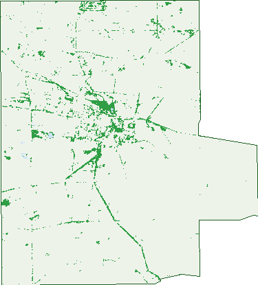
Green: 10 m cells where trees dominate, satellite 2021. Blue: water. The line is the suburb boundary.
| Canopy share, 1 m canopy height map, 2020 | 2.6% |
|---|---|
| Land with trees, 10 m satellite map, 2021 | 4.2% |
Demographics
Unemployment 2.2% · Labour-force participation 64.2%
Population by age in Bordertown
| 0-4 | 173 |
|---|---|
| 5-14 | 353 |
| 15-19 | 145 |
| 20-24 | 199 |
| 25-34 | 436 |
| 35-44 | 393 |
| 45-54 | 359 |
| 55-64 | 354 |
| 65-74 | 317 |
| 75-84 | 249 |
| 85+ | 109 |
Dwelling types in Bordertown
| House | 1,079 |
|---|---|
| Townhouse | 72 |
| Apartment | 0 |
| Other | 14 |
Households by weekly income in Bordertown
| <$650 | 174 |
|---|---|
| $650-1,499 | 388 |
| $1,500-2,999 | 353 |
| $3,000+ | 152 |
Top ancestries in Bordertown
| Australian | 1,210 |
|---|---|
| English | 1,092 |
| Other | 409 |
| German | 280 |
| Scottish | 227 |
| Irish | 198 |
Housing tenure in Bordertown
| Owned | 394 |
|---|---|
| Mortgage | 418 |
| Rented | 300 |
| Other | 32 |
Cars per household in Bordertown
| 0 | 43 |
|---|---|
| 1 | 396 |
| 2 | 457 |
| 3 | 145 |
| 4+ | 103 |
Commute to work in Bordertown
| Car | 1,301 |
|---|---|
| Train | 0 |
| Bus | 4 |
| Tram/ferry | 0 |
| Walked | 65 |
| Bicycle | 17 |
| Home | 74 |
Top countries of birth in Bordertown
| Philippines | 100 |
|---|---|
| Malaysia | 93 |
| Afghanistan | 68 |
| New Zealand | 44 |
| China | 39 |
| Pakistan | 34 |
Languages used at home in Bordertown
| Filipino | 62 |
|---|---|
| Mandarin | 46 |
| Urdu | 32 |
| Tamil | 28 |
| Tagalog | 21 |
| Vietnamese | 10 |
Birds & Wildlife Nearby
5,401 bird observations recorded near Bordertown — most often seen:
- Pacific Black Duck (365)
- Eastern Rosella (247)
- Magpie-lark (247)
- Australian Wood Duck (245)
- Australian Magpie (234)
- Noisy Miner (234)
- Eurasian Coot (231)
- Chestnut Teal (227)
- Australasian Grebe (208)
- Grey Teal (203)
- Rainbow Lorikeet (190)
- Willie Wagtail (184)
- Galah (175)
Show all 30 birds recorded near Bordertown
- Common Starling (174)
- White-plumed Honeyeater (174)
- Red Wattlebird (157)
- Hoary-headed Grebe (155)
- Red-rumped Parrot (154)
- Bush Stone-curlew (150)
- Black Swan (143)
- Crested Pigeon (143)
- Sulphur-crested Cockatoo (140)
- Welcome Swallow (139)
- Long-billed Corella (137)
- House Sparrow (134)
- Australian Shelduck (133)
- Southern Victoria Australian Magpie (128)
- Dusky Moorhen (125)
- Hardhead (113)
- New Holland Honeyeater (112)
Sightings reported by observers, not a survey, so the counts show what people record rather than what lives here. Source: Atlas of Living Australia.
Nearby Suburbs
The closest suburbs to Bordertown:
- Mundulla (9.3 km)
- Cannawigara (10.6 km)
- Pine Hill (11.7 km)
- Bordertown South (12.9 km)
- Wolseley (13.7 km)
- Pooginagoric (14.7 km)
- Senior (17.4 km)
- Lowan Vale (18.2 km)
Embed this suburb
Add this free Bordertown stat card to your own site — just copy the code:
Preview:
Cite this page
Quoting these figures? Copy the credit line:
Keep an eye on Bordertown
One email when this data meaningfully changes — new census figures, prices, rankings. No spam, unsubscribe anytime.
Streets
- Adamson Terrace (21)
- Aerodrome Road (3)
- Albert Parade (21)
- Baker Street (16)
- Benjamin Street (6)
- Bennett Street (1)
- Bertha Street (31)
- Beryl Court (8)
- Billy Lane (7)
- Binnie Street (30)
- Brompton Street (6)
- Brown Terrace (6)
- Buik Street (14)
- Bull Oak Flat Road (2)
- Campbell Street (28)
- Cannawigara Road (110)
- Chark Road (1)
- Clayton Farm Track (2)
- Cleggett Road (6)
- Cotton Street (33)
- Creecoona Terrace (18)
- Crocker Street (24)
- Curnow Road (4)
- Davis Street (6)
- De Courcey Street (25)
- Densley Avenue (37)
- Dinning Terrace (36)
- Dukes Highway (37)
- Dunn Street (24)
- East Terrace (12)
- Eastern Service Road (2)
- Edward Street (17)
- Eighth Street (14)
- Elizabeth Avenue (8)
- Elizabeth Street (5)
- England Road (9)
- English Street (11)
- Eveline Street (19)
- Farquhar Street (12)
- Fifth Street (10)
- Finlayson Road (1)
- First Street (7)
- Florence Street (6)
- Fourth Street (17)
- Frances Road (16)
- Fullarton Street (5)
- Glyde Street (27)
- Golf Course Road (21)
- Grace Street (7)
- Green Street (25)
- Gum Avenue (7)
- Handyside Terrace (16)
- Hay Street (15)
- Haynes Street (24)
- High Street (7)
- Hill Street (1)
- Hubl Road (2)
- Inglis Road (4)
- Jenkin Road (1)
- Jervois Street (13)
- Kathleen Street (7)
- Kerslake Street (24)
- Killmier Terrace (13)
- Marian Street (12)
- Marston Terrace (11)
- Mclean Avenue (11)
- Mclellan Road (8)
- Mcleod Street (34)
- Meatworks Road (6)
- Melvyn Street (17)
- Merrett Road (5)
- Milne Street (34)
- Mona Street (7)
- Murray Street (14)
- Nalang Road (4)
- Naracoorte Road (64)
- North Terrace (13)
- O'connell Road (5)
- O'connells Road (1)
- O'halloran Street (3)
- Oatmill Road (6)
- Oliver Street (12)
- Osborne Court (7)
- Park Terrace (76)
- Patterson Street (17)
- Peake Street (18)
- Penny Terrace (3)
- Phelps Street (6)
- Philip Avenue (11)
- Pigeon Flat Road (49)
- Power House Road (1)
- Proslie Street (15)
- Racecourse Road (21)
- Railway Parade S (1)
- Ramsay Terrace (52)
- Ramsay Terrace N (2)
- Richards Lane (3)
- Riches Street (2)
- Rouse Street (2)
- Salom Street (40)
- Scott Lane (5)
- Scott Street (25)
- Second Street (13)
- Senior Road (25)
- Seventh Street (15)
- Short Street (1)
- Six Mile Well Road (1)
- Sixth Street (12)
- Smith Avenue (19)
- Smith Street (15)
- South Avenue (68)
- South Terrace (10)
- Sullivan Road (2)
- Sullivans Road (1)
- Tatiara Road (8)
- Tatiara Terrace (29)
- Third Street (11)
- Thomas Court (5)
- Tolmer Terrace (9)
- Vauxhall Street (1)
- Venn Avenue (50)
- Victoria Parade (80)
- Virgo Street (12)
- Weir Drive (13)
- Wellington Street (21)
- West Terrace (19)
- Western Drive (21)
- Western Service Road (1)
- Wiese Road (2)
- Winter Road (3)
- Woolshed Street (54)