Worongary QLD 4213
2,671 addresses · 122 streets
Wright Electorate › Gold Coast LGA › Worongary · 70 km from Brisbane
📦 Thinking of moving here? Read the Worongary moving guide

Living Here
Worongary is a suburb of Queensland, home to about 6,021 people, with a median age of 40. The typical household earns around $2,160 a week, with median rent near $450 a week. Most homes are houses. About 86% of households own their home and 13% rent. Most workers drive to work. Common community backgrounds include English, Australian, Irish. On the ABS socio-economic scale it sits in decile 7 of 10 nationally — a mid-range area.
Over time — Census 2001 → 2021
Dashed line: district figures for the Worongary - Tallai statistical area (SA2), the smallest area the ABS published before 2011. Solid line: Worongary itself.
Getting Around & Local Services
2 Catholic churches
1 pharmacy
1 medical clinic
1 physiotherapist
2 libraries
4 gyms & sports centres
1 dog park
1 butcher
3 hardware stores
2 electricians
Getting around. Train station: Nerang, 4.8 km north · Bus interchange: Greyhound Bus Terminal Surfers Paradise, 9.2 km north-east · Airport: Southport Flying Club, 13 km north.
Socio-economic Standing
Deciles from 1 (lowest) to 10 (highest), against all Australian suburbs. The overall figure weighs advantage and disadvantage together; economic resources counts income and housing, and education & jobs counts qualifications and occupation. They often differ. Source: ABS SEIFA 2021.
Tree cover
🌳 Tree canopy: 44.2% share of land under canopy · satellite map, 2020
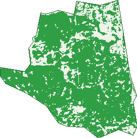
Green: 10 m cells where trees dominate, satellite 2021. Blue: water. The line is the suburb boundary.
| Canopy share, 1 m canopy height map, 2020 | 44.2% |
|---|---|
| Land with trees, 10 m satellite map, 2021 | 79.7% |
Demographics
Unemployment 4.5% · Labour-force participation 67.4%
Population by age in Worongary
| 0-4 | 352 |
|---|---|
| 5-14 | 814 |
| 15-19 | 458 |
| 20-24 | 343 |
| 25-34 | 611 |
| 35-44 | 846 |
| 45-54 | 923 |
| 55-64 | 815 |
| 65-74 | 543 |
| 75-84 | 263 |
| 85+ | 59 |
Dwelling types in Worongary
| House | 1,815 |
|---|---|
| Townhouse | 0 |
| Apartment | 29 |
| Other | 0 |
Households by weekly income in Worongary
| <$650 | 174 |
|---|---|
| $650-1,499 | 400 |
| $1,500-2,999 | 615 |
| $3,000+ | 506 |
Top ancestries in Worongary
| English | 2,698 |
|---|---|
| Australian | 2,185 |
| Irish | 656 |
| Scottish | 638 |
| Other | 462 |
| Ancestry NS | 339 |
Housing tenure in Worongary
| Owned | 562 |
|---|---|
| Mortgage | 1,017 |
| Rented | 244 |
| Other | 13 |
Cars per household in Worongary
| 0 | 23 |
|---|---|
| 1 | 292 |
| 2 | 780 |
| 3 | 389 |
| 4+ | 340 |
Commute to work in Worongary
| Car | 2,181 |
|---|---|
| Train | 11 |
| Bus | 10 |
| Tram/ferry | 0 |
| Walked | 22 |
| Bicycle | 11 |
| Home | 415 |
Top countries of birth in Worongary
| New Zealand | 373 |
|---|---|
| England | 306 |
| South Africa | 87 |
| China | 33 |
| United States | 32 |
| Germany | 31 |
Languages used at home in Worongary
| Mandarin | 44 |
|---|---|
| Japanese | 31 |
| Afrikaans | 23 |
| Hindi | 19 |
| Spanish | 18 |
| French | 15 |
Birds & Wildlife Nearby
22,294 bird observations recorded near Worongary — most often seen:
- Rainbow Lorikeet (1,229)
- Torresian Crow (1,213)
- Australian White Ibis (1,171)
- Magpie-lark (1,120)
- Noisy Miner (1,036)
- Pacific Black Duck (969)
- Australian Magpie (962)
- Welcome Swallow (878)
- Common Myna (870)
- Willie Wagtail (845)
- Dusky Moorhen (839)
- Pied Currawong (836)
- Australasian Purple Swamphen (769)
Show all 30 birds recorded near Worongary
- Little Corella (736)
- Masked Lapwing (704)
- Superb Fairy-wren (646)
- Crested Pigeon (643)
- Brown Honeyeater (632)
- Australian Wood Duck (611)
- Spotted Turtle-dove (601)
- Sulphur-crested Cockatoo (600)
- Magpie Goose (587)
- Blue-faced Honeyeater (543)
- Little Black Cormorant (518)
- Australasian Figbird (507)
- Pied Butcherbird (495)
- Laughing Kookaburra (468)
- Little Pied Cormorant (426)
- Eurasian Coot (425)
- Noisy Friarbird (415)
Sightings reported by observers, not a survey, so the counts show what people record rather than what lives here. Source: Atlas of Living Australia.
Nearby Suburbs
The closest suburbs to Worongary:
- Highland Park (2.6 km)
- Merrimac (2.7 km)
- Carrara (3.1 km)
- Gilston (3.3 km)
- Tallai (3.6 km)
- Nerang (4.6 km)
- Benowa (5.5 km)
- Clear Island Waters (5.6 km)
Embed this suburb
Add this free Worongary stat card to your own site — just copy the code:
Preview:
Cite this page
Quoting these figures? Copy the credit line:
Keep an eye on Worongary
One email when this data meaningfully changes — new census figures, prices, rankings. No spam, unsubscribe anytime.
Streets
- Albert Evans Drive (34)
- Alice Bowden Court (18)
- Alkira Way (22)
- Andamooka Avenue (36)
- Arthur Payne Court (14)
- Aurora Crescent (12)
- Barrine Drive (56)
- Borman Court (20)
- Bronzewing Street (7)
- Carl Lentz Court (13)
- Carpenter Court (23)
- Caspian Close (12)
- Challenger Street (7)
- Charland Court (4)
- Charles Kurz Drive (57)
- Chillagoe Place (9)
- Cozens Way (5)
- Creekside Court (10)
- Crocker Street (6)
- Curragh Court (7)
- Currawong Circuit (47)
- Daly Way (9)
- Delta Cove Drive (27)
- Dormello Drive (21)
- Dorrigo Drive (23)
- Ebeling Court (11)
- Eungella Court (5)
- Explorers Way (74)
- Fallon Court (19)
- Fergus Court (6)
- Firetail Street (16)
- Francho Street (5)
- Frank Burg Court (5)
- Giles Grove (6)
- Glenn Court (10)
- Greyjack Court (6)
- Grissom Court (15)
- Grosvenor Court (53)
- Hackworth Court (10)
- Hamersley Way (21)
- Handel Avenue (51)
- Hannah Court (8)
- Harry Mills Drive (71)
- Hinkler Drive (52)
- Hugh Guinea Court (23)
- Ida Court (6)
- Incline Drive (14)
- Jakes Way (24)
- Jeremy Court (8)
- Jindivick Street (6)
- John Nielsen Court (11)
- Kabra Court (2)
- Kalbari Court (10)
- Kambalda Court (19)
- Kaputar Court (5)
- Keryn Close (7)
- Kestrel Street (15)
- Kingfisher Court (12)
- Kurilpa Street (9)
- Kurnell Court (4)
- Leisure Lane (19)
- Lexington Drive (53)
- Lovell Court (8)
- Lyrebird Road (10)
- Majtlis Place (4)
- Margaret Bruce Court (9)
- Marina Court (13)
- Mataranka Drive (20)
- Mcdivitt Court (21)
- Mckavanagh Place (5)
- Meadowland Court (11)
- Moura Road (5)
- Mudgeeraba Road (70)
- Nabarlek Drive (27)
- Nancy Yaun Court (14)
- Nash Road (6)
- Newhaven Crescent (22)
- Norseman Crescent (22)
- Oriental Street (16)
- Oriole Street (25)
- Osprey Rise (59)
- Oyster Street (13)
- Parkway Circuit (39)
- Petrel Crescent (50)
- Pilbara Place (13)
- Pinjarra Place (4)
- Pipit Street (14)
- Quambone Street (99)
- Random Way (32)
- Ride Court (9)
- Rouse Street (30)
- Rufous Street (13)
- Rushworth Street (20)
- San Fernando Drive (177)
- Sanderling Road (25)
- Sandpiper Terrace (61)
- Saraji Street (14)
- Scarlet Street (15)
- Sevenoaks Court (14)
- Sheldon Court (15)
- Shuttle Place (5)
- Smiggin Street (3)
- Songlark Street (15)
- Stanhope Court (14)
- The Pinnacle (44)
- The Spur (20)
- Thomas Duncan Court (24)
- Thredbo Drive (56)
- Tom Latimer Court (11)
- Ulm Place (5)
- Vince Hinde Drive (25)
- Virgil Court (22)
- Voyager Court (16)
- Walcoy Place (11)
- Walker Drive (29)
- Whistler Way (6)
- Widden Court (18)
- William Hollindale Court (15)
- Wirraway Place (4)
- Worongary Road (98)
- Yampi Place (5)
- Yarandin Court (11)