Windsor QLD 4030
5,929 addresses · 115 streets
Brisbane Electorate › Brisbane LGA › Windsor · 4 km from Brisbane
📦 Thinking of moving here? Read the Windsor moving guide

Living Here
Windsor is a suburb of Queensland, home to about 7,811 people, with a median age of 32. The typical household earns around $2,213 a week, with median rent near $400 a week. Most homes are houses. About 44% of households own their home and 56% rent. Most workers drive to work. Common community backgrounds include English, Australian, Irish. On the ABS socio-economic scale it sits in decile 10 of 10 nationally — a relatively advantaged area.
Over time — Census 2001 → 2021
Dashed line: district figures for the Windsor statistical area (SA2), the smallest area the ABS published before 2011. Solid line: Windsor itself.
Getting Around & Local Services
1 beach
25 hospitals
- Rosemount Hospital
- Royal Brisbane and Women’s Hospital
- St Andrews War Memorial Private Hospital
- Alderley Child Health
- Brisbane Private Hospital
- Evolve Therapeutic Services
- Saint Vincent's Private Hospital Brisbane
- St Vincent's Private Hospital Northside
- Nundah Community Health Centre
- The Prince Charles Hospital
23 childcare & kindergartens
1 butcher
Getting around. Train station: Windsor, 250 m south-west · Bus interchange: RBW Hospital, 1.4 km south · Ferry wharf: Teneriffe Ferry Terminal, 2.7 km south-east · Airport: Brisbane Airport, 10.8 km north-east.
Socio-economic Standing
Deciles from 1 (lowest) to 10 (highest), against all Australian suburbs. The overall figure weighs advantage and disadvantage together; economic resources counts income and housing, and education & jobs counts qualifications and occupation. They often differ. Source: ABS SEIFA 2021.
Tree cover
🌳 Tree canopy: 16% share of land under canopy · satellite map, 2020
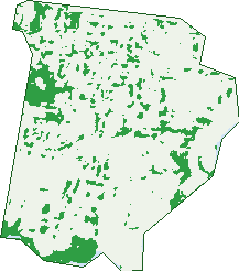
Green: 10 m cells where trees dominate, satellite 2021. Blue: water. The line is the suburb boundary.
| Canopy share, 1 m canopy height map, 2020 | 16.0% |
|---|---|
| Land with trees, 10 m satellite map, 2021 | 11.1% |
Demographics
Unemployment 3.7% · Labour-force participation 76.9%
Population by age in Windsor
| 0-4 | 377 |
|---|---|
| 5-14 | 703 |
| 15-19 | 374 |
| 20-24 | 898 |
| 25-34 | 2,035 |
| 35-44 | 1,184 |
| 45-54 | 987 |
| 55-64 | 617 |
| 65-74 | 377 |
| 75-84 | 175 |
| 85+ | 81 |
Dwelling types in Windsor
| House | 1,607 |
|---|---|
| Townhouse | 162 |
| Apartment | 1,479 |
| Other | 0 |
Households by weekly income in Windsor
| <$650 | 364 |
|---|---|
| $650-1,499 | 637 |
| $1,500-2,999 | 1,049 |
| $3,000+ | 1,026 |
Top ancestries in Windsor
| English | 2,884 |
|---|---|
| Australian | 2,526 |
| Irish | 1,175 |
| Other | 1,055 |
| Scottish | 1,003 |
| Italian | 438 |
Housing tenure in Windsor
| Owned | 534 |
|---|---|
| Mortgage | 873 |
| Rented | 1,783 |
| Other | 21 |
Cars per household in Windsor
| 0 | 320 |
|---|---|
| 1 | 1,396 |
| 2 | 1,115 |
| 3 | 267 |
| 4+ | 114 |
Commute to work in Windsor
| Car | 2,192 |
|---|---|
| Train | 246 |
| Bus | 285 |
| Tram/ferry | 0 |
| Walked | 152 |
| Bicycle | 81 |
| Home | 1,200 |
Top countries of birth in Windsor
| England | 256 |
|---|---|
| New Zealand | 214 |
| India | 130 |
| Nepal | 118 |
| China | 67 |
| Philippines | 60 |
Languages used at home in Windsor
| Spanish | 125 |
|---|---|
| Nepali | 110 |
| Mandarin | 108 |
| Italian | 87 |
| Portuguese | 55 |
| Cantonese | 42 |
Birds & Wildlife Nearby
126,672 bird observations recorded near Windsor — most often seen:
- Noisy Miner (10,367)
- Torresian Crow (9,148)
- Australian White Ibis (8,413)
- Rainbow Lorikeet (8,050)
- Welcome Swallow (6,425)
- Magpie-lark (5,545)
- Australian Magpie (5,398)
- Rock Dove (4,945)
- Dusky Moorhen (4,813)
- Pied Currawong (4,707)
- Grey Butcherbird (4,657)
- Australasian Figbird (4,643)
- Australian Brush-turkey (4,254)
Show all 30 birds recorded near Windsor
- Pied Butcherbird (4,082)
- Laughing Kookaburra (3,749)
- Bush Stone-curlew (3,546)
- Blue-faced Honeyeater (3,436)
- Pacific Black Duck (3,223)
- Scaly-breasted Lorikeet (3,141)
- Willie Wagtail (2,944)
- Masked Lapwing (2,577)
- Crested Pigeon (2,417)
- Spotted Turtle-dove (2,400)
- Common Myna (2,260)
- Sulphur-crested Cockatoo (2,107)
- Australian Wood Duck (1,991)
- Galah (1,908)
- Black-faced Cuckoo-shrike (1,862)
- Silver Gull (1,854)
- Little Pied Cormorant (1,810)
Sightings reported by observers, not a survey, so the counts show what people record rather than what lives here. Source: Atlas of Living Australia.
Nearby Suburbs
The closest suburbs to Windsor:
- Wilston (1.2 km)
- Albion (1.3 km)
- Lutwyche (1.4 km)
- Bowen Hills (1.7 km)
- Herston (1.7 km)
- Grange (1.9 km)
- Wooloowin (1.9 km)
- Gordon Park (2 km)
Embed this suburb
Add this free Windsor stat card to your own site — just copy the code:
Preview:
Cite this page
Quoting these figures? Copy the credit line:
Keep an eye on Windsor
One email when this data meaningfully changes — new census figures, prices, rankings. No spam, unsubscribe anytime.
Streets
- Ada Street (37)
- Addison Street (18)
- Albany Street (8)
- Albion Road (155)
- Algar Street (52)
- Allom Street (8)
- Anderson Street (5)
- Annie Street (42)
- Antill Street (1)
- Arwin Terrace (28)
- Baird Street (34)
- Bank Street (9)
- Batchelor Street (8)
- Bess Street (41)
- Blackmore Street (125)
- Bonython Street (142)
- Bowen Street (125)
- Bowser Street (24)
- Brickfield Street (29)
- Brook Street (73)
- Brown Street (27)
- Bryden Street (139)
- Bush Street (15)
- Byrne Street (7)
- Cameron Street (7)
- Campbell Street (21)
- Cartwright Street (155)
- Constitution Road (110)
- Cox Road (49)
- Crowther Street (30)
- Cullen Street (36)
- Cumberland Street (35)
- Downey Street (22)
- Drury Street (20)
- Earle Street (55)
- Edgar Street (1)
- Edmund Street (6)
- Eildon Road (88)
- Elam Street (6)
- Epacras Street (14)
- Fairleigh Street (28)
- Federation Street (35)
- Fifth Avenue (78)
- Flaherty Street (1)
- Flower Street (19)
- Fosbery Street (69)
- Gallway Street (234)
- Gennon Street (16)
- Gilbert Road (47)
- Goodacre Street (4)
- Gould Road (4)
- Grafton Street (100)
- Graham Street (18)
- Grantson Street (191)
- Green Terrace (62)
- Haddock Street (7)
- Hadfield Street (17)
- Harris Lane (6)
- Harris Street (49)
- Hawdon Street (2)
- Hooker Street (108)
- Horace Street (12)
- Jessop Street (9)
- Kennedy Street (9)
- Kidman Street (5)
- Lane Street (2)
- Le Geyt Street (297)
- Leda Street (2)
- Legeyt Street (301)
- Lutwyche Road (397)
- Lyons Terrace (43)
- Mackay Street (45)
- Main Avenue (69)
- Martha Street (5)
- Maurice Street (5)
- Maygar Street (130)
- Mcdonald Road (65)
- Mckenzie Street (14)
- Melbourne Street (8)
- Moore Street (3)
- Morris Street (7)
- Newmarket Road (235)
- Nicholas Street (35)
- Noble Street (1)
- Northey Street (39)
- Oakwal Lane (2)
- Oakwal Terrace (50)
- Palmer Street (66)
- Parsons Street (2)
- Peter Street (1)
- Prospect Road (3)
- Reid Street (9)
- Robert Lane (1)
- Roblane Street (67)
- Rosemount Terrace (131)
- Rougham Street (22)
- Rupert Street (12)
- Salt Street (109)
- Seventh Avenue (50)
- Silvester Street (2)
- Sixth Avenue (91)
- Somerset Street (96)
- Stafford Street (24)
- Storkey Street (19)
- Swan Terrace (74)
- Taylor Street (32)
- Tenth Avenue (54)
- Thondley Street (46)
- Thorne Street (41)
- Truro Street (47)
- Turner Street (36)
- Victoria Street (133)
- Walker Street (29)
- Whish Street (36)
- Wight Street (4)