Whitfield QLD 4870
2,379 addresses · 73 streets
Leichhardt Electorate › Cairns LGA › Whitfield · 1394 km from Brisbane
📦 Thinking of moving here? Read the Whitfield moving guide

Living Here
Whitfield is a suburb of Queensland, home to about 4,262 people, with a median age of 45. The typical household earns around $1,681 a week, with median rent near $340 a week. Most homes are houses. About 68% of households own their home and 30% rent. Most workers drive to work. Common community backgrounds include English, Australian, Irish. On the ABS socio-economic scale it sits in decile 7 of 10 nationally — a mid-range area.
Over time — Census 2001 → 2021
Dashed line: district figures for the Whitfield - Edge Hill statistical area (SA2), the smallest area the ABS published before 2011. Solid line: Whitfield itself.
Getting Around & Local Services
4 supermarkets
1 pharmacy
3 doctors & medical clinics
1 optometrist
1 vet
2 childcare & kindergartens
5 gyms & sports centres
1 golf club
2 playgrounds
2 dog parks
2 bakeries
2 butchers
3 hardware stores
2 plumbers
Getting around. Train station: Freshwater, 3.4 km north-west · Bus interchange: Airport Connect Terminal 2, 4.2 km north-east · Ferry wharf: Reef Fleet Terminal, 5.7 km east · Airport: Cairns Airport, 3.8 km north-east.
Socio-economic Standing
Deciles from 1 (lowest) to 10 (highest), against all Australian suburbs. The overall figure weighs advantage and disadvantage together; economic resources counts income and housing, and education & jobs counts qualifications and occupation. They often differ. Source: ABS SEIFA 2021.
Tree cover
🌳 Tree canopy: 65.5% share of land under canopy · satellite map, 2020
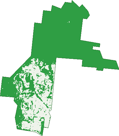
Green: 10 m cells where trees dominate, satellite 2021. Blue: water. The line is the suburb boundary.
| Canopy share, 1 m canopy height map, 2020 | 65.5% |
|---|---|
| Land with trees, 10 m satellite map, 2021 | 75.0% |
Demographics
Unemployment 3.5% · Labour-force participation 64.1%
Population by age in Whitfield
| 0-4 | 154 |
|---|---|
| 5-14 | 555 |
| 15-19 | 243 |
| 20-24 | 141 |
| 25-34 | 496 |
| 35-44 | 516 |
| 45-54 | 694 |
| 55-64 | 552 |
| 65-74 | 444 |
| 75-84 | 284 |
| 85+ | 176 |
Dwelling types in Whitfield
| House | 1,345 |
|---|---|
| Townhouse | 327 |
| Apartment | 23 |
| Other | 0 |
Households by weekly income in Whitfield
| <$650 | 248 |
|---|---|
| $650-1,499 | 454 |
| $1,500-2,999 | 443 |
| $3,000+ | 398 |
Top ancestries in Whitfield
| English | 1,690 |
|---|---|
| Australian | 1,359 |
| Other | 629 |
| Irish | 559 |
| Scottish | 469 |
| German | 251 |
Housing tenure in Whitfield
| Owned | 559 |
|---|---|
| Mortgage | 580 |
| Rented | 511 |
| Other | 33 |
Cars per household in Whitfield
| 0 | 67 |
|---|---|
| 1 | 680 |
| 2 | 645 |
| 3 | 218 |
| 4+ | 70 |
Commute to work in Whitfield
| Car | 1,363 |
|---|---|
| Train | 0 |
| Bus | 13 |
| Tram/ferry | 0 |
| Walked | 22 |
| Bicycle | 48 |
| Home | 334 |
Top countries of birth in Whitfield
| England | 191 |
|---|---|
| New Zealand | 112 |
| Japan | 56 |
| Philippines | 47 |
| India | 44 |
| Scotland | 39 |
Languages used at home in Whitfield
| Japanese | 97 |
|---|---|
| Australian Indigenous | 31 |
| Mandarin | 29 |
| German | 25 |
| Italian | 21 |
| Tagalog | 20 |
Birds & Wildlife Nearby
229,589 bird observations recorded near Whitfield — most often seen:
- Common Myna (14,539)
- Willie Wagtail (12,686)
- Magpie-lark (12,257)
- Masked Lapwing (11,773)
- Rainbow Lorikeet (10,538)
- Torresian Imperial-pigeon (10,493)
- Peaceful Dove (9,913)
- Australasian Figbird (8,560)
- Welcome Swallow (7,952)
- Australian White Ibis (7,891)
- White-breasted Woodswallow (7,260)
- Rock Dove (7,161)
- Rainbow Bee-eater (7,149)
Show all 30 birds recorded near Whitfield
- Metallic Starling (7,053)
- Black Butcherbird (7,047)
- Orange-footed Scrubfowl (7,029)
- Bush Stone-curlew (6,657)
- Sulphur-crested Cockatoo (6,626)
- Australian Brush-turkey (6,485)
- Spangled Drongo (6,323)
- Brown Honeyeater (6,190)
- Helmeted Friarbird (6,091)
- Australian Swiftlet (5,825)
- Great Egret (5,507)
- Pacific Black Duck (5,485)
- House Sparrow (5,416)
- Varied Honeyeater (5,291)
- Yellow Oriole (4,813)
- Mistletoebird (4,809)
- Spotted Turtle-dove (4,770)
Sightings reported by observers, not a survey, so the counts show what people record rather than what lives here. Source: Atlas of Living Australia.
Nearby Suburbs
The closest suburbs to Whitfield:
- Edge Hill (1.3 km)
- Manoora (1.5 km)
- Brinsmead (1.6 km)
- Kanimbla (2 km)
- Manunda (2.6 km)
- Freshwater (3.1 km)
- Stratford (3.2 km)
- Mooroobool (3.3 km)
Embed this suburb
Add this free Whitfield stat card to your own site — just copy the code:
Preview:
Cite this page
Quoting these figures? Copy the credit line:
Keep an eye on Whitfield
One email when this data meaningfully changes — new census figures, prices, rankings. No spam, unsubscribe anytime.
Streets
- Aldinga Close (7)
- Atherton Street (34)
- Balzer Close (11)
- Bel-air Drive (21)
- Bolton Street (34)
- Bott Street (7)
- Bradford Street (24)
- Briggs Close (16)
- Brooks Street (74)
- Byrnes Close (11)
- Carmelo Close (6)
- Crowley Close (7)
- Crowther Street (9)
- Deshon Street (35)
- Di Savia Close (15)
- Draper Place (9)
- Duignan Street (37)
- Flecker Street (33)
- Fogarty Street (24)
- Fry Close (17)
- Fulton Close (15)
- Gloucester Street (39)
- Grace Close (7)
- Greenslopes Street (2)
- Gummow Close (15)
- Heavey Crescent (55)
- Hellmuth Street (14)
- Hillview Crescent (168)
- Hodel Street (37)
- Holden Close (26)
- Hudson Street (22)
- Hutchinson Street (9)
- Ireland Crescent (68)
- Jensen Street (100)
- Keirle Avenue (25)
- Keith Street (53)
- Keller Close (16)
- Kevin Street (38)
- Knott Court (21)
- Knowles Street (10)
- Lockwood Close (5)
- Marino Street (37)
- Mchugh Crescent (31)
- Mckinlay Street (20)
- Mcmanus Street (273)
- Mona Street (20)
- Moule Drive (5)
- Mullins Street (19)
- Murchison Street (32)
- Neeve Close (7)
- Nesbit Street (65)
- Nolan Street (108)
- Norris Street (31)
- Ormsby Close (14)
- Panoramic Place (16)
- Park Street (7)
- Penny Close (12)
- Ponticello Street (47)
- Prescott Street (7)
- Redwood Street (19)
- Reservoir Road (2)
- Rhapis Court (10)
- Rogers Close (18)
- Seary Close (25)
- Sommerville Crescent (31)
- Stirling Street (28)
- Trucano Close (43)
- Trundle Terrace (44)
- Turner Street (53)
- Upper Richardson Street (62)
- Winfield Street (4)
- Woodward Street (62)
- York Street (51)