Westlake QLD 4074
1,663 addresses · 85 streets
Oxley Electorate › Brisbane LGA › Westlake · 14 km from Brisbane
📦 Thinking of moving here? Read the Westlake moving guide

Living Here
Westlake is a suburb of Queensland, home to about 4,547 people, with a median age of 43. The typical household earns around $2,691 a week, with median rent near $550 a week. Most homes are houses. About 88% of households own their home and 11% rent. Most workers drive to work. Common community backgrounds include English, Australian, Irish. On the ABS socio-economic scale it sits in decile 10 of 10 nationally — a relatively advantaged area.
Over time — Census 2001 → 2021
Dashed line: district figures for the Westlake statistical area (SA2), the smallest area the ABS published before 2011. Solid line: Westlake itself.
Getting Around & Local Services
5 supermarkets
3 pharmacies
4 doctors & medical clinics
1 physiotherapist
3 optometrists
3 childcare & kindergartens
2 libraries
1 post office
2 bakeries
2 butchers
3 hardware stores
1 hairdresser
3 beauty salons
1 electrician
2 plumbers
2 places to stay
Getting around. Train station: Darra station, 4.3 km south-east · Bus interchange: Mount Ommaney, 2.5 km east · Ferry wharf: Moggill, 7.5 km south-west · Airport: Brisbane Airport, 28 km north-east.
Socio-economic Standing
Deciles from 1 (lowest) to 10 (highest), against all Australian suburbs. The overall figure weighs advantage and disadvantage together; economic resources counts income and housing, and education & jobs counts qualifications and occupation. They often differ. Source: ABS SEIFA 2021.
Tree cover
🌳 Tree canopy: 15.7% share of land under canopy · satellite map, 2020
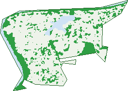
Green: 10 m cells where trees dominate, satellite 2021. Blue: water. The line is the suburb boundary.
| Canopy share, 1 m canopy height map, 2020 | 15.7% |
|---|---|
| Land with trees, 10 m satellite map, 2021 | 21.0% |
Demographics
Unemployment 4.2% · Labour-force participation 65.6%
Population by age in Westlake
| 0-4 | 231 |
|---|---|
| 5-14 | 641 |
| 15-19 | 301 |
| 20-24 | 242 |
| 25-34 | 371 |
| 35-44 | 581 |
| 45-54 | 631 |
| 55-64 | 713 |
| 65-74 | 574 |
| 75-84 | 205 |
| 85+ | 52 |
Dwelling types in Westlake
| House | 1,460 |
|---|---|
| Townhouse | 46 |
| Apartment | 0 |
| Other | 0 |
Households by weekly income in Westlake
| <$650 | 98 |
|---|---|
| $650-1,499 | 256 |
| $1,500-2,999 | 423 |
| $3,000+ | 628 |
Top ancestries in Westlake
| English | 1,606 |
|---|---|
| Australian | 1,205 |
| Other | 609 |
| Irish | 468 |
| Scottish | 456 |
| Chinese | 436 |
Housing tenure in Westlake
| Owned | 654 |
|---|---|
| Mortgage | 666 |
| Rented | 165 |
| Other | 9 |
Cars per household in Westlake
| 0 | 24 |
|---|---|
| 1 | 331 |
| 2 | 760 |
| 3 | 259 |
| 4+ | 130 |
Commute to work in Westlake
| Car | 1,332 |
|---|---|
| Train | 34 |
| Bus | 46 |
| Tram/ferry | 0 |
| Walked | 10 |
| Bicycle | 12 |
| Home | 537 |
Top countries of birth in Westlake
| England | 192 |
|---|---|
| New Zealand | 141 |
| China | 136 |
| Vietnam | 125 |
| South Africa | 108 |
| India | 88 |
Languages used at home in Westlake
| Mandarin | 191 |
|---|---|
| Vietnamese | 191 |
| Cantonese | 124 |
| Tamil | 74 |
| Persian | 71 |
| Hindi | 45 |
Birds & Wildlife Nearby
107,471 bird observations recorded near Westlake — most often seen:
- Noisy Miner (6,545)
- Torresian Crow (6,406)
- Rainbow Lorikeet (6,214)
- Australian Magpie (5,391)
- Sulphur-crested Cockatoo (5,189)
- Grey Butcherbird (4,419)
- Scaly-breasted Lorikeet (4,320)
- Laughing Kookaburra (4,300)
- Pied Currawong (3,993)
- Pied Butcherbird (3,980)
- Lewin's Honeyeater (3,818)
- Masked Lapwing (3,541)
- Welcome Swallow (3,323)
Show all 30 birds recorded near Westlake
- Australasian Figbird (3,201)
- Striated Pardalote (3,199)
- Australian Wood Duck (3,133)
- Eastern Whipbird (3,088)
- Willie Wagtail (2,990)
- Magpie-lark (2,856)
- Pacific Black Duck (2,843)
- Black-faced Cuckoo-shrike (2,691)
- Pale-headed Rosella (2,686)
- Blue-faced Honeyeater (2,606)
- Australian Brush-turkey (2,553)
- Eastern Rainbow Lorikeet (2,461)
- Galah (2,424)
- Noisy Friarbird (2,408)
- Olive-backed Oriole (2,403)
- Brown Honeyeater (2,276)
- Spangled Drongo (2,214)
Sightings reported by observers, not a survey, so the counts show what people record rather than what lives here. Source: Atlas of Living Australia.
Nearby Suburbs
The closest suburbs to Westlake:
- Middle Park (1.2 km)
- Riverhills (1.4 km)
- Pinjarra Hills (1.8 km)
- Mount Ommaney (2.2 km)
- Jamboree Heights (2.3 km)
- Sumner (2.8 km)
- Jindalee (3 km)
- Bellbowrie (3.6 km)
Embed this suburb
Add this free Westlake stat card to your own site — just copy the code:
Preview:
Cite this page
Quoting these figures? Copy the credit line:
Keep an eye on Westlake
One email when this data meaningfully changes — new census figures, prices, rankings. No spam, unsubscribe anytime.
Streets
- Amadeus Place (22)
- Avinia Place (11)
- Ayr Close (4)
- Baikal Place (27)
- Balaton Street (16)
- Ballard Place (15)
- Barbel Close (3)
- Barcoorah Street (45)
- Baronga Street (2)
- Barrine Close (5)
- Bellambi Place (10)
- Bellfield Place (22)
- Bibras Street (3)
- Blanc Close (4)
- Bonney Place (18)
- Buffalo Street (7)
- Bulan Street (5)
- Bundoran Close (7)
- Burnside Crescent (39)
- Callabonna Street (57)
- Carnegie Street (49)
- Clutha Street (21)
- Colac Court (8)
- Congo Street (25)
- Correa Close (10)
- Cowal Close (9)
- Deborah Place (25)
- Doran Close (5)
- Eacham Close (2)
- Earn Close (9)
- Everard Street (18)
- Frangipani Street (5)
- Gidgi Close (10)
- Gillen Close (3)
- Grasmere Street (11)
- Hilliup Street (11)
- Hindmarsh Place (15)
- Horizon Drive (195)
- Kaboora Crescent (34)
- Kadgo Place (6)
- Kasba Close (6)
- La Belle Court (8)
- Lefroy Close (6)
- Loffs Road (2)
- Lomatia Close (11)
- Lucerne Street (6)
- Madura Close (3)
- Malata Close (4)
- Mallery Street (9)
- Maribor Street (25)
- Meadowbank Court (6)
- Menindee Court (7)
- Moyle Close (4)
- Newell Place (21)
- Nisbet Street (15)
- Nyasa Close (5)
- Oron Close (6)
- Ottawa Street (31)
- Penong Street (52)
- Raeside Street (80)
- Riga Close (4)
- Riverview Close (9)
- Roper Close (6)
- Rowallan Close (12)
- Seabrook Circuit (41)
- Shasta Close (8)
- Tabor Street (19)
- Tana Street (7)
- Tandou Street (2)
- Tarrabool Street (47)
- Tebera Street (3)
- Tekapo Street (40)
- Tennent Street (38)
- Timaru Close (11)
- Tolaga Street (27)
- Urmia Close (5)
- Waigen Close (4)
- Wendouree Crescent (55)
- Westlake Drive (185)
- Wivenhoe Court (6)
- Wyara Close (14)
- Yantara Court (6)
- Yarra Close (6)
- Yarrunga Court (7)
- Zambesi Street (1)