West End QLD 4810
3,095 addresses · 60 streets
Herbert Electorate › Townsville LGA › West End · 1112 km from Brisbane
📦 Thinking of moving here? Read the West End moving guide

Living Here
West End is a suburb of Queensland, home to about 3,891 people, with a median age of 40. The typical household earns around $1,402 a week, with median rent near $250 a week. Most homes are houses. About 47% of households own their home and 52% rent. Most workers drive to work. Common community backgrounds include English, Australian, Irish. On the ABS socio-economic scale it sits in decile 4 of 10 nationally — a mid-range area.
Over time — Census 2001 → 2021
Dashed line: district figures for the Garbutt - West End statistical area (SA2), the smallest area the ABS published before 2011. Solid line: West End itself.
Getting Around & Local Services
2 beaches
1 Catholic church
3 doctors & medical clinics
2 dentists
2 physiotherapists
3 optometrists
1 childcare centre
3 bakeries
3 hardware stores
2 electricians
Getting around. Train station: Townsville, 1.7 km east · Ferry wharf: Magnetic Island Ferries - Townsville Terminal, 3.7 km east · Airport: RAAF Base Townsville, 2.5 km west.
Socio-economic Standing
Deciles from 1 (lowest) to 10 (highest), against all Australian suburbs. The overall figure weighs advantage and disadvantage together; economic resources counts income and housing, and education & jobs counts qualifications and occupation. They often differ. Source: ABS SEIFA 2021.
Tree cover
🌳 Tree canopy: 15.5% share of land under canopy · satellite map, 2020
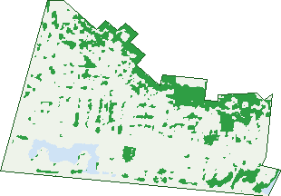
Green: 10 m cells where trees dominate, satellite 2021. Blue: water. The line is the suburb boundary.
| Canopy share, 1 m canopy height map, 2020 | 15.5% |
|---|---|
| Land with trees, 10 m satellite map, 2021 | 17.1% |
Demographics
Unemployment 5.2% · Labour-force participation 64.1%
Population by age in West End
| 0-4 | 204 |
|---|---|
| 5-14 | 359 |
| 15-19 | 179 |
| 20-24 | 287 |
| 25-34 | 621 |
| 35-44 | 543 |
| 45-54 | 594 |
| 55-64 | 533 |
| 65-74 | 354 |
| 75-84 | 182 |
| 85+ | 42 |
Dwelling types in West End
| House | 882 |
|---|---|
| Townhouse | 754 |
| Apartment | 153 |
| Other | 10 |
Households by weekly income in West End
| <$650 | 347 |
|---|---|
| $650-1,499 | 548 |
| $1,500-2,999 | 511 |
| $3,000+ | 262 |
Top ancestries in West End
| English | 1,471 |
|---|---|
| Australian | 1,289 |
| Irish | 503 |
| Scottish | 449 |
| Other | 408 |
| Ancestry NS | 323 |
Housing tenure in West End
| Owned | 341 |
|---|---|
| Mortgage | 493 |
| Rented | 913 |
| Other | 21 |
Cars per household in West End
| 0 | 187 |
|---|---|
| 1 | 825 |
| 2 | 553 |
| 3 | 133 |
| 4+ | 69 |
Commute to work in West End
| Car | 1,498 |
|---|---|
| Train | 0 |
| Bus | 16 |
| Tram/ferry | 0 |
| Walked | 58 |
| Bicycle | 46 |
| Home | 126 |
Top countries of birth in West End
| England | 106 |
|---|---|
| New Zealand | 96 |
| India | 34 |
| Philippines | 33 |
| United States | 26 |
| Germany | 25 |
Languages used at home in West End
| Mandarin | 21 |
|---|---|
| Spanish | 18 |
| Australian Indigenous | 17 |
| German | 17 |
| Italian | 16 |
| Greek | 13 |
Birds & Wildlife Nearby
89,584 bird observations recorded near West End — most often seen:
- Australian White Ibis (5,839)
- Masked Lapwing (4,890)
- Peaceful Dove (4,534)
- Rainbow Bee-eater (4,339)
- Rainbow Lorikeet (3,972)
- Magpie-lark (3,965)
- Brown Honeyeater (3,506)
- White-breasted Woodswallow (3,478)
- Common Myna (3,296)
- Welcome Swallow (3,268)
- Great Bowerbird (3,219)
- White-gaped Honeyeater (3,207)
- Great Egret (2,880)
Show all 30 birds recorded near West End
- Blue-faced Honeyeater (2,811)
- Australasian Figbird (2,767)
- Spangled Drongo (2,507)
- Nutmeg Munia (2,451)
- Australasian Darter (2,395)
- Yellow Honeyeater (2,386)
- Bush Stone-curlew (2,373)
- Pacific Black Duck (2,360)
- Rock Dove (2,322)
- Little Black Cormorant (2,318)
- Magpie Goose (2,263)
- Intermediate Egret (2,121)
- Australian Magpie (2,118)
- Little Pied Cormorant (2,117)
- Silver Gull (2,049)
- Brown-backed Honeyeater (1,928)
- Black Kite (1,905)
Sightings reported by observers, not a survey, so the counts show what people record rather than what lives here. Source: Atlas of Living Australia.
Nearby Suburbs
The closest suburbs to West End:
- Hyde Park (1.5 km)
- Castle Hill (1.9 km)
- Belgian Gardens (1.9 km)
- Pimlico (2 km)
- Currajong (2 km)
- Hermit Park (2.3 km)
- Garbutt (2.4 km)
- North Ward (2.4 km)
Embed this suburb
Add this free West End stat card to your own site — just copy the code:
Preview:
Cite this page
Quoting these figures? Copy the credit line:
Keep an eye on West End
One email when this data meaningfully changes — new census figures, prices, rankings. No spam, unsubscribe anytime.
Streets
- Barron Street (12)
- Baxter Street (28)
- Bundock Street (28)
- Carrington Street (10)
- Castling Street (18)
- Charters Towers Road (4)
- Church Street (52)
- Claude Street (7)
- Cowley Street (60)
- Crauford Street (96)
- Echlin Street (86)
- Edwards Street (46)
- Ernest Street (5)
- Estate Street (41)
- Francis Street (139)
- Garrick Street (68)
- Green Street (14)
- Greenslade Street (41)
- Greer Lane (1)
- Harold Street (158)
- Henry Street (213)
- Hugh Street (88)
- Humphrey Street (61)
- Ingham Road (205)
- James Street (9)
- Jane Street (2)
- John Street (12)
- Kings Road (10)
- Lamington Road (43)
- Leigh Street (79)
- Livingstone Street (77)
- Margaret Street (35)
- Martinez Avenue (244)
- Mary Street (93)
- Maryvale Street (25)
- Mcclelland Street (11)
- Montgomery Street (23)
- Morris Street (19)
- Musgrave Street (16)
- Nix Street (52)
- Norman Street (7)
- North Street (63)
- Parkes Street (6)
- Penny Lane (7)
- Percy Street (68)
- Plant Street (55)
- Ralston Street (119)
- Scully Street (18)
- Shaw Street (35)
- Sidney Street (23)
- Stagpole Street (179)
- Sturt Street (28)
- Townsville Street (38)
- Tuffley Street (85)
- Valentine Court (1)
- Vaughan Street (22)
- Vaughn Street (25)
- William Street (55)
- Wilson Street (15)
- Woodman Court (15)