Urangan QLD 4655
8,837 addresses · 198 streets
Hinkler Electorate › Fraser Coast LGA › Urangan · 242 km from Brisbane
📦 Thinking of moving here? Read the Urangan moving guide

Living Here
A coastal suburb of Hervey Bay and gateway to Fraser Island, Urangan is a popular retirement and holiday area with an older profile (median age 55). Households average 2.2 people. Median household income is $984 a week, with rent around $335.
Urangan is a suburb of Queensland, home to about 10,988 people, with a median age of 55. The typical household earns around $984 a week, with median rent near $335 a week. Most homes are houses. About 68% of households own their home and 31% rent. Most workers drive to work. Common community backgrounds include English, Australian, Scottish. On the ABS socio-economic scale it sits in decile 2 of 10 nationally — a more disadvantaged area.
Over time — Census 2001 → 2021
Dashed line: district figures for the Urangan - Wondunna statistical area (SA2), the smallest area the ABS published before 2011. Solid line: Urangan itself.
Getting Around & Local Services
3 supermarkets
2 beaches
1 Catholic church
1 vet
1 library
1 post office
5 service stations
4 gyms & sports centres
1 golf club
1 bakery
1 hardware store
Getting around. Bus interchange: Hervey Bay Airport, 2.9 km south · Airport: Hervey Bay Airport, 3 km south.
Socio-economic Standing
Deciles from 1 (lowest) to 10 (highest), against all Australian suburbs. The overall figure weighs advantage and disadvantage together; economic resources counts income and housing, and education & jobs counts qualifications and occupation. They often differ. Source: ABS SEIFA 2021.
Tree cover
🌳 Tree canopy: 23.7% share of land under canopy · satellite map, 2020
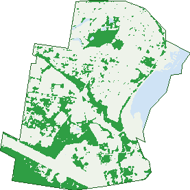
Green: 10 m cells where trees dominate, satellite 2021. Blue: water. The line is the suburb boundary.
| Canopy share, 1 m canopy height map, 2020 | 23.7% |
|---|---|
| Land with trees, 10 m satellite map, 2021 | 29.6% |
Demographics
Unemployment 9.2% · Labour-force participation 41.1%
Population by age in Urangan
| 0-4 | 351 |
|---|---|
| 5-14 | 1,117 |
| 15-19 | 511 |
| 20-24 | 393 |
| 25-34 | 844 |
| 35-44 | 931 |
| 45-54 | 1,224 |
| 55-64 | 1,865 |
| 65-74 | 2,220 |
| 75-84 | 1,202 |
| 85+ | 314 |
Dwelling types in Urangan
| House | 3,462 |
|---|---|
| Townhouse | 761 |
| Apartment | 267 |
| Other | 118 |
Households by weekly income in Urangan
| <$650 | 1,159 |
|---|---|
| $650-1,499 | 1,827 |
| $1,500-2,999 | 951 |
| $3,000+ | 320 |
Top ancestries in Urangan
| English | 5,059 |
|---|---|
| Australian | 3,949 |
| Scottish | 1,201 |
| Irish | 1,168 |
| German | 785 |
| Ancestry NS | 741 |
Housing tenure in Urangan
| Owned | 2,117 |
|---|---|
| Mortgage | 976 |
| Rented | 1,388 |
| Other | 64 |
Cars per household in Urangan
| 0 | 260 |
|---|---|
| 1 | 2,185 |
| 2 | 1,466 |
| 3 | 413 |
| 4+ | 218 |
Commute to work in Urangan
| Car | 2,580 |
|---|---|
| Train | 0 |
| Bus | 19 |
| Tram/ferry | 3 |
| Walked | 93 |
| Bicycle | 53 |
| Home | 279 |
Top countries of birth in Urangan
| England | 686 |
|---|---|
| New Zealand | 424 |
| Philippines | 89 |
| Scotland | 76 |
| South Africa | 74 |
| Netherlands | 72 |
Languages used at home in Urangan
| German | 41 |
|---|---|
| Filipino | 22 |
| Afrikaans | 21 |
| Arabic | 17 |
| French | 17 |
| Tagalog | 16 |
Birds & Wildlife Nearby
14,875 bird observations recorded near Urangan — most often seen:
- Australian White Ibis (1,071)
- Rainbow Lorikeet (830)
- Noisy Miner (819)
- Welcome Swallow (633)
- Pacific Black Duck (614)
- Silver Gull (595)
- Little Black Cormorant (589)
- Crested Tern (568)
- Australian Magpie (530)
- Magpie-lark (527)
- Pied Butcherbird (517)
- Australian Pelican (513)
- Torresian Crow (492)
Show all 30 birds recorded near Urangan
- Dusky Moorhen (488)
- White-faced Heron (452)
- Grey Butcherbird (451)
- Crested Pigeon (439)
- Pied Cormorant (433)
- Australasian Purple Swamphen (407)
- Brahminy Kite (400)
- Little Pied Cormorant (399)
- Australasian Figbird (367)
- Eastern Rainbow Lorikeet (362)
- Australian Wood Duck (359)
- Scaly-breasted Lorikeet (351)
- Caspian Tern (344)
- Spotted Turtle-dove (340)
- Australasian Darter (339)
- Rainbow Bee-eater (330)
- Blue-faced Honeyeater (316)
Sightings reported by observers, not a survey, so the counts show what people record rather than what lives here. Source: Atlas of Living Australia.
Nearby Suburbs
The closest suburbs to Urangan:
Embed this suburb
Add this free Urangan stat card to your own site — just copy the code:
Preview:
Cite this page
Quoting these figures? Copy the credit line:
Keep an eye on Urangan
One email when this data meaningfully changes — new census figures, prices, rankings. No spam, unsubscribe anytime.
Streets
- Adam Court (8)
- Aero Court (1)
- Aero Drive (1)
- Aimee Drive (65)
- Alexander Street (24)
- Alma Court (4)
- Alpsea Avenue (8)
- Arthur Street (17)
- Astro Drive (11)
- Barron Court (18)
- Bayrise Drive (64)
- Beck Road (31)
- Bellero Street (5)
- Bluebonnet Court (7)
- Boat Harbour Drive (242)
- Bonita Court (18)
- Booral Road (63)
- Boundary Road (52)
- Bradman Way (153)
- Braun Court (5)
- Buccaneer Drive (245)
- Burrum Street (12)
- Caringa Street (26)
- Cartwright Court (4)
- Cassandra Crescent (43)
- Cattleya Court (5)
- Chani Close (6)
- Chantilly Street (19)
- Charlton Esplanade (768)
- Chloe Court (7)
- Churchill Street (17)
- Clint Street (4)
- Collare Court (7)
- Connock Street (20)
- Cooloola Crescent (27)
- Coral Street (22)
- Cordelia Court (6)
- Crescent Street (16)
- Crystal Court (33)
- Cunningham Street (94)
- Cypress Street (204)
- Daintree Drive (28)
- Dayman Street (125)
- Debra Court (25)
- Deloraine Avenue (26)
- Diana Place (8)
- Domingo Place (7)
- Don Adams Drive (11)
- Driftwood Court (42)
- Drummond Street (83)
- Eastwood Court (7)
- Edith Street (1)
- Edward Street (38)
- Edwin Street (6)
- Elizabeth Street (659)
- Ellengowan Street (30)
- Emerald Park Way (98)
- Emma Court (4)
- Esplanade (660)
- Felix Court (8)
- Fiona Court (6)
- Florence Street (10)
- Foreshore Drive (42)
- Freeburn Street (1)
- Garden Drive (93)
- Gibbs Street (24)
- Glenray Street (20)
- Greta Court (4)
- Guard Street (4)
- Hamer Drive (30)
- Hammond Street (82)
- Hansen Street (70)
- Harrison Circuit (47)
- Heran Court (8)
- Herbert Street (11)
- Hibiscus Street (124)
- Hockley Lane (21)
- Hood Street (12)
- Hoop Way (3)
- Howard Street (12)
- Howlett Street (12)
- Hughes Road (30)
- Island View Drive (511)
- Jade Court (13)
- James Street (22)
- Jasper Court (7)
- Jennylee Close (14)
- Jetty Street (3)
- Jewel Court (17)
- John Duigan Drive (8)
- Johnson Street (1)
- Jordan Close (12)
- Karina Court (14)
- Kent Street (39)
- King Arthur Court (11)
- King Edward Court (14)
- King Richard Court (12)
- King Street (118)
- Kruger Court (20)
- Ladbroke Crescent (76)
- Laguna Court (10)
- Larimar Court (4)
- Larissa Way (28)
- Larsen Street (6)
- Lauren Street (51)
- Layde Court (24)
- Lido Parade (30)
- Lillee Court (18)
- Limpus Street (118)
- Lucyanne Court (11)
- Margaret Street (39)
- Marine Court (19)
- Marloo Court (8)
- Matthew Drive (18)
- Merlin Drive (41)
- Merrilyn Court (19)
- Mexican Court (13)
- Miller Street (120)
- Mitta Way (2)
- Moolyyir Street (118)
- Moonstone Drive (58)
- Nancy Bird Court (5)
- New Street (7)
- Oceanfront Court (10)
- Opal Way (2)
- Orchid Avenue (38)
- Owen Crescent (19)
- Padre Drive (13)
- Paperbark Way (6)
- Park Street (15)
- Pier Street (55)
- Pilot Street (33)
- Ponting Way (20)
- Prince Street (49)
- Pulgul Street (570)
- Rialto Court (10)
- Richard Street (50)
- Riley Street (10)
- Ringtail Way (11)
- Rita Court (7)
- Robb Court (5)
- Robert Street (7)
- Robertson Street (1)
- Ronaldo Way (51)
- Rosa Court (5)
- Ross Street (16)
- Round Island Road (9)
- San Bromista Court (16)
- San Marco Court (12)
- Sandalan Way (5)
- Sandy Street (4)
- Satinay Street (13)
- Seaspray Court (5)
- Senor Avenue (57)
- Senorita Parade (64)
- Shell Street (163)
- Shore Road E (10)
- Shoreline Court (13)
- Short Street (1)
- Silkwood Drive (40)
- Skinner Crescent (20)
- Skye Court (8)
- Smith Street (18)
- Sonder Street (12)
- South Street (60)
- Southern Cross Circuit (89)
- Stewart Street (14)
- Stringybark Drive (13)
- Sunline Court (11)
- Swaney Court (8)
- Swiss Court (8)
- Taela Court (6)
- Tannen Court (6)
- Tina Drive (56)
- Toni Street (1)
- Topaz Circuit (37)
- Treviso Court (14)
- Trill Court (17)
- Tristania Crescent (47)
- Truro Street (45)
- Turnbull Court (20)
- Twolyn Street (22)
- Vanda Street (44)
- Verden Drive (20)
- Victory East Street (22)
- Vista Street (3)
- Walkers Road (25)
- Wallace Court (8)
- Waugh Street (48)
- Whipbird Court (22)
- Whitaker Court (5)
- Whitby Street (5)
- Whittaker Close (5)
- Whittaker Place (5)
- William Dean Avenue (14)
- William Street (53)
- Wyuna Court (12)
- Zircon Street (6)