Upper Kedron QLD 4055
2,465 addresses · 121 streets
Ryan Electorate › Brisbane LGA › Upper Kedron · 12 km from Brisbane
📦 Thinking of moving here? Read the Upper Kedron moving guide

Living Here
Upper Kedron is a suburb of Queensland, home to about 5,800 people, with a median age of 34. The typical household earns around $2,980 a week, with median rent near $455 a week. Most homes are houses. About 73% of households own their home and 27% rent. Most workers drive to work. Common community backgrounds include Australian, English, Irish. On the ABS socio-economic scale it sits in decile 10 of 10 nationally — a relatively advantaged area.
Over time — Census 2001 → 2021
Dashed line: district figures for the Upper Kedron - Ferny Grove statistical area (SA2), the smallest area the ABS published before 2011. Solid line: Upper Kedron itself.
Getting Around & Local Services
3 supermarkets
10 Catholic churches
2 pharmacies
2 doctors & medical clinics
1 optometrist
2 golf clubs
1 playground
2 dog parks
2 bakeries
2 hardware stores
2 hairdressers
1 mechanic
1 carpenter
1 place to stay
Getting around. Train station: Ferny Grove, 2.5 km north-east · Bus interchange: The Gap park 'n' ride, 3.2 km south · Airport: Brisbane Airport, 20.5 km east.
Socio-economic Standing
Deciles from 1 (lowest) to 10 (highest), against all Australian suburbs. The overall figure weighs advantage and disadvantage together; economic resources counts income and housing, and education & jobs counts qualifications and occupation. They often differ. Source: ABS SEIFA 2021.
Tree cover
🌳 Tree canopy: 53.9% share of land under canopy · satellite map, 2020
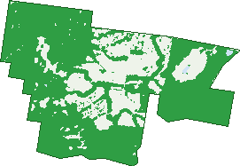
Green: 10 m cells where trees dominate, satellite 2021. Blue: water. The line is the suburb boundary.
| Canopy share, 1 m canopy height map, 2020 | 53.9% |
|---|---|
| Land with trees, 10 m satellite map, 2021 | 74.4% |
Demographics
Unemployment 3.7% · Labour-force participation 77.9%
Population by age in Upper Kedron
| 0-4 | 481 |
|---|---|
| 5-14 | 1,120 |
| 15-19 | 429 |
| 20-24 | 242 |
| 25-34 | 720 |
| 35-44 | 1,102 |
| 45-54 | 898 |
| 55-64 | 415 |
| 65-74 | 255 |
| 75-84 | 108 |
| 85+ | 25 |
Dwelling types in Upper Kedron
| House | 1,774 |
|---|---|
| Townhouse | 0 |
| Apartment | 0 |
| Other | 0 |
Households by weekly income in Upper Kedron
| <$650 | 69 |
|---|---|
| $650-1,499 | 194 |
| $1,500-2,999 | 571 |
| $3,000+ | 823 |
Top ancestries in Upper Kedron
| Australian | 2,400 |
|---|---|
| English | 2,335 |
| Irish | 698 |
| Scottish | 652 |
| Other | 612 |
| German | 342 |
Housing tenure in Upper Kedron
| Owned | 342 |
|---|---|
| Mortgage | 947 |
| Rented | 472 |
| Other | 8 |
Cars per household in Upper Kedron
| 0 | 7 |
|---|---|
| 1 | 366 |
| 2 | 1,011 |
| 3 | 262 |
| 4+ | 125 |
Commute to work in Upper Kedron
| Car | 1,709 |
|---|---|
| Train | 92 |
| Bus | 4 |
| Tram/ferry | 0 |
| Walked | 15 |
| Bicycle | 12 |
| Home | 750 |
Top countries of birth in Upper Kedron
| England | 236 |
|---|---|
| New Zealand | 148 |
| South Africa | 120 |
| India | 116 |
| Scotland | 46 |
| China | 39 |
Languages used at home in Upper Kedron
| Mandarin | 59 |
|---|---|
| Spanish | 52 |
| Afrikaans | 43 |
| Hindi | 34 |
| Portuguese | 28 |
| French | 27 |
Birds & Wildlife Nearby
86,755 bird observations recorded near Upper Kedron — most often seen:
- Sulphur-crested Cockatoo (5,155)
- Rainbow Lorikeet (4,623)
- Torresian Crow (4,588)
- Noisy Miner (4,422)
- Lewin's Honeyeater (4,022)
- Pied Currawong (3,729)
- Laughing Kookaburra (3,717)
- Eastern Whipbird (3,388)
- Australian Brush-turkey (3,221)
- Australian Magpie (3,084)
- Grey Butcherbird (2,781)
- Pacific Black Duck (2,656)
- Striated Pardalote (2,561)
Show all 30 birds recorded near Upper Kedron
- Welcome Swallow (2,527)
- Noisy Friarbird (2,524)
- Eastern Yellow Robin (2,497)
- Scarlet Honeyeater (2,471)
- Yellow-faced Honeyeater (2,470)
- Dusky Moorhen (2,397)
- Willie Wagtail (2,362)
- Australian King-parrot (2,355)
- Scaly-breasted Lorikeet (2,336)
- Australasian Figbird (2,251)
- Grey Shrike-thrush (2,173)
- Grey Fantail (2,111)
- Black-faced Cuckoo-shrike (2,086)
- Pied Butcherbird (2,085)
- Spangled Drongo (2,084)
- White-throated Treecreeper (2,058)
- Olive-backed Oriole (2,021)
Sightings reported by observers, not a survey, so the counts show what people record rather than what lives here. Source: Atlas of Living Australia.
Nearby Suburbs
The closest suburbs to Upper Kedron:
- Ferny Grove (2 km)
- Keperra (3.4 km)
- Enoggera Reservoir (3.5 km)
- Ferny Hills (3.5 km)
- The Gap (3.7 km)
- Camp Mountain (4.6 km)
- Arana Hills (4.6 km)
- Mitchelton (5.3 km)
Embed this suburb
Add this free Upper Kedron stat card to your own site — just copy the code:
Preview:
Cite this page
Quoting these figures? Copy the credit line:
Keep an eye on Upper Kedron
One email when this data meaningfully changes — new census figures, prices, rankings. No spam, unsubscribe anytime.
Streets
- Aberdeen Place (30)
- Albatross Street (19)
- Alex Close (5)
- Ancaster Road (17)
- Arris Close (7)
- Ascent Street (25)
- Avalon Place (19)
- Bauple Close (9)
- Bendigo Place (43)
- Brockman Drive (65)
- Brockman Street (1)
- Brompton Road (1)
- Budgerigar Street (28)
- Butlers Close (11)
- Canvey Road (84)
- Cascade Place (22)
- Cedar Creek Road (54)
- Cemetery Road (4)
- Central Street (21)
- Charolais Crescent (59)
- Cockatoo Street (5)
- Columbia Close (9)
- Conway Street (7)
- Curlew Street (18)
- Dale Court (3)
- Drovers Street (16)
- Dundee Place (15)
- Edinburgh Close (12)
- Edward Close (11)
- Egret Street (14)
- Ellie Court (6)
- Endeavor Street (1)
- Endeavour Street (17)
- Ferndale Place (23)
- Fitzgerald Place (18)
- Flagstaff Place (11)
- Flinders Street (25)
- Forbes Crescent (18)
- Fortis Crescent (20)
- Glenkyree Close (8)
- Glentryst Court (5)
- Goshawk Street (12)
- Halifax Street (21)
- Hall Court (5)
- Harrier Place (20)
- Hasties Avenue (19)
- Highbury Place (14)
- Holbourne Street (17)
- Honeybee Place (13)
- Honeyeater Street (23)
- Inverary Place (20)
- Inverness Street (67)
- Jervis Street (7)
- Julatten Place (35)
- Karvella Street (40)
- Kathdan Close (11)
- Kilkenny Close (5)
- Kingfisher Drive (47)
- Kirralee Crescent (134)
- Kosciuszko Street (33)
- Kulnura Street (9)
- Kyeamba Close (11)
- Kyndalyn Close (10)
- Levitt Road (33)
- Lincoln Crescent (31)
- Lochern Place (44)
- Lochinvar Road (28)
- Lomond Circuit (49)
- Lorikeet Street (13)
- Lyrebird Crescent (31)
- Magpie Place (18)
- Mckinnon Court (9)
- Millwood Place (10)
- Minnie Street (1)
- Monsato Close (12)
- Narkoola Street (2)
- Nyamber Place (10)
- Nyngarie Place (11)
- O'quinn Street (34)
- Oaklands Place (15)
- Oquinn Road (27)
- Osprey Place (16)
- Palmerston Close (15)
- Panorama Place (21)
- Paradise Place (12)
- Parksedge Street (14)
- Parkwater Close (13)
- Pickering Place (29)
- Pine Place (30)
- Porcupine Lane (5)
- Prospect Place (15)
- Reynella Close (11)
- Ridge Place (12)
- Rise Place (15)
- Ronald Close (10)
- Rosella Street (6)
- Ross Road (38)
- Sanctuary Place (13)
- Sandpiper Place (1)
- Sandpiper Street (2)
- Saunders Close (13)
- Seeana Court (5)
- Selkirk Crescent (16)
- Skye Place (32)
- Springbrook Close (10)
- Strathmere Place (31)
- Stuart Place (1)
- Sturt Place (12)
- Sundown Circuit (40)
- Tallimba Street (11)
- Taunton Circuit (77)
- Thomas Place (22)
- Toolman Circuit (1)
- Tooloom Circuit (39)
- Trevallyn Place (29)
- Trossachs Place (6)
- Upper Kedron Road (10)
- Valley Place (13)
- Wagtail Street (15)
- Windsor Drive (40)
- Wyellan Place (27)