Underwood QLD 4119
4,172 addresses · 140 streets
Rankin Electorate › Logan LGA › Underwood · 17 km from Brisbane
📦 Thinking of moving here? Read the Underwood moving guide

Living Here
Underwood is a suburb of Queensland, home to about 6,809 people, with a median age of 34. The typical household earns around $1,992 a week, with median rent near $400 a week. Most homes are houses. About 72% of households own their home and 28% rent. Most workers drive to work. Common community backgrounds include English, Australian, Chinese. On the ABS socio-economic scale it sits in decile 8 of 10 nationally — a relatively advantaged area.
Over time — Census 2001 → 2021
Dashed line: district figures for the Underwood statistical area (SA2), the smallest area the ABS published before 2011. Solid line: Underwood itself.
Getting Around & Local Services
3 Catholic churches
4 physiotherapists
3 optometrists
11 childcare & kindergartens
- Hatchlings Early Learning Centre
- Rochedale Central Childcare
- Seedlings Early Learning Rochedale
- Springwood Early Education Centre
- Bright Future Early Education Centre
- Springwood Community Kindergarten
- Goodstart Early Learning Slacks Creek
- Pafrey Road Child Care
- Rochedale Kids Early Learning Centre
- Sunkids Eight Mile Plains
2 post offices
2 golf clubs
2 playgrounds
3 beauty salons
3 electricians
1 plumber
Getting around. Train station: Kuraby, 2 km west · Bus interchange: Springwood station, 1.6 km south-east · Airport: Brisbane Airport, 25.3 km north.
Socio-economic Standing
Deciles from 1 (lowest) to 10 (highest), against all Australian suburbs. The overall figure weighs advantage and disadvantage together; economic resources counts income and housing, and education & jobs counts qualifications and occupation. They often differ. Source: ABS SEIFA 2021.
Tree cover
🌳 Tree canopy: 11.4% share of land under canopy · satellite map, 2020
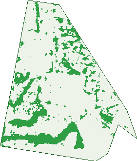
Green: 10 m cells where trees dominate, satellite 2021. Blue: water. The line is the suburb boundary.
| Canopy share, 1 m canopy height map, 2020 | 11.4% |
|---|---|
| Land with trees, 10 m satellite map, 2021 | 18.5% |
Demographics
Unemployment 6.5% · Labour-force participation 67.8%
Population by age in Underwood
| 0-4 | 482 |
|---|---|
| 5-14 | 1,072 |
| 15-19 | 439 |
| 20-24 | 442 |
| 25-34 | 1,053 |
| 35-44 | 1,132 |
| 45-54 | 869 |
| 55-64 | 626 |
| 65-74 | 458 |
| 75-84 | 192 |
| 85+ | 37 |
Dwelling types in Underwood
| House | 1,808 |
|---|---|
| Townhouse | 298 |
| Apartment | 30 |
| Other | 0 |
Households by weekly income in Underwood
| <$650 | 230 |
|---|---|
| $650-1,499 | 539 |
| $1,500-2,999 | 730 |
| $3,000+ | 524 |
Top ancestries in Underwood
| Other | 1,659 |
|---|---|
| English | 1,346 |
| Australian | 1,259 |
| Chinese | 958 |
| Indian | 759 |
| Ancestry NS | 351 |
Housing tenure in Underwood
| Owned | 499 |
|---|---|
| Mortgage | 1,017 |
| Rented | 585 |
| Other | 11 |
Cars per household in Underwood
| 0 | 45 |
|---|---|
| 1 | 599 |
| 2 | 982 |
| 3 | 296 |
| 4+ | 204 |
Commute to work in Underwood
| Car | 2,306 |
|---|---|
| Train | 14 |
| Bus | 88 |
| Tram/ferry | 0 |
| Walked | 41 |
| Bicycle | 8 |
| Home | 427 |
Top countries of birth in Underwood
| India | 451 |
|---|---|
| China | 280 |
| South Korea | 267 |
| New Zealand | 243 |
| Taiwan | 141 |
| South Africa | 134 |
Languages used at home in Underwood
| Mandarin | 529 |
|---|---|
| Punjabi | 418 |
| Korean | 336 |
| Cantonese | 257 |
| Hindi | 165 |
| Urdu | 162 |
Birds & Wildlife Nearby
25,130 bird observations recorded near Underwood — most often seen:
- Noisy Miner (1,806)
- Rainbow Lorikeet (1,624)
- Laughing Kookaburra (1,502)
- Torresian Crow (1,457)
- Australian Magpie (1,284)
- Australian White Ibis (1,096)
- Dusky Moorhen (973)
- Grey Butcherbird (912)
- Australian Wood Duck (903)
- Pacific Black Duck (838)
- Pied Butcherbird (807)
- Australian Brush-turkey (805)
- Sulphur-crested Cockatoo (775)
Show all 30 birds recorded near Underwood
- Crested Pigeon (740)
- Pied Currawong (740)
- Willie Wagtail (736)
- Welcome Swallow (724)
- Magpie-lark (704)
- Black-faced Cuckoo-shrike (661)
- Tawny Frogmouth (610)
- Striated Pardalote (606)
- Scaly-breasted Lorikeet (595)
- Noisy Friarbird (572)
- Australian Torresian Crow (568)
- Pale-headed Rosella (535)
- Eastern Rainbow Lorikeet (526)
- Australasian Figbird (524)
- Brown Honeyeater (511)
- Southern Masked Lapwing (499)
- Green Figbird (497)
Sightings reported by observers, not a survey, so the counts show what people record rather than what lives here. Source: Atlas of Living Australia.
Nearby Suburbs
The closest suburbs to Underwood:
- Kuraby (1.5 km)
- Rochedale South (2.1 km)
- Woodridge (2.4 km)
- Karawatha (2.6 km)
- Springwood (2.8 km)
- Runcorn (3.6 km)
- Eight Mile Plains (3.7 km)
- Slacks Creek (3.8 km)
Embed this suburb
Add this free Underwood stat card to your own site — just copy the code:
Preview:
Cite this page
Quoting these figures? Copy the credit line:
Keep an eye on Underwood
One email when this data meaningfully changes — new census figures, prices, rankings. No spam, unsubscribe anytime.
Streets
- Algia Crescent (31)
- Amberdale Court (5)
- Ameera Court (5)
- Arlington Street (38)
- Ashbrook Place (6)
- Athlone Close (10)
- Avondale Street (14)
- Ballymore Court (5)
- Balmain Street (7)
- Bambara Street (5)
- Bargara Street (15)
- Barton Street (12)
- Beenleigh Road (6)
- Belange Close (6)
- Belgrave Street (20)
- Bella Vista Boulevard (10)
- Belleview Place (13)
- Bernice Avenue (116)
- Botanical Drive (22)
- Brenda Court (7)
- Brierbank Street (25)
- Brine Place (17)
- Brockmia Close (13)
- Brookvale Drive (211)
- Caloma Street (58)
- Camelot Street (18)
- Camrose Crescent (29)
- Carfrae Avenue (19)
- Cascade Drive (132)
- Cedar Lane (5)
- Celia Street (1)
- Centenial Street (17)
- Charlane Street (14)
- Chase Close (43)
- Compton Road (19)
- Coolana Street (28)
- Cristaldi Avenue (55)
- Curban Street (16)
- Darnick Street (61)
- Diana Street (24)
- Dindi Street (27)
- Dorinda Crescent (20)
- Drogheda Close (13)
- Dulaca Street (15)
- Edenvale Street (16)
- Edward Street (12)
- Eileen Street (13)
- Elayne Street (7)
- Eleanor Avenue (20)
- Elisa Avenue (23)
- Ellis Place (16)
- Ericvale Place (12)
- Erminio Way (5)
- Ewing Road (18)
- Fairmont Crescent (35)
- Fairymead Street (23)
- Farzana Place (25)
- Ferguson Street (41)
- Fermont Road (90)
- Francesca Court (19)
- Gardross Close (10)
- Gebacri Road (17)
- Glebe Place (13)
- Glencoe Court (15)
- Glenview Court (21)
- Glindemann Drive (11)
- Graham Street (17)
- Gunalda Street (32)
- Gunn Street (15)
- Harris Road (74)
- Iceberg Avenue (20)
- Inverness Street (27)
- Jagfed Road (21)
- Joanne Street (28)
- Juliana Court (13)
- Kakadu Crescent (22)
- Katelyn Street (20)
- Kenway Drive (52)
- Ketter Place (25)
- Kettniss Street (17)
- Kingston Road (175)
- Lapis Street (22)
- Leila Street (11)
- Lemrak Street (6)
- Lexington Road (4)
- Lima Court (25)
- Logan Road (538)
- Louise Street (64)
- Lowmead Street (16)
- Madanie Crescent (18)
- Malena Way (6)
- Malone Place (13)
- Maureen Street (10)
- Millers Road (28)
- Mowie Close (15)
- Murcot Street (39)
- Nancy Street (15)
- Nerissa Court (7)
- Nevilles Street (44)
- Nicholas Court (8)
- Oakvale Street (24)
- Paisley Place (13)
- Parkland Avenue (9)
- Parramatta Road (125)
- Pele Court (8)
- Penrhyn Place (17)
- Penrose Close (6)
- Perrin Drive (42)
- Pomeroy Close (7)
- Reid Place (6)
- Ridgewood Street (17)
- Rigney Street (10)
- Rio Court (19)
- Rolfe Circuit (32)
- Rosemont Court (30)
- Samba Place (44)
- Simon Street (29)
- Smallwood Street (81)
- Southwalk Esplanade (19)
- Sports Drive (12)
- Springvale Circuit (76)
- Springwood Road (31)
- Stegemann Road (12)
- Suffolk Court (12)
- Sylvia Street (21)
- The Concourse (27)
- The Crescent (50)
- The Enclave (8)
- The Glade (9)
- The Grove (8)
- The Heights (39)
- The Nook (8)
- The Rise (11)
- The Terrace (9)
- Tintagel Street (28)
- Torville Road (32)
- Turnock Court (12)
- Underwood Road (36)
- Welch Street (30)
- Zuleikha Drive (21)