Tannum Sands QLD 4680
2,643 addresses · 127 streets
Flynn Electorate › Gladstone LGA › Tannum Sands · 425 km from Brisbane
📦 Thinking of moving here? Read the Tannum Sands moving guide

Living Here
Tannum Sands is a suburb of Queensland, home to about 5,227 people, with a median age of 41. The typical household earns around $2,035 a week, with median rent near $290 a week. Most homes are houses. About 69% of households own their home and 31% rent. Most workers drive to work. Common community backgrounds include English, Australian, Scottish. On the ABS socio-economic scale it sits in decile 5 of 10 nationally — a mid-range area.
Over time — Census 2001 → 2021
Dashed line: district figures for the Boyne Island - Tannum Sands statistical area (SA2), the smallest area the ABS published before 2011. Solid line: Tannum Sands itself.
Getting Around & Local Services
2 cafés & restaurants
2 supermarkets
2 beaches
1 medical clinic
1 hospital
1 library
2 service stations
1 playground
1 bakery
1 butcher
2 places to stay
Getting around. Airport: Gladstone Airport, 17.4 km north-west.
Socio-economic Standing
Deciles from 1 (lowest) to 10 (highest), against all Australian suburbs. The overall figure weighs advantage and disadvantage together; economic resources counts income and housing, and education & jobs counts qualifications and occupation. They often differ. Source: ABS SEIFA 2021.
Tree cover
🌳 Tree canopy: 55.8% share of land under canopy · satellite map, 2020
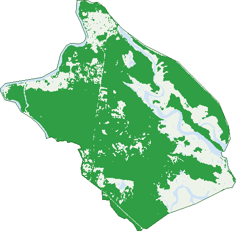
Green: 10 m cells where trees dominate, satellite 2021. Blue: water. The line is the suburb boundary.
| Canopy share, 1 m canopy height map, 2020 | 55.8% |
|---|---|
| Land with trees, 10 m satellite map, 2021 | 73.1% |
Demographics
Unemployment 5.8% · Labour-force participation 66.5%
Population by age in Tannum Sands
| 0-4 | 269 |
|---|---|
| 5-14 | 862 |
| 15-19 | 395 |
| 20-24 | 196 |
| 25-34 | 474 |
| 35-44 | 711 |
| 45-54 | 891 |
| 55-64 | 778 |
| 65-74 | 449 |
| 75-84 | 173 |
| 85+ | 44 |
Dwelling types in Tannum Sands
| House | 1,581 |
|---|---|
| Townhouse | 142 |
| Apartment | 164 |
| Other | 9 |
Households by weekly income in Tannum Sands
| <$650 | 264 |
|---|---|
| $650-1,499 | 407 |
| $1,500-2,999 | 552 |
| $3,000+ | 513 |
Top ancestries in Tannum Sands
| English | 2,230 |
|---|---|
| Australian | 2,101 |
| Scottish | 641 |
| Irish | 600 |
| German | 377 |
| Other | 332 |
Housing tenure in Tannum Sands
| Owned | 535 |
|---|---|
| Mortgage | 747 |
| Rented | 571 |
| Other | 18 |
Cars per household in Tannum Sands
| 0 | 44 |
|---|---|
| 1 | 580 |
| 2 | 801 |
| 3 | 301 |
| 4+ | 145 |
Commute to work in Tannum Sands
| Car | 1,870 |
|---|---|
| Train | 0 |
| Bus | 6 |
| Tram/ferry | 4 |
| Walked | 66 |
| Bicycle | 20 |
| Home | 142 |
Top countries of birth in Tannum Sands
| New Zealand | 248 |
|---|---|
| England | 165 |
| South Africa | 122 |
| Scotland | 36 |
| United States | 25 |
| Ireland | 18 |
Languages used at home in Tannum Sands
| Afrikaans | 48 |
|---|---|
| Spanish | 20 |
| Italian | 9 |
| Thai | 9 |
| German | 8 |
| Urdu | 8 |
Birds & Wildlife Nearby
5,033 bird observations recorded near Tannum Sands — most often seen:
- Rainbow Bee-eater (270)
- Torresian Crow (264)
- Rainbow Lorikeet (227)
- Laughing Kookaburra (222)
- Australasian Figbird (221)
- Lewin's Honeyeater (210)
- Bar-shouldered Dove (208)
- Varied Triller (202)
- Australian Wood Duck (188)
- Peaceful Dove (187)
- Brown Honeyeater (179)
- Little Friarbird (179)
- Welcome Swallow (169)
Show all 30 birds recorded near Tannum Sands
- Pacific Black Duck (160)
- Australasian Purple Swamphen (159)
- Brahminy Kite (155)
- Double-barred Finch (148)
- Dusky Moorhen (147)
- Blue-winged Kookaburra (144)
- Australian White Ibis (139)
- Spangled Drongo (137)
- Eastern Rainbow Lorikeet (136)
- Australian Magpie (130)
- Black-faced Cuckoo-shrike (130)
- Australian Brush-turkey (125)
- Leaden Flycatcher (125)
- Australian Torresian Crow (121)
- Australian Pied Oystercatcher (118)
- Willie Wagtail (117)
- Dollarbird (116)
Sightings reported by observers, not a survey, so the counts show what people record rather than what lives here. Source: Atlas of Living Australia.
Nearby Suburbs
The closest suburbs to Tannum Sands:
- Boyne Island (2.2 km)
- Wurdong Heights (7.5 km)
- Benaraby (7.7 km)
- South Trees (10 km)
- O'connell (10.8 km)
- Glen Eden (11.5 km)
- Toolooa (12.8 km)
- Telina (13.9 km)
Embed this suburb
Add this free Tannum Sands stat card to your own site — just copy the code:
Preview:
Cite this page
Quoting these figures? Copy the credit line:
Keep an eye on Tannum Sands
One email when this data meaningfully changes — new census figures, prices, rankings. No spam, unsubscribe anytime.
Streets
- Alfred Street (36)
- Aluminium Drive (24)
- Amanda Court (5)
- Anchor Street (19)
- Applin Place (12)
- Ariel Lane (14)
- Aurora Road (51)
- Balmain Court (5)
- Bamba Street (8)
- Beach Avenue (64)
- Bevington Street (53)
- Blackwell Street (39)
- Booth Avenue (93)
- Bosun Circuit (8)
- Broadacres Drive (60)
- Bruce Highway (6)
- Buckley Court (4)
- Bulimba Street (33)
- Caledon Street (18)
- Cambridge Close (11)
- Canoe Point Road (1)
- Capstan Place (3)
- Capston Place (3)
- Charles Crescent (7)
- Chelsea Lane (4)
- Clearview Court (7)
- Cloncurry Court (7)
- Coal Crescent (14)
- Cobalt Crescent (15)
- Colyer Avenue (5)
- Copper Crescent (8)
- Coral Street (12)
- Coronation Drive (8)
- Creek Road (32)
- Cremorne Drive (86)
- Cressey Court (4)
- Creswell Court (12)
- Dahl Road (7)
- Darragh Street (13)
- Delaney Court (9)
- Denchley Street (4)
- Di Street (3)
- Diamond Crescent (9)
- Donald Street (19)
- Douglas Street (24)
- Dr John Mcgree Esplanade (2)
- Driftwood Street (16)
- Drummond Court (9)
- Dunn Street (18)
- Elizabeth Street (37)
- Forsyth Court (7)
- Fox Court (7)
- Francis Way (1)
- Garnet Street (23)
- Gately Court (4)
- Geoffrey Thomas Drive (53)
- Glenville Street (6)
- Golden Avenue (26)
- Graham Street (12)
- Gregory Street (10)
- Groper Street (9)
- Gwen Street (18)
- Hampton Drive (143)
- Hoddinott Close (7)
- Island View Court (4)
- Jacinta Court (11)
- Jenkinson Street (8)
- Karumba Court (13)
- Keating Street (53)
- Keel Street (9)
- Kerfoot Close (10)
- Kirkdale Street (13)
- Kylie Maree Court (4)
- Langdon Street (58)
- Lark Court (1)
- Latrobe Street (86)
- Lawrence Court (8)
- Linda Street (17)
- Longreach Court (38)
- Macedon Street (32)
- Madigan Road (21)
- Margaret Street (27)
- Marine Avenue (15)
- Marloo Drive (44)
- Marquis Court (14)
- Millenium Esplanade (1)
- Myer Court (4)
- Neptune Street (13)
- Ocean Street (53)
- Old Tannum Road (4)
- Onslow Street (3)
- Pacific Avenue (66)
- Parkside Street (52)
- Phillip Street (2)
- Pleasant Avenue (31)
- Plimsoll Court (27)
- Prestige Close (13)
- Pryde Street (42)
- Ridge Close (12)
- Riverside Drive (31)
- Ronpen Close (16)
- Salmon Street (5)
- Scallop Street (32)
- School Street (16)
- Schooner Street (23)
- Selina Court (7)
- Selma Court (21)
- Silica Road (4)
- Silverton Drive (73)
- Steel Street (12)
- Stephens Court (7)
- Stern Road (4)
- Stoney Court (14)
- Strauss Court (4)
- Tannum Sands Road (18)
- The Oaks Road (58)
- Tiller Street (4)
- Timbertop Court (6)
- Tina Drive (17)
- Trevally Street (14)
- Trochus Street (8)
- Tyson Crescent (44)
- Waratah Crescent (24)
- Wedge Street (27)
- Winnecke Road (32)
- Yacht Road (15)
- Zephyr Street (11)