Surfers Paradise QLD 4217
36,178 addresses · 127 streets
Moncrieff Electorate › Gold Coast LGA › Surfers Paradise · 71 km from Brisbane
📦 Thinking of moving here? Read the Surfers Paradise moving guide

Living Here
A high-rise beachfront hub on the Gold Coast, Surfers Paradise mixes permanent residents with a strong holiday-letting market. The median age is 42 and households average 1.9 people, typical of its apartment towers. Median household income is $1,323 a week and rent about $410.
Surfers Paradise is a suburb of Queensland, home to about 26,412 people, with a median age of 42. The typical household earns around $1,323 a week, with median rent near $410 a week. Most homes are apartments. About 46% of households own their home and 52% rent. Most workers drive to work. Common community backgrounds include English, Australian, Ancestry NS. On the ABS socio-economic scale it sits in decile 6 of 10 nationally — a mid-range area.
Over time — Census 2001 → 2021
Dashed line: district figures for the Surfers Paradise statistical area (SA2), the smallest area the ABS published before 2011. Solid line: Surfers Paradise itself.
Getting Around & Local Services
13 doctors & medical clinics
- My Doctors Clinic Surfers Paradise
- Sullivan Nicolaides Pathology
- Evendale Practice
- Vitality Unleashed Psychology
- My Green Medical
- Broadbeach Waters Medical Centre
- Bundall Medical Centre
- Ashbury Cosmetics Gold Coast
- Australian Skin Cancer Clinics
- Gold Coast Dermatology Clinic
See all 13 doctors & medical clinics near Surfers Paradise →
2 optometrists
2 libraries
1 dog park
2 butchers
2 hardware stores
2 electricians
Getting around. Train station: Nerang, 7.7 km west · Light rail stop: Cavill Avenue, 150 m north-east · Bus interchange: Greyhound Bus Terminal Surfers Paradise, 100 m south-west · Ferry wharf: Surfers Paradise Ferry Terminal, 250 m north-west · Airport: Southport Flying Club, 10.4 km north-west.
Socio-economic Standing
Deciles from 1 (lowest) to 10 (highest), against all Australian suburbs. The overall figure weighs advantage and disadvantage together; economic resources counts income and housing, and education & jobs counts qualifications and occupation. They often differ. Source: ABS SEIFA 2021.
Tree cover
🌳 Tree canopy: 7% share of land under canopy · satellite map, 2020
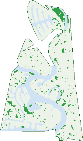
Green: 10 m cells where trees dominate, satellite 2021. Blue: water. The line is the suburb boundary.
| Canopy share, 1 m canopy height map, 2020 | 7.0% |
|---|---|
| Land with trees, 10 m satellite map, 2021 | 4.1% |
Demographics
Unemployment 7.1% · Labour-force participation 55.7%
Population by age in Surfers Paradise
| 0-4 | 767 |
|---|---|
| 5-14 | 1,298 |
| 15-19 | 795 |
| 20-24 | 2,058 |
| 25-34 | 5,658 |
| 35-44 | 3,446 |
| 45-54 | 3,239 |
| 55-64 | 3,462 |
| 65-74 | 3,345 |
| 75-84 | 1,881 |
| 85+ | 469 |
Dwelling types in Surfers Paradise
| House | 1,147 |
|---|---|
| Townhouse | 842 |
| Apartment | 9,277 |
| Other | 45 |
Households by weekly income in Surfers Paradise
| <$650 | 2,272 |
|---|---|
| $650-1,499 | 3,784 |
| $1,500-2,999 | 3,087 |
| $3,000+ | 1,535 |
Top ancestries in Surfers Paradise
| English | 8,049 |
|---|---|
| Australian | 5,246 |
| Other | 4,820 |
| Ancestry NS | 3,631 |
| Irish | 2,361 |
| Scottish | 2,175 |
Housing tenure in Surfers Paradise
| Owned | 3,060 |
|---|---|
| Mortgage | 2,082 |
| Rented | 5,850 |
| Other | 158 |
Cars per household in Surfers Paradise
| 0 | 1,486 |
|---|---|
| 1 | 6,015 |
| 2 | 2,763 |
| 3 | 558 |
| 4+ | 313 |
Commute to work in Surfers Paradise
| Car | 6,686 |
|---|---|
| Train | 103 |
| Bus | 151 |
| Tram/ferry | 466 |
| Walked | 1,054 |
| Bicycle | 182 |
| Home | 1,747 |
Top countries of birth in Surfers Paradise
| New Zealand | 1,585 |
|---|---|
| Brazil | 1,050 |
| England | 1,040 |
| India | 797 |
| Philippines | 362 |
| Japan | 336 |
Languages used at home in Surfers Paradise
| Portuguese | 998 |
|---|---|
| Spanish | 814 |
| Mandarin | 483 |
| Japanese | 374 |
| Punjabi | 338 |
| Nepali | 289 |
Birds & Wildlife Nearby
28,078 bird observations recorded near Surfers Paradise — most often seen:
- Australian White Ibis (2,011)
- Rainbow Lorikeet (1,825)
- Noisy Miner (1,740)
- Welcome Swallow (1,426)
- Silver Gull (1,376)
- Pied Currawong (1,375)
- Torresian Crow (1,323)
- Australian Magpie (1,311)
- Magpie-lark (1,141)
- Rock Dove (994)
- Pied Butcherbird (943)
- Crested Pigeon (891)
- Masked Lapwing (878)
Show all 30 birds recorded near Surfers Paradise
- Pacific Black Duck (876)
- Dusky Moorhen (836)
- Australasian Purple Swamphen (817)
- Little Black Cormorant (809)
- Grey Butcherbird (735)
- Australian Wood Duck (666)
- Little Pied Cormorant (628)
- Black Swan (624)
- Common Myna (596)
- Blue-faced Honeyeater (583)
- Australasian Grebe (574)
- Australasian Figbird (564)
- Eurasian Coot (545)
- Australian Pelican (533)
- Bush Stone-curlew (516)
- Willie Wagtail (473)
- Scaly-breasted Lorikeet (469)
Sightings reported by observers, not a survey, so the counts show what people record rather than what lives here. Source: Atlas of Living Australia.
Nearby Suburbs
The closest suburbs to Surfers Paradise:
- Bundall (2.2 km)
- Main Beach (2.7 km)
- Broadbeach (2.9 km)
- Broadbeach Waters (3 km)
- Southport (4.1 km)
- Benowa (4.2 km)
- Ashmore (5 km)
- Mermaid Waters (5.1 km)
Embed this suburb
Add this free Surfers Paradise stat card to your own site — just copy the code:
Preview:
Cite this page
Quoting these figures? Copy the credit line:
Keep an eye on Surfers Paradise
One email when this data meaningfully changes — new census figures, prices, rankings. No spam, unsubscribe anytime.
Streets
- Acacia Avenue (24)
- Admiralty Drive (969)
- Adori Street (90)
- Alberta Place (3)
- Alison Street (23)
- Amalfi Drive (125)
- Anembo Street (123)
- Appel Street (66)
- Aruma Street (61)
- Aubrey Street (305)
- Barranbali Street (70)
- Beach Parade (368)
- Beach Road (53)
- Bimbi Court (3)
- Birt Avenue (42)
- Blondell Avenue (21)
- Brindisi Avenue (46)
- Buccaneer Court (35)
- Bundall Road (93)
- Burra Street (231)
- Cambridge Road (16)
- Cannes Avenue (286)
- Castille Court (7)
- Cavill Avenue (607)
- Clifford Street (352)
- Commodore Drive (450)
- Crombie Avenue (15)
- Cypress Avenue (334)
- Dalpura Street (186)
- Darrambal Street (368)
- Elkhorn Avenue (162)
- Elliott Street (235)
- Enderley Avenue (714)
- Esplanade (2,125)
- Esther Place (18)
- Etna Street (23)
- Fern Street (234)
- Ferny Avenue (2,224)
- Fiesta Avenue (13)
- First Avenue (48)
- Florence Court (9)
- Frederick Street (104)
- Garfield Terrace (263)
- Genoa Street (136)
- Gibraltar Drive (86)
- Gold Coast Highway (2,552)
- Hamilton Avenue (619)
- Hanlan Street (602)
- Higman Street (57)
- Holborow Close (53)
- Illawong Street (122)
- Inga Avenue (50)
- Kalyan Street (23)
- Karloo Street (5)
- La Scala Court (14)
- La Spezia Court (20)
- Laycock Street (334)
- Leonard Avenue (194)
- Main Beach Parade (373)
- Mallana Street (70)
- Margharita Place (2)
- Markwell Avenue (162)
- Mawarra Street (90)
- Maxime Court (6)
- Midshipman Court (32)
- Milan Court (7)
- Monaco Street (301)
- Monte Carlo Avenue (126)
- Naples Avenue (31)
- Neptune Court (20)
- Norfolk Avenue (319)
- Norseman Court (43)
- Northcliffe Terrace (536)
- Oak Avenue (82)
- Ocean Avenue (123)
- Old Burleigh Road (1,735)
- Orchid Avenue (976)
- Ouyan Street (4)
- Palm Avenue (548)
- Paradise Island (635)
- Paradise Place (29)
- Parneno Street (84)
- Parnoo Street (46)
- Peninsular Drive (646)
- Pine Avenue (90)
- Pisa Court (27)
- Purli Street (180)
- Rapallo Avenue (51)
- Remembrance Drive (274)
- Remo Street (23)
- River Drive (96)
- River Terrace (28)
- Riverview Parade (350)
- Rylie Street (14)
- Saint Andrews Avenue (44)
- Saint Pauls Place (10)
- Salerno Street (235)
- Seafarer Court (28)
- Southern Cross Drive (37)
- St Pauls Place (12)
- Staghorn Avenue (2)
- Stanhill Drive (855)
- Sunrise Boulevard (188)
- Sunset Boulevard (211)
- Surf Parade (406)
- Surfers Paradise Boulevard (3,821)
- Tarcoola Crescent (189)
- The Corso (57)
- The Esplanade (2,205)
- The Lido (26)
- The Promenade (68)
- Thomas Drive (318)
- Thornton Street (550)
- Tima Avenue (19)
- Trickett Street (470)
- Valencia Avenue (11)
- Verona Avenue (22)
- Vespa Crescent (114)
- Via Roma (117)
- View Avenue (557)
- Viking Court (17)
- Vista Street (149)
- Wahroonga Place (189)
- Watson Esplanade (299)
- Weemala Street (92)
- Wharf Road (215)
- Wildwood Court (75)