Sherwood QLD 4075
4,101 addresses · 68 streets
Moreton Electorate › Brisbane LGA › Sherwood · 8 km from Brisbane
📦 Thinking of moving here? Read the Sherwood moving guide

Living Here
Sherwood is a suburb of Queensland, home to about 6,082 people, with a median age of 38. The typical household earns around $2,034 a week, with median rent near $390 a week. Most homes are houses. About 61% of households own their home and 37% rent. Most workers drive to work. Common community backgrounds include English, Australian, Irish. On the ABS socio-economic scale it sits in decile 10 of 10 nationally — a relatively advantaged area.
Over time — Census 2001 → 2021
Dashed line: district figures for the Sherwood statistical area (SA2), the smallest area the ABS published before 2011. Solid line: Sherwood itself.
Getting Around & Local Services
5 supermarkets
24 Catholic churches
3 doctors & medical clinics
9 childcare & kindergartens
2 playgrounds
3 hairdressers
Getting around. Train station: Sherwood, 250 m west · Bus interchange: UQ Chancellors's Place, 4.7 km north-east · Ferry wharf: Guyatt Park ferry terminal, 4.8 km north-east · Airport: Brisbane Airport, 21.8 km north-east.
Socio-economic Standing
Deciles from 1 (lowest) to 10 (highest), against all Australian suburbs. The overall figure weighs advantage and disadvantage together; economic resources counts income and housing, and education & jobs counts qualifications and occupation. They often differ. Source: ABS SEIFA 2021.
Tree cover
🌳 Tree canopy: 23.1% share of land under canopy · satellite map, 2020
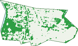
Green: 10 m cells where trees dominate, satellite 2021. Blue: water. The line is the suburb boundary.
| Canopy share, 1 m canopy height map, 2020 | 23.1% |
|---|---|
| Land with trees, 10 m satellite map, 2021 | 26.8% |
Demographics
Unemployment 4.1% · Labour-force participation 68.6%
Population by age in Sherwood
| 0-4 | 298 |
|---|---|
| 5-14 | 767 |
| 15-19 | 405 |
| 20-24 | 401 |
| 25-34 | 868 |
| 35-44 | 862 |
| 45-54 | 869 |
| 55-64 | 651 |
| 65-74 | 558 |
| 75-84 | 315 |
| 85+ | 98 |
Dwelling types in Sherwood
| House | 1,292 |
|---|---|
| Townhouse | 404 |
| Apartment | 799 |
| Other | 8 |
Households by weekly income in Sherwood
| <$650 | 355 |
|---|---|
| $650-1,499 | 540 |
| $1,500-2,999 | 703 |
| $3,000+ | 801 |
Top ancestries in Sherwood
| English | 2,436 |
|---|---|
| Australian | 1,945 |
| Irish | 982 |
| Scottish | 869 |
| Other | 779 |
| German | 400 |
Housing tenure in Sherwood
| Owned | 713 |
|---|---|
| Mortgage | 818 |
| Rented | 914 |
| Other | 45 |
Cars per household in Sherwood
| 0 | 222 |
|---|---|
| 1 | 1,104 |
| 2 | 880 |
| 3 | 187 |
| 4+ | 99 |
Commute to work in Sherwood
| Car | 1,481 |
|---|---|
| Train | 232 |
| Bus | 15 |
| Tram/ferry | 0 |
| Walked | 70 |
| Bicycle | 45 |
| Home | 916 |
Top countries of birth in Sherwood
| England | 298 |
|---|---|
| New Zealand | 139 |
| India | 116 |
| China | 72 |
| United States | 67 |
| South Africa | 61 |
Languages used at home in Sherwood
| Mandarin | 93 |
|---|---|
| Japanese | 72 |
| Vietnamese | 50 |
| Spanish | 47 |
| Korean | 42 |
| Hindi | 38 |
Birds & Wildlife Nearby
432,186 bird observations recorded near Sherwood — most often seen:
- Noisy Miner (26,011)
- Torresian Crow (24,690)
- Rainbow Lorikeet (22,113)
- Australian Magpie (19,486)
- Australian White Ibis (19,044)
- Welcome Swallow (19,022)
- Grey Butcherbird (16,838)
- Magpie-lark (15,875)
- Willie Wagtail (15,550)
- Pacific Black Duck (14,700)
- Pied Butcherbird (14,501)
- Australasian Figbird (14,223)
- Pied Currawong (13,665)
Show all 30 birds recorded near Sherwood
- Dusky Moorhen (13,498)
- Laughing Kookaburra (13,146)
- Australasian Purple Swamphen (13,095)
- Brown Honeyeater (13,077)
- Masked Lapwing (13,007)
- Scaly-breasted Lorikeet (12,848)
- Australian Brush-turkey (12,358)
- Blue-faced Honeyeater (12,215)
- Sulphur-crested Cockatoo (12,010)
- Crested Pigeon (11,386)
- Australian Wood Duck (10,866)
- Lewin's Honeyeater (10,174)
- Red-backed Fairy-wren (10,024)
- Little Black Cormorant (9,870)
- Black-faced Cuckoo-shrike (9,840)
- Spotted Turtle-dove (9,803)
- Australasian Darter (9,251)
Sightings reported by observers, not a survey, so the counts show what people record rather than what lives here. Source: Atlas of Living Australia.
Nearby Suburbs
The closest suburbs to Sherwood:
- Graceville (1.1 km)
- Corinda (1.3 km)
- Fig Tree Pocket (2.1 km)
- Chelmer (2.1 km)
- Tennyson (2.4 km)
- Seventeen Mile Rocks (3.1 km)
- Oxley (3.3 km)
- Sinnamon Park (3.4 km)
Embed this suburb
Add this free Sherwood stat card to your own site — just copy the code:
Preview:
Cite this page
Quoting these figures? Copy the credit line:
Keep an eye on Sherwood
One email when this data meaningfully changes — new census figures, prices, rankings. No spam, unsubscribe anytime.
Streets
- Arbour Street (27)
- Augustus Street (2)
- Barchester Street (30)
- Bentinck Street (37)
- Berry Street (77)
- Blackwood Street (19)
- Borden Street (96)
- Bute Street (77)
- Central Avenue (137)
- Chancellor Street (72)
- Cormack Street (23)
- Coyne Street (36)
- Dewar Terrace (84)
- Douglas Street (39)
- Dudley Street (45)
- Dunella Street (29)
- Egmont Street (133)
- Elizabeth Street (34)
- Ettie Street (18)
- Ferry Street (20)
- Galloway Street (8)
- Hall Street (31)
- Hamilton Street (45)
- Hazelmere Parade (40)
- Hedges Street (18)
- Hilda Street (4)
- Honour Avenue (40)
- Hood Street (249)
- Jerrold Street (111)
- Johnstone Street (10)
- Jolimont Street (35)
- Jordan Street (14)
- Joseph Street (7)
- Junction Street (28)
- Kenilworth Street (17)
- Kinkead Avenue (11)
- Kitchener Street (32)
- Lahey Close (26)
- Lance Street (43)
- Lilly Street (44)
- Linda Street (18)
- Lockwood Street (26)
- Long Street E (3)
- Long Street W (3)
- Magazine Street (40)
- Marlborough Street (26)
- Mayhew Street (188)
- Mcculla Street (17)
- Mcdougall Street (4)
- Oman Street (1)
- Oxley Road (387)
- Palm Avenue (19)
- Park Terrace (59)
- Plumer Street (101)
- Primrose Street (351)
- Prospect Street (32)
- Quarry Road (151)
- Railway Terrace (11)
- Robertson Street (48)
- Sherwood Road (384)
- Skew Street (169)
- Strickland Terrace (45)
- Tainton Street (2)
- Thallon Street (50)
- Thomas Street (50)
- Turner Street (22)
- Weinholt Street (34)
- Woodberry Avenue (12)