Rangemore QLD 4806
2 addresses · 1 street
Dawson Electorate › Burdekin LGA › Rangemore · 1005 km from Brisbane

Getting Around & Local Services
Loading nearby places…
Tree cover
🌳 Tree canopy: 17.9% share of land under canopy · satellite map, 2020
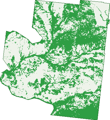
Green: 10 m cells where trees dominate, satellite 2021. Blue: water. The line is the suburb boundary.
| Canopy share, 1 m canopy height map, 2020 | 17.9% |
|---|---|
| Land with trees, 10 m satellite map, 2021 | 45.8% |
Birds & Wildlife Nearby
1 bird observations recorded near Rangemore — most often seen:
Sightings reported by observers, not a survey, so the counts show what people record rather than what lives here. Source: Atlas of Living Australia.
Nearby Suburbs
The closest suburbs to Rangemore:
- Millaroo (16.5 km)
- Swans Lagoon (18.3 km)
- Dalbeg (28.8 km)
- Wangaratta (28.8 km)
- Kirknie (29.7 km)
- Mulgrave (30.2 km)
- Gumlu (30.6 km)
- Clare (32.2 km)
Embed this suburb
Add this free Rangemore stat card to your own site — just copy the code:
Preview:
Cite this page
Quoting these figures? Copy the credit line:
Keep an eye on Rangemore
One email when this data meaningfully changes — new census figures, prices, rankings. No spam, unsubscribe anytime.
Streets
- Rangemore Road (2)