Park Ridge QLD 4125
9,225 addresses · 246 streets
Forde Electorate › Logan LGA › Park Ridge · 27 km from Brisbane
📦 Thinking of moving here? Read the Park Ridge moving guide

Living Here
A fast-growing semi-rural suburb in the Logan area south of Brisbane, Park Ridge is transitioning to new family estates. A young median age of 30 and households of 2.6 people prevail; combined household income is $1,418 a week, with rent around $370.
Park Ridge is a suburb of Queensland, home to about 8,455 people, with a median age of 30. The typical household earns around $1,418 a week, with median rent near $370 a week. Most homes are houses. About 47% of households own their home and 51% rent. Most workers drive to work. Common community backgrounds include English, Australian, Ancestry NS. On the ABS socio-economic scale it sits in decile 3 of 10 nationally — a more disadvantaged area.
Over time — Census 2001 → 2021
Dashed line: district figures for the Boronia Heights - Park Ridge statistical area (SA2), the smallest area the ABS published before 2011. Solid line: Park Ridge itself.
Getting Around & Local Services
1 café or restaurant
2 supermarkets
1 dentist
1 childcare centre
2 libraries
4 gyms & sports centres
2 golf clubs
3 hardware stores
1 mechanic
1 electrician
3 plumbers
1 place to stay
Getting around. Train station: Kingston, 7.1 km north-east · Bus interchange: Clarks Logan City Bus Service - Bus Depot, 6.9 km north-east · Airport: Brisbane Airport, 36.6 km north.
Socio-economic Standing
Deciles from 1 (lowest) to 10 (highest), against all Australian suburbs. The overall figure weighs advantage and disadvantage together; economic resources counts income and housing, and education & jobs counts qualifications and occupation. They often differ. Source: ABS SEIFA 2021.
Tree cover
🌳 Tree canopy: 41.4% share of land under canopy · satellite map, 2020
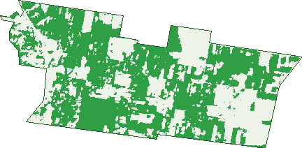
Green: 10 m cells where trees dominate, satellite 2021. Blue: water. The line is the suburb boundary.
| Canopy share, 1 m canopy height map, 2020 | 41.4% |
|---|---|
| Land with trees, 10 m satellite map, 2021 | 58.4% |
Demographics
Unemployment 6.6% · Labour-force participation 60.2%
Population by age in Park Ridge
| 0-4 | 835 |
|---|---|
| 5-14 | 1,032 |
| 15-19 | 398 |
| 20-24 | 864 |
| 25-34 | 1,938 |
| 35-44 | 938 |
| 45-54 | 651 |
| 55-64 | 510 |
| 65-74 | 654 |
| 75-84 | 503 |
| 85+ | 129 |
Dwelling types in Park Ridge
| House | 2,444 |
|---|---|
| Townhouse | 494 |
| Apartment | 0 |
| Other | 32 |
Households by weekly income in Park Ridge
| <$650 | 436 |
|---|---|
| $650-1,499 | 1,044 |
| $1,500-2,999 | 988 |
| $3,000+ | 304 |
Top ancestries in Park Ridge
| English | 2,698 |
|---|---|
| Australian | 2,113 |
| Other | 1,749 |
| Ancestry NS | 776 |
| Scottish | 534 |
| Irish | 519 |
Housing tenure in Park Ridge
| Owned | 718 |
|---|---|
| Mortgage | 657 |
| Rented | 1,497 |
| Other | 44 |
Cars per household in Park Ridge
| 0 | 135 |
|---|---|
| 1 | 1,144 |
| 2 | 1,145 |
| 3 | 304 |
| 4+ | 182 |
Commute to work in Park Ridge
| Car | 2,837 |
|---|---|
| Train | 12 |
| Bus | 34 |
| Tram/ferry | 0 |
| Walked | 26 |
| Bicycle | 0 |
| Home | 276 |
Top countries of birth in Park Ridge
| New Zealand | 809 |
|---|---|
| India | 485 |
| England | 270 |
| Philippines | 133 |
| Samoa | 101 |
| Fiji | 80 |
Languages used at home in Park Ridge
| Punjabi | 472 |
|---|---|
| Samoan | 205 |
| Mandarin | 169 |
| Hindi | 113 |
| Urdu | 71 |
| Tagalog | 69 |
Birds & Wildlife Nearby
23,255 bird observations recorded near Park Ridge — most often seen:
- Torresian Crow (1,279)
- Rainbow Lorikeet (1,089)
- Australian White Ibis (1,024)
- Noisy Miner (989)
- Australian Magpie (961)
- Pacific Black Duck (905)
- Australasian Darter (853)
- Brown Honeyeater (843)
- Magpie-lark (835)
- Noisy Friarbird (829)
- Laughing Kookaburra (827)
- Dusky Moorhen (809)
- Striated Pardalote (780)
Show all 30 birds recorded near Park Ridge
- Australian Pelican (776)
- Little Black Cormorant (731)
- Australasian Purple Swamphen (729)
- Pied Butcherbird (723)
- Grey Butcherbird (709)
- Willie Wagtail (703)
- Bar-shouldered Dove (688)
- Black-faced Cuckoo-shrike (676)
- Yellow-faced Honeyeater (668)
- Sulphur-crested Cockatoo (664)
- Australian Wood Duck (620)
- Variegated Fairy-wren (614)
- Little Pied Cormorant (599)
- Blue-faced Honeyeater (595)
- Spotted Turtle-dove (587)
- Grey Shrike-thrush (578)
- Superb Fairy-wren (572)
Sightings reported by observers, not a survey, so the counts show what people record rather than what lives here. Source: Atlas of Living Australia.
Nearby Suburbs
The closest suburbs to Park Ridge:
- Crestmead (2.5 km)
- Heritage Park (2.9 km)
- Chambers Flat (3.2 km)
- Logan Reserve (3.6 km)
- Park Ridge South (4.1 km)
- Marsden (4.2 km)
- Regents Park (4.4 km)
- Berrinba (5.2 km)
Embed this suburb
Add this free Park Ridge stat card to your own site — just copy the code:
Preview:
Cite this page
Quoting these figures? Copy the credit line:
Keep an eye on Park Ridge
One email when this data meaningfully changes — new census figures, prices, rankings. No spam, unsubscribe anytime.
Streets
- Airfield Street (24)
- Alexis Place (45)
- Allerton Park Drive (36)
- Angus Court (33)
- Anne Street (96)
- Arton Street (20)
- Austin Way (96)
- Ayman Road (6)
- Baileys Lane (14)
- Barbossa Street (6)
- Bark Street (35)
- Barley Street (22)
- Barnyard Drive (64)
- Basswood Circuit (40)
- Bayliss Road (2)
- Beaumont Road (8)
- Beck Road (10)
- Beck Street (142)
- Beech Street (14)
- Bellbird Place (8)
- Belvedere Drive (38)
- Billabong Drive (32)
- Birchwood Street (55)
- Black Cherry Street (22)
- Bloomfield Avenue (71)
- Bluebird Drive (13)
- Bluegum Drive (29)
- Bottlebrush Drive (5)
- Brooklyn Close (56)
- Brunner Drive (18)
- Bumstead Road (30)
- Bunya Drive (66)
- Burnley Road (22)
- Cadell Close (9)
- Carrington Circuit (45)
- Carvers Way (34)
- Ceratonia Street (1)
- Chambers Flat Road (33)
- Chambers Ridge Boulevard (78)
- Chatham Court (23)
- Chippendale Road (3)
- Clarke Road (108)
- Cockatoo Crescent (9)
- Colonial Way (50)
- Compal Road (4)
- Cottee Circuit (47)
- Country Court (11)
- Creaghe Street (13)
- Creek Place (102)
- Crest Road (11)
- Cycad Street (15)
- Cypress Street (18)
- Daintree Court (74)
- Darling Court (21)
- Davidson Circuit (75)
- Doran Circuit (62)
- Dorchester Drive (32)
- Eadie Road (6)
- Eadie Street (5)
- Ealham Lane (13)
- East Beaumont Road (127)
- Elite Street (15)
- Elkhorn Lane (2)
- Elon Street (8)
- Embleton Road (6)
- Endeavour Court (5)
- Eucalypt Drive (23)
- Exalt Place (8)
- Executive Drive (38)
- Falcon Road (23)
- Fariha Way (24)
- Farmer Place (100)
- Ferris Avenue (89)
- Fiddlewood Court (17)
- Fiveways Circuit (7)
- Flannery Terrace (37)
- Flint Place (40)
- Formosa Street (17)
- Foxtail Drive (32)
- Franklin Avenue (22)
- Frederick Place (51)
- Garrick Street (15)
- Gem Circuit (70)
- Ghostgum Court (9)
- Golden Gate Avenue (68)
- Goodwin Close (29)
- Granite Drive (4)
- Green Road (53)
- Greenridge Road (23)
- Grevillea Way (48)
- Hana Street (10)
- Harper Drive (5)
- Hartnell Drive (35)
- Hastings Street (34)
- Hawk Street (6)
- Haystack Close (21)
- Heath Terrace (29)
- Henchar Place (12)
- Heritage Way (49)
- Heron Place (4)
- Hewing Place (43)
- Hillcrest Road (9)
- Hinkler Way (4)
- Honey Eater Street (1)
- Hubner Road (55)
- Ibis Crescent (7)
- Idyllic Street (12)
- Indigo Lane (3)
- Innovation Way (3)
- Irma Circuit (47)
- Ironbark Avenue (22)
- Isla Street (65)
- Jabiry Place (7)
- Jacaranda Drive (9)
- Jackey Street (2)
- Jedfire Street (10)
- Joan Street (10)
- John Storey Court (55)
- Junction Road (4)
- Kantenna Street (15)
- Kestrel Road (80)
- Kingfisher Drive (31)
- Kookaburra Drive (28)
- Kookaburra Way (11)
- Koplick Road (28)
- Lakeside Drive (5)
- Lamington Drive (1)
- Lancewood Street (11)
- Lani Street (16)
- Leichhardt Close (1)
- Lilac Street (2)
- Lindenthal Road (25)
- Livadi Street (18)
- Lorikeet Street (15)
- Lyrebird Drive (57)
- Lyrebird Street (1)
- Macadamia Circuit (81)
- Malop Street (2)
- Mango Road (22)
- Mapletree Drive (4)
- Marcus Street (8)
- Mcleod Road (16)
- Mercantile Drive (12)
- Mercy Circuit (175)
- Merino Street (66)
- Merrystowe Circuit (25)
- Mexicanus Drive (20)
- Moorabool Street (16)
- Mount Archer Road (16)
- Mount Ballow Street (15)
- Mount Barney Crescent (48)
- Mount Bowen Street (31)
- Mount Cooroora Street (26)
- Mount Crosby Street (36)
- Mount Edwards Street (37)
- Mount Emerald Street (25)
- Mount French Street (4)
- Mount Glorious Street (69)
- Mount Greville Way (29)
- Mount Huntley Street (108)
- Mount Lindesay Highway (687)
- Mount Mee Street (42)
- Mount Mitchell Road (27)
- Mount Mitchell Street (127)
- Mount Nebo Street (5)
- Mount Petrie Lane (4)
- Mount Pleasant Street (41)
- Mount Roberts Street (23)
- Mount Wheeler Street (54)
- Mt Archer Road (6)
- Mt Barney Crescent (14)
- Mt Greville Way (6)
- Mt Mee Street (15)
- Nevada Avenue (75)
- Nevada Road (81)
- Niels Crescent (88)
- Norfolk Lane (6)
- Notley Lane (14)
- Nura Drive (4)
- Nursery Street (2)
- Olaf Loop (41)
- Olympia Road (7)
- Osprey Place (8)
- Paige Street (7)
- Parakeet Place (10)
- Park Ridge Road (1,030)
- Peacock Street (7)
- Pearl Street (3)
- Pee Wee Street (6)
- Peregrine Street (11)
- Pheasant Drive (8)
- Plover Crescent (9)
- Prioress Place (17)
- Prospect Place (24)
- Prosperity Place (25)
- Quantam Court (6)
- Raven Court (40)
- Redcomb Drive (73)
- Relentless Court (8)
- Rosella Court (4)
- Rosella Place (7)
- Rosia Road (38)
- Royal Street (90)
- Ruby Street (6)
- Rural Street (119)
- Ryrie Court (124)
- Sago Road (30)
- Salmar Street (19)
- Sapphire Street (26)
- Satinash Street (18)
- Selwyn Avenue (5)
- Shalloak Street (25)
- Sheepdog Road (53)
- Sienna Street (7)
- Sigma Road (2)
- Silkwood Circuit (61)
- Skelbrook Road (34)
- Somerville Circuit (52)
- Sovereign Street (12)
- Spencer Way (7)
- Spoonbill Place (8)
- Stockman Way (23)
- Stockyard Lane (22)
- Sugar Maple Place (46)
- Swagman Way (13)
- Talinga Drive (254)
- Tamarind Crescent (34)
- The Beaten Track (8)
- Tillerman Parade (10)
- Tulip Tree Street (58)
- Vinnicombe Circuit (33)
- Wagtail Street (7)
- Walker Street (46)
- Wallaby Court (15)
- Waller Road (51)
- Wang Street (9)
- Watertower Street (21)
- Wattlebrush Court (24)
- Weedbrook Street (81)
- White Ash Way (4)
- Wicker Road (67)
- William Close (20)
- Woodend Court (24)
- Worsley Lane (3)
- Yorkshire Road (6)
- Zaffar Avenue (39)