Paradise Point QLD 4216
4,869 addresses · 92 streets
Fadden Electorate › Gold Coast LGA › Paradise Point · 58 km from Brisbane
📦 Thinking of moving here? Read the Paradise Point moving guide

Living Here
Paradise Point is a suburb of Queensland, home to about 7,062 people, with a median age of 53. The typical household earns around $1,688 a week, with median rent near $450 a week. Most homes are houses. About 73% of households own their home and 26% rent. Most workers drive to work. Common community backgrounds include English, Australian, Irish. On the ABS socio-economic scale it sits in decile 9 of 10 nationally — a relatively advantaged area.
Over time — Census 2001 → 2021
Dashed line: district figures for the Paradise Point - Hollywell statistical area (SA2), the smallest area the ABS published before 2011. Solid line: Paradise Point itself.
Getting Around & Local Services
1 Catholic church
1 medical clinic
1 optometrist
2 childcare & kindergartens
1 library
1 post office
3 gyms & sports centres
2 playgrounds
1 bakery
1 mechanic
1 plumber
Getting around. Train station: Hope Island, 6.3 km west · Railway halt: Wildlife, 7.9 km west · Bus interchange: Soutport Transit Centre, 9.3 km south · Ferry wharf: Runnaway Bay, 3.7 km south · Airport: Southport Flying Club, 5.1 km south-west.
Socio-economic Standing
Deciles from 1 (lowest) to 10 (highest), against all Australian suburbs. The overall figure weighs advantage and disadvantage together; economic resources counts income and housing, and education & jobs counts qualifications and occupation. They often differ. Source: ABS SEIFA 2021.
Tree cover
🌳 Tree canopy: 11% share of land under canopy · satellite map, 2020
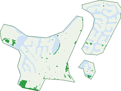
Green: 10 m cells where trees dominate, satellite 2021. Blue: water. The line is the suburb boundary.
| Canopy share, 1 m canopy height map, 2020 | 11.0% |
|---|---|
| Land with trees, 10 m satellite map, 2021 | 3.7% |
Demographics
Unemployment 3.5% · Labour-force participation 52.5%
Population by age in Paradise Point
| 0-4 | 258 |
|---|---|
| 5-14 | 580 |
| 15-19 | 337 |
| 20-24 | 300 |
| 25-34 | 488 |
| 35-44 | 649 |
| 45-54 | 1,076 |
| 55-64 | 1,247 |
| 65-74 | 1,255 |
| 75-84 | 698 |
| 85+ | 174 |
Dwelling types in Paradise Point
| House | 1,486 |
|---|---|
| Townhouse | 958 |
| Apartment | 425 |
| Other | 0 |
Households by weekly income in Paradise Point
| <$650 | 500 |
|---|---|
| $650-1,499 | 761 |
| $1,500-2,999 | 686 |
| $3,000+ | 737 |
Top ancestries in Paradise Point
| English | 3,026 |
|---|---|
| Australian | 2,062 |
| Irish | 747 |
| Scottish | 734 |
| Other | 598 |
| Ancestry NS | 582 |
Housing tenure in Paradise Point
| Owned | 1,243 |
|---|---|
| Mortgage | 830 |
| Rented | 733 |
| Other | 36 |
Cars per household in Paradise Point
| 0 | 107 |
|---|---|
| 1 | 1,012 |
| 2 | 1,167 |
| 3 | 363 |
| 4+ | 194 |
Commute to work in Paradise Point
| Car | 2,081 |
|---|---|
| Train | 16 |
| Bus | 7 |
| Tram/ferry | 0 |
| Walked | 33 |
| Bicycle | 16 |
| Home | 627 |
Top countries of birth in Paradise Point
| England | 472 |
|---|---|
| New Zealand | 461 |
| China | 118 |
| South Africa | 107 |
| Germany | 47 |
| Philippines | 45 |
Languages used at home in Paradise Point
| Mandarin | 141 |
|---|---|
| Cantonese | 39 |
| Spanish | 37 |
| Italian | 31 |
| German | 28 |
| Greek | 26 |
Birds & Wildlife Nearby
27,517 bird observations recorded near Paradise Point — most often seen:
- Australian White Ibis (1,539)
- Rainbow Lorikeet (1,511)
- Noisy Miner (1,505)
- Torresian Crow (1,496)
- Australian Magpie (1,361)
- Welcome Swallow (1,232)
- Magpie-lark (1,164)
- Pacific Black Duck (1,085)
- Pied Butcherbird (989)
- Australian Pelican (972)
- Masked Lapwing (963)
- Pied Currawong (960)
- Australian Wood Duck (935)
Show all 30 birds recorded near Paradise Point
- Willie Wagtail (895)
- Laughing Kookaburra (800)
- White-faced Heron (762)
- Whistling Kite (756)
- Noisy Friarbird (728)
- Chestnut Teal (724)
- Silver Gull (717)
- Brown Honeyeater (693)
- Grey Butcherbird (693)
- Little Black Cormorant (670)
- Crested Pigeon (664)
- Royal Spoonbill (658)
- Grey Fantail (641)
- Black-faced Cuckoo-shrike (622)
- Scaly-breasted Lorikeet (617)
- Grey Shrike-thrush (597)
- Dusky Moorhen (568)
Sightings reported by observers, not a survey, so the counts show what people record rather than what lives here. Source: Atlas of Living Australia.
Nearby Suburbs
The closest suburbs to Paradise Point:
- Hollywell (1.6 km)
- Coombabah (3 km)
- Hope Island (3.6 km)
- Runaway Bay (4.1 km)
- Biggera Waters (5.5 km)
- Helensvale (6.4 km)
- South Stradbroke (6.4 km)
- Coomera (6.8 km)
Embed this suburb
Add this free Paradise Point stat card to your own site — just copy the code:
Preview:
Cite this page
Quoting these figures? Copy the credit line:
Keep an eye on Paradise Point
One email when this data meaningfully changes — new census figures, prices, rankings. No spam, unsubscribe anytime.
Streets
- Abalone Avenue (115)
- Arrowsmith Court (7)
- Bass Place (18)
- Bayview Street (13)
- Beardsley Court (16)
- Belair Crescent (12)
- Blaxland Avenue (14)
- Brittanic Crescent (52)
- Broadwater Precinct (53)
- Bruce Avenue (125)
- Dobell Avenue (24)
- Donald Avenue (75)
- Drake Avenue (88)
- Drysdale Place (27)
- Eider Avenue (69)
- Ephraim Island (4)
- Ephraim Island Marina Parade (2)
- Ephraim Island Parade (381)
- Errol Avenue (159)
- Esplanade W (25)
- Esplanade West (30)
- Esplanade West (26)
- Eurimbula Court (66)
- Excalibur Court (28)
- Eyre Street (7)
- Falkinder Avenue (138)
- Flinders Court (6)
- Grice Avenue (72)
- Hampton Court (37)
- Havana Way (23)
- Hume Parade (39)
- Inlet Precinct (70)
- Joy Avenue (12)
- Kensington Mews (14)
- Killowill Avenue (32)
- King Arthurs Court (46)
- King Charles Drive (57)
- King James Court (22)
- Knightsbridge Parade E (67)
- Knightsbridge Parade W (54)
- Lakefield Crescent (47)
- Lindsay Parade (56)
- Maiala Close (78)
- Mallard Avenue (70)
- Marina Promenade (190)
- Matthew Flinders Drive (10)
- Milton Avenue (166)
- Moira Court (4)
- Muscovey Avenue (67)
- Namatjira Street (10)
- Nankeen Avenue (100)
- O'grady Drive (67)
- Oceania Way (13)
- Oxley Drive (163)
- Paradise Parade (176)
- Parklane Terrace (28)
- Paterson Place (23)
- Plover Avenue (20)
- Promontory Precinct (13)
- Queen Anne Court (21)
- Queen Guineveres Place (24)
- Regents Court (27)
- Reserve Precinct (9)
- River Vista Way (24)
- Robin Avenue (17)
- Rosalind Avenue (24)
- Rouen Avenue (58)
- Royal Albert Crescent (77)
- Royal Mews (6)
- Salacia Drive (10)
- Scoter Avenue (62)
- Seabreeze Street (28)
- Seaspray Street (52)
- Shoveller Avenue (60)
- Shute Court (6)
- Sir Galahad Close (8)
- Sir Lancelot Close (3)
- Sunbird Avenue (33)
- Sundown Drive (41)
- Sunset Avenue (36)
- Swallow Avenue (22)
- Teal Avenue (69)
- The Esplanade (212)
- The Peninsula (53)
- The Sovereign Mile (95)
- Thrush Avenue (41)
- Tradewinds Avenue (99)
- Victor Avenue (126)
- Warrie Close (42)
- Westminster Court (17)
- Wills Court (8)
- Woodgate Place (33)