Maryborough QLD 4650
9,298 addresses · 211 streets
Wide Bay Electorate › Fraser Coast LGA › Maryborough · 218 km from Brisbane
📦 Thinking of moving here? Read the Maryborough moving guide

Living Here
A historic regional city on the Fraser Coast of Queensland, Maryborough has a heritage character and an older profile (median age 49). Households average 2.2 people. Median household income is $926 a week, and rent is very affordable at around $250.
Maryborough is a suburb of Queensland, home to about 15,287 people, with a median age of 49. The typical household earns around $926 a week, with median rent near $250 a week. Most homes are houses. About 63% of households own their home and 35% rent. Most workers drive to work. Common community backgrounds include English, Australian, Scottish. On the ABS socio-economic scale it sits in decile 1 of 10 nationally — a more disadvantaged area.
Over time — Census 2001 → 2021
Dashed line: district figures for the Maryborough (Qld) statistical area (SA2), the smallest area the ABS published before 2011. Solid line: Maryborough itself.
Getting Around & Local Services
1 Catholic church
1 dentist
1 physiotherapist
3 optometrists
2 childcare & kindergartens
1 library
2 post offices
1 golf club
2 hardware stores
2 electricians
Getting around. Train station: Maryborough, 1 km south · Airport: Maryborough Airport, 2.3 km north-east.
Socio-economic Standing
Deciles from 1 (lowest) to 10 (highest), against all Australian suburbs. The overall figure weighs advantage and disadvantage together; economic resources counts income and housing, and education & jobs counts qualifications and occupation. They often differ. Source: ABS SEIFA 2021.
Tree cover
🌳 Tree canopy: 32.5% share of land under canopy · satellite map, 2020
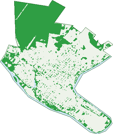
Green: 10 m cells where trees dominate, satellite 2021. Blue: water. The line is the suburb boundary.
| Canopy share, 1 m canopy height map, 2020 | 32.5% |
|---|---|
| Land with trees, 10 m satellite map, 2021 | 36.4% |
Demographics
Unemployment 12.2% · Labour-force participation 42.6%
Population by age in Maryborough
| 0-4 | 627 |
|---|---|
| 5-14 | 1,733 |
| 15-19 | 915 |
| 20-24 | 796 |
| 25-34 | 1,388 |
| 35-44 | 1,484 |
| 45-54 | 1,801 |
| 55-64 | 2,195 |
| 65-74 | 2,273 |
| 75-84 | 1,438 |
| 85+ | 631 |
Dwelling types in Maryborough
| House | 5,426 |
|---|---|
| Townhouse | 558 |
| Apartment | 362 |
| Other | 40 |
Households by weekly income in Maryborough
| <$650 | 1,853 |
|---|---|
| $650-1,499 | 2,424 |
| $1,500-2,999 | 1,255 |
| $3,000+ | 355 |
Top ancestries in Maryborough
| English | 6,790 |
|---|---|
| Australian | 6,455 |
| Scottish | 1,676 |
| Irish | 1,675 |
| German | 1,327 |
| Ancestry NS | 1,033 |
Housing tenure in Maryborough
| Owned | 2,414 |
|---|---|
| Mortgage | 1,521 |
| Rented | 2,161 |
| Other | 125 |
Cars per household in Maryborough
| 0 | 748 |
|---|---|
| 1 | 2,744 |
| 2 | 1,828 |
| 3 | 579 |
| 4+ | 315 |
Commute to work in Maryborough
| Car | 3,543 |
|---|---|
| Train | 4 |
| Bus | 16 |
| Tram/ferry | 0 |
| Walked | 228 |
| Bicycle | 77 |
| Home | 232 |
Top countries of birth in Maryborough
| England | 397 |
|---|---|
| New Zealand | 259 |
| Philippines | 123 |
| Germany | 68 |
| Scotland | 65 |
| India | 38 |
Languages used at home in Maryborough
| Tagalog | 33 |
|---|---|
| Filipino | 30 |
| German | 28 |
| Thai | 23 |
| Punjabi | 16 |
| Italian | 16 |
Birds & Wildlife Nearby
9,612 bird observations recorded near Maryborough — most often seen:
- Australian White Ibis (605)
- Pacific Black Duck (545)
- Rainbow Lorikeet (496)
- Magpie-lark (479)
- Noisy Miner (447)
- Torresian Crow (444)
- Australian Magpie (375)
- Crested Pigeon (364)
- Willie Wagtail (352)
- Australasian Figbird (351)
- Dusky Moorhen (349)
- Brown Honeyeater (331)
- Blue-faced Honeyeater (312)
Show all 30 birds recorded near Maryborough
- Australasian Purple Swamphen (291)
- Little Black Cormorant (284)
- Black-faced Cuckoo-shrike (265)
- Eastern Rainbow Lorikeet (265)
- Spotted Turtle-dove (263)
- Little Corella (255)
- Australian Wood Duck (254)
- Little Pied Cormorant (248)
- Southern Magpie-lark (238)
- Laughing Kookaburra (235)
- Masked Lapwing (232)
- Double-barred Finch (230)
- Welcome Swallow (230)
- Australian Pelican (225)
- Hardhead (219)
- Eastern Australian Magpie (216)
- Little Friarbird (212)
Sightings reported by observers, not a survey, so the counts show what people record rather than what lives here. Source: Atlas of Living Australia.
Nearby Suburbs
The closest suburbs to Maryborough:
- Granville (2.8 km)
- Tinana (3.7 km)
- Island Plantation (4 km)
- Maryborough West (4.3 km)
- St Helens (4.7 km)
- Walkers Point (5.4 km)
- Bidwill (7 km)
- Oakhurst (7.1 km)
Embed this suburb
Add this free Maryborough stat card to your own site — just copy the code:
Preview:
Cite this page
Quoting these figures? Copy the credit line:
Keep an eye on Maryborough
One email when this data meaningfully changes — new census figures, prices, rankings. No spam, unsubscribe anytime.
Streets
- Aberdeen Avenue (68)
- Adelaide Lane (29)
- Adelaide Street (153)
- Ajax Street (10)
- Alan Street (3)
- Albert Place (6)
- Albert Street (170)
- Aldridge Street (36)
- Alfred Street (3)
- Alice Street (345)
- Alvie Street (26)
- Ambrose White Street (19)
- Amity Street (36)
- Ann Street (200)
- Anthony Court (10)
- Anzac Street (5)
- Arbury Street (25)
- Ariadne Street (115)
- Arthur Street (17)
- Ashton Street (7)
- Avon Street (6)
- Bashford Street (13)
- Bazaar Street (209)
- Bedford Street (18)
- Belinda Close (12)
- Bell Street (19)
- Bluegum Court (32)
- Bongoola Road (2)
- Booker Street (2)
- Bowen Street (3)
- Box Street (14)
- Boys Avenue (59)
- Brennan Avenue (12)
- Bright Street (1)
- Bryant Street (30)
- Buckler Street (13)
- Burrum Street (32)
- Campbell Street (50)
- Caringa Street (15)
- Carlisle Street (22)
- Carlson Avenue (12)
- Carnarvon Street (6)
- Charlemont Street (16)
- Charles Street (8)
- Cheapside Street (210)
- Christensen Crescent (37)
- Churchill Street (178)
- Clarke Place (2)
- Clayton Street (17)
- Cobden Street (3)
- Comet Street (2)
- Connolly Street (29)
- Corser Avenue (8)
- Coventry Street (22)
- Crimmens Street (15)
- Crown Street (37)
- Croydon Street (22)
- Cunningham Street (13)
- Cutlers Lane (6)
- Dalglish Street (28)
- Dalhousie Street (11)
- Degilbo Street (32)
- Demaine Street (8)
- Diana Street (14)
- Doon Villa Avenue (21)
- Dowzer Street (2)
- Draeger Street (13)
- Dry Street (3)
- Dunn Street (26)
- Dymock Street (31)
- Edward Street (65)
- Elizabeth Street (14)
- Ella Street (40)
- Ellena Street (180)
- Ellis Street (15)
- Errol Street (48)
- Eucalypt Drive (17)
- Eva Street (15)
- Fairlie Avenue (4)
- Farrell Street (19)
- Ferry Lane (101)
- Ferry Lane S (1)
- Ferry Street (163)
- Fort Lane (55)
- Fort Street (140)
- Frank Street (77)
- French Avenue (8)
- Gallipoli Street (57)
- Garden Street (48)
- Gayndah Road (8)
- Gayndah Road E (8)
- Gaynor Street (20)
- George Street (79)
- Gilbert Street (8)
- Gillhespy Street (35)
- Glasgow Street (5)
- Goldsmith Street (2)
- Greenway Court (31)
- Gregory Court (7)
- Grosvenor Street (34)
- Guava Street (22)
- Hart Street (11)
- Harwood Street (6)
- Hawthorne Street (6)
- Holbut Street (3)
- Howard Street (13)
- Hunter Street (21)
- Hyne Street (27)
- Iris Street (2)
- James Street (50)
- Jaye Court (11)
- John Lane (55)
- John Street (242)
- Jupiter Street (100)
- Katherine Street (13)
- Keith Street (14)
- Kenilworth Street (7)
- Kent Street (428)
- Kidd Avenue (20)
- King Street (30)
- Lambert Street (16)
- Lennox Street (331)
- Macadam Street (15)
- Magnolia Court (10)
- March Lane (21)
- March Street (101)
- Margaret Street (15)
- Mary Street (39)
- Matthies Street (4)
- Mccarroll Court (1)
- Mccarroll Street (1)
- Mcghie Avenue (16)
- Melville Street (66)
- Meredith Street (18)
- Milton Street (84)
- Moreton Street (24)
- Morning Street (34)
- Mouquet Lane (11)
- Muriel Street (39)
- Neptune Street (131)
- New Street (9)
- Norman Parade (9)
- Normanby Street (6)
- North Street (161)
- Norway Street (12)
- Nuneaton Street (13)
- Pallas Street (349)
- Palmer Street (9)
- Panorama Drive (39)
- Park Street (12)
- Parkview Court (6)
- Percy Street (20)
- Pioch Street (13)
- Pleasant Street (36)
- Premier Street (14)
- Price Street (7)
- Prospect Street (11)
- Queen Street (228)
- Queens Place (1)
- Racecourse Road (1)
- Raven Street (26)
- Reed Avenue (32)
- Rex Street (1)
- Richard Street (52)
- Richmond Lane (89)
- Richmond Street (110)
- Robinson Street (15)
- Rocky Street (93)
- Roseneath Street (38)
- Russell Street (44)
- Saint Clair Avenue (12)
- Saltwater Creek Road (136)
- Scott Street (14)
- Searle Street (18)
- Sheldon Drive (13)
- Shumack Drive (21)
- Smith Street (44)
- Sprake Drive (23)
- St Clair Avenue (1)
- Stafford Street (25)
- Stevenson Street (29)
- Sussex Street (144)
- Sydney Street (24)
- Tanner Street (8)
- Thomas Street (13)
- Thurecht Street (40)
- Tiger Street (10)
- Tooley Street (286)
- Treasure Street (44)
- Union Street (10)
- Unity Street (31)
- Victory Street (41)
- Vista Street (30)
- Walker Street (290)
- Walton Street (14)
- Waratah Street (3)
- Ward Street (58)
- Waterston Street (24)
- Wattle Court (6)
- Wharf Street (39)
- William Street (24)
- Wilson Street (60)
- Winston Noble Drive (3)
- Wood Street (2)
- Woodrow Street (13)
- Woodstock Street (124)
- Wyland Street (8)
- Wynne Parade (29)
- Yaralla Street (31)
- York Avenue (3)
- Zante Street (53)