Kuraby QLD 4112
3,193 addresses · 130 streets
Moreton Electorate › Brisbane LGA › Kuraby · 17 km from Brisbane
📦 Thinking of moving here? Read the Kuraby moving guide

Living Here
Kuraby is a suburb of Queensland, home to about 8,737 people, with a median age of 34. The typical household earns around $2,136 a week, with median rent near $400 a week. Most homes are houses. About 74% of households own their home and 25% rent. Most workers drive to work. Common community backgrounds include Chinese, English, Australian. On the ABS socio-economic scale it sits in decile 8 of 10 nationally — a relatively advantaged area.
Over time — Census 2001 → 2021
Dashed line: district figures for the Kuraby statistical area (SA2), the smallest area the ABS published before 2011. Solid line: Kuraby itself.
Getting Around & Local Services
5 supermarkets
3 physiotherapists
3 optometrists
10 childcare & kindergartens
- Bright Future Early Education Centre
- Kids Academy Early Learning Runcorn
- The Avenues Early Learning Centre
- Rochedale Central Childcare
- Kingbird Early Childhood Development Centre
- Hatchlings Early Learning Centre
- Sunkids Eight Mile Plains
- Eight Mile Plains Community Children's Centre
- Seedlings Early Learning Rochedale
- Guppys Early Learning Centre
2 playgrounds
2 bakeries
2 hairdressers
2 beauty salons
3 electricians
1 plumber
Getting around. Train station: Kuraby, 450 m west · Bus interchange: Eight Mile Plains, 3 km north · Airport: Brisbane Airport, 25.2 km north.
Socio-economic Standing
Deciles from 1 (lowest) to 10 (highest), against all Australian suburbs. The overall figure weighs advantage and disadvantage together; economic resources counts income and housing, and education & jobs counts qualifications and occupation. They often differ. Source: ABS SEIFA 2021.
Tree cover
🌳 Tree canopy: 32% share of land under canopy · satellite map, 2020
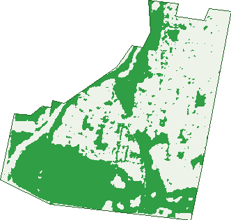
Green: 10 m cells where trees dominate, satellite 2021. Blue: water. The line is the suburb boundary.
| Canopy share, 1 m canopy height map, 2020 | 32.0% |
|---|---|
| Land with trees, 10 m satellite map, 2021 | 44.5% |
Demographics
Unemployment 6.3% · Labour-force participation 64%
Population by age in Kuraby
| 0-4 | 602 |
|---|---|
| 5-14 | 1,464 |
| 15-19 | 660 |
| 20-24 | 588 |
| 25-34 | 1,170 |
| 35-44 | 1,284 |
| 45-54 | 1,112 |
| 55-64 | 895 |
| 65-74 | 606 |
| 75-84 | 293 |
| 85+ | 67 |
Dwelling types in Kuraby
| House | 2,217 |
|---|---|
| Townhouse | 350 |
| Apartment | 3 |
| Other | 0 |
Households by weekly income in Kuraby
| <$650 | 248 |
|---|---|
| $650-1,499 | 563 |
| $1,500-2,999 | 866 |
| $3,000+ | 710 |
Top ancestries in Kuraby
| Other | 2,920 |
|---|---|
| Chinese | 1,426 |
| English | 1,314 |
| Australian | 1,267 |
| Indian | 1,070 |
| Ancestry NS | 381 |
Housing tenure in Kuraby
| Owned | 852 |
|---|---|
| Mortgage | 1,010 |
| Rented | 626 |
| Other | 23 |
Cars per household in Kuraby
| 0 | 44 |
|---|---|
| 1 | 666 |
| 2 | 1,193 |
| 3 | 412 |
| 4+ | 214 |
Commute to work in Kuraby
| Car | 2,552 |
|---|---|
| Train | 83 |
| Bus | 107 |
| Tram/ferry | 0 |
| Walked | 15 |
| Bicycle | 4 |
| Home | 670 |
Top countries of birth in Kuraby
| India | 545 |
|---|---|
| China | 458 |
| Pakistan | 411 |
| South Africa | 292 |
| New Zealand | 226 |
| Taiwan | 216 |
Languages used at home in Kuraby
| Mandarin | 861 |
|---|---|
| Urdu | 671 |
| Arabic | 432 |
| Cantonese | 380 |
| Punjabi | 329 |
| Korean | 233 |
Birds & Wildlife Nearby
31,130 bird observations recorded near Kuraby — most often seen:
- Rainbow Lorikeet (1,855)
- Noisy Miner (1,848)
- Torresian Crow (1,714)
- Laughing Kookaburra (1,654)
- Australian Magpie (1,571)
- Australian White Ibis (1,490)
- Dusky Moorhen (1,238)
- Australian Wood Duck (1,086)
- Pacific Black Duck (1,080)
- Australian Brush-turkey (992)
- Black-faced Cuckoo-shrike (926)
- Willie Wagtail (926)
- Crested Pigeon (922)
Show all 30 birds recorded near Kuraby
- Eastern Rainbow Lorikeet (917)
- Australian Torresian Crow (911)
- Magpie-lark (898)
- Pied Butcherbird (893)
- Tawny Frogmouth (884)
- Welcome Swallow (866)
- Southern Masked Lapwing (857)
- Grey Butcherbird (852)
- Scaly-breasted Lorikeet (849)
- Striated Pardalote (836)
- Coastal New South Wales Australian Magpie (818)
- Common Myna (780)
- Eastern Crested Pigeon (752)
- Brown Honeyeater (742)
- Pied Currawong (676)
- Silvereye (657)
- Australasian Figbird (640)
Sightings reported by observers, not a survey, so the counts show what people record rather than what lives here. Source: Atlas of Living Australia.
Nearby Suburbs
The closest suburbs to Kuraby:
- Underwood (1.5 km)
- Karawatha (1.9 km)
- Runcorn (2.1 km)
- Woodridge (2.8 km)
- Eight Mile Plains (2.9 km)
- Stretton (3.4 km)
- Rochedale South (3.4 km)
- Rochedale (4.1 km)
Embed this suburb
Add this free Kuraby stat card to your own site — just copy the code:
Preview:
Cite this page
Quoting these figures? Copy the credit line:
Keep an eye on Kuraby
One email when this data meaningfully changes — new census figures, prices, rankings. No spam, unsubscribe anytime.
Streets
- Aberdeen Crescent (44)
- Adventurer Street (12)
- Allbutt Street (76)
- Allingham Street (124)
- Alpita Street (83)
- Altoft Street (46)
- Annie Place (10)
- Balmoral Street (33)
- Barwon Court (5)
- Beenleigh Road (94)
- Bekker Place (9)
- Beris Crescent (40)
- Besline Street (74)
- Bhowani Place (12)
- Blackhorse Drive (12)
- Bogong Place (21)
- Bradford Place (38)
- Breezeway Court (7)
- Bush Pea Place (17)
- Canning Court (4)
- Caribbea Street (24)
- Carl Place (9)
- Cherie Court (6)
- Chesterfield Crescent (112)
- Christine Street (38)
- Clearview Close (9)
- Clifford Close (11)
- Colne Street (18)
- Compass Close (2)
- Compton Road (27)
- Coral Gum Court (7)
- Courtney Place (19)
- Crestwood Street (27)
- Crown Place (11)
- Davenport Place (21)
- Deborah Street (11)
- Didcot Street (71)
- Discovery Close (9)
- Donegal Street (13)
- Doris Street (31)
- Eastridge Place (20)
- Edwin Street (32)
- Elsie Close (7)
- Elsie Street (8)
- Fairview Close (7)
- Franquin Crescent (57)
- Goulburn Place (15)
- Grandview Street (29)
- Greengrove Place (25)
- Greenhaven Crescent (24)
- Gungurru Crescent (35)
- Gymea Place (17)
- Hatia Place (27)
- Highgreen Close (9)
- Hockey Street (72)
- Holling Close (11)
- Hotchkiss Place (10)
- Ismaeel Circuit (28)
- Iva Street (24)
- Ivanhoe Place (12)
- Jack Place (19)
- Jonlyn Place (10)
- Keith Street (28)
- Kiewa Place (17)
- King Street (42)
- Kinta Street (26)
- Krystal Place (10)
- Kumanka Place (21)
- Lawrence Street (8)
- Lema Circuit (38)
- Lily Circuit (38)
- Livingstone Place (15)
- Long Street (9)
- Lorama Place (11)
- Mallan Place (19)
- May Close (8)
- Melaleuca Court (4)
- Millers Road (22)
- Namoi Court (5)
- Nariel Place (5)
- Nomis Court (5)
- Norseman Street (1)
- Oakmont Close (3)
- Oasis Crescent (34)
- Olsen Close (11)
- Outlook Place (18)
- Overland Street (7)
- Overlord Place (14)
- Paloma Place (19)
- Panama Court (7)
- Parkhurst Place (16)
- Parkway Street (27)
- Pengam Street (44)
- Persse Road (10)
- Pioneer Drive (42)
- Quarie Street (2)
- Redland Close (11)
- Ridgeline Court (6)
- Rising Place (38)
- Robynne Place (12)
- Rubicon Crescent (103)
- Saint Andrew Street (136)
- Saint Davids Street (7)
- Saint George Street (8)
- Saint Patrick Avenue (75)
- Sauerberg Close (2)
- Scenic Street (14)
- Sheffield Place (22)
- Shirley Close (9)
- Shirley Street (9)
- Shuttleworth Street (40)
- Stiller Drive (71)
- Strathmore Street (1)
- Sunhaven Crescent (20)
- Trish Court (4)
- Tsai Place (8)
- Tumut Close (9)
- Underwood Road (1)
- Valley Circuit (59)
- Voyager Drive (32)
- Waldman Place (12)
- Wandilla Place (10)
- Warrigal Road (2)
- Watson Place (20)
- Westpark Place (16)
- Wild Cotton Close (9)
- Winifred Street (47)
- Woodglen Street (29)
- Yvonne Court (6)
- Zingelmann Place (24)