Kirkwood QLD 4680
1,042 addresses · 49 streets
Flynn Electorate › Gladstone LGA › Kirkwood · 437 km from Brisbane
📦 Thinking of moving here? Read the Kirkwood moving guide

Living Here
Kirkwood is a suburb of Queensland, home to about 2,513 people, with a median age of 28. The typical household earns around $2,313 a week, with median rent near $350 a week. Most homes are houses. About 52% of households own their home and 48% rent. Most workers drive to work. Common community backgrounds include Australian, English, Scottish. On the ABS socio-economic scale it sits in decile 5 of 10 nationally — a mid-range area.
Over time — Census 2001 → 2021
Dashed line: district figures for the Clinton - New Auckland statistical area (SA2), the smallest area the ABS published before 2011. Solid line: Kirkwood itself.
Getting Around & Local Services
3 cafés & restaurants
4 supermarkets
2 pharmacies
2 doctors & medical clinics
1 optometrist
2 hospitals
1 childcare centre
1 post office
3 service stations
4 gyms & sports centres
1 golf club
1 playground
2 dog parks
1 bakery
1 hardware store
Getting around. Train station: Gladstone, 6.3 km north-east · Ferry wharf: Heron Island Ferry Terminal/Check-in, 6.9 km north · Airport: Gladstone Airport, 2.7 km north.
Socio-economic Standing
Deciles from 1 (lowest) to 10 (highest), against all Australian suburbs. The overall figure weighs advantage and disadvantage together; economic resources counts income and housing, and education & jobs counts qualifications and occupation. They often differ. Source: ABS SEIFA 2021.
Tree cover
🌳 Tree canopy: 52.4% share of land under canopy · satellite map, 2020
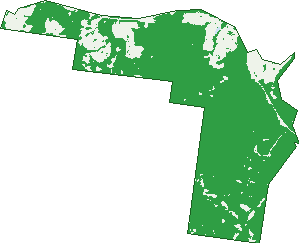
Green: 10 m cells where trees dominate, satellite 2021. Blue: water. The line is the suburb boundary.
| Canopy share, 1 m canopy height map, 2020 | 52.4% |
|---|---|
| Land with trees, 10 m satellite map, 2021 | 83.0% |
Demographics
Unemployment 5.3% · Labour-force participation 75.5%
Population by age in Kirkwood
| 0-4 | 270 |
|---|---|
| 5-14 | 503 |
| 15-19 | 178 |
| 20-24 | 149 |
| 25-34 | 488 |
| 35-44 | 418 |
| 45-54 | 254 |
| 55-64 | 167 |
| 65-74 | 69 |
| 75-84 | 17 |
| 85+ | 4 |
Dwelling types in Kirkwood
| House | 778 |
|---|---|
| Townhouse | 20 |
| Apartment | 0 |
| Other | 0 |
Households by weekly income in Kirkwood
| <$650 | 56 |
|---|---|
| $650-1,499 | 143 |
| $1,500-2,999 | 292 |
| $3,000+ | 229 |
Top ancestries in Kirkwood
| Australian | 997 |
|---|---|
| English | 844 |
| Other | 243 |
| Scottish | 201 |
| Irish | 182 |
| German | 165 |
Housing tenure in Kirkwood
| Owned | 70 |
|---|---|
| Mortgage | 338 |
| Rented | 379 |
| Other | 3 |
Cars per household in Kirkwood
| 0 | 10 |
|---|---|
| 1 | 219 |
| 2 | 407 |
| 3 | 110 |
| 4+ | 44 |
Commute to work in Kirkwood
| Car | 1,000 |
|---|---|
| Train | 0 |
| Bus | 10 |
| Tram/ferry | 0 |
| Walked | 7 |
| Bicycle | 3 |
| Home | 55 |
Top countries of birth in Kirkwood
| Philippines | 101 |
|---|---|
| South Africa | 90 |
| New Zealand | 89 |
| India | 57 |
| England | 36 |
| Pakistan | 15 |
Languages used at home in Kirkwood
| Afrikaans | 57 |
|---|---|
| Tagalog | 46 |
| Filipino | 40 |
| Hindi | 23 |
| Tamil | 21 |
| Urdu | 18 |
Birds & Wildlife Nearby
24,895 bird observations recorded near Kirkwood — most often seen:
- Rainbow Lorikeet (1,602)
- Torresian Crow (1,559)
- Laughing Kookaburra (1,223)
- Pacific Black Duck (1,109)
- Brown Honeyeater (1,106)
- Dusky Moorhen (1,076)
- Peaceful Dove (1,073)
- Willie Wagtail (1,043)
- Blue-faced Honeyeater (988)
- Double-barred Finch (944)
- House Sparrow (777)
- Australian Magpie (773)
- Nutmeg Munia (765)
Show all 30 birds recorded near Kirkwood
- Little Friarbird (759)
- Galah (730)
- Australasian Purple Swamphen (723)
- Australian Wood Duck (717)
- Little Pied Cormorant (714)
- Magpie-lark (710)
- Australasian Darter (683)
- Australasian Figbird (670)
- Little Black Cormorant (663)
- Spotted Turtle-dove (627)
- Welcome Swallow (577)
- Black-faced Cuckoo-shrike (568)
- Eurasian Coot (562)
- Hardhead (558)
- Striated Pardalote (546)
- Australian Brush-turkey (526)
- Scaly-breasted Lorikeet (524)
Sightings reported by observers, not a survey, so the counts show what people record rather than what lives here. Source: Atlas of Living Australia.
Nearby Suburbs
The closest suburbs to Kirkwood:
- New Auckland (1.4 km)
- Clinton (2.2 km)
- Telina (2.5 km)
- Kin Kora (2.7 km)
- Byellee (3.2 km)
- Beecher (3.4 km)
- Sun Valley (3.6 km)
- Toolooa (4.2 km)
Embed this suburb
Add this free Kirkwood stat card to your own site — just copy the code:
Preview:
Cite this page
Quoting these figures? Copy the credit line:
Keep an eye on Kirkwood
One email when this data meaningfully changes — new census figures, prices, rankings. No spam, unsubscribe anytime.
Streets
- Amber Street (11)
- Avocet Road (10)
- Becker Street (8)
- Blackburn Court (14)
- Bottlebrush Drive (31)
- Boundary Road (2)
- Bragg Court (22)
- Briffney Street (62)
- Bufflehead Road (35)
- Bukkan Road (2)
- Carlsson Place (15)
- Cornforth Crescent (52)
- Deveney Drive (22)
- Eccles Close (6)
- Eucalyptus Place (18)
- Florey Place (33)
- Forest Springs Drive (12)
- Grasstree Crescent (29)
- Greengard Place (13)
- Gumnut Place (13)
- Haddock Drive (5)
- Iris Road (57)
- Kandel Court (18)
- Karloom Close (4)
- Kilby Road (4)
- Kirkwood Road (20)
- Koowin Drive (60)
- Lavender Boulevard (6)
- Liriope Drive (43)
- Markowitz Place (11)
- Oakdale Place (8)
- Orchard Drive (24)
- Oystercatcher Road (31)
- Parkway Crescent (27)
- Peter Corones Drive (33)
- Petrel Street (23)
- Phelps Circuit (24)
- Redgum Drive (25)
- Scholes Way (15)
- Seagull Boulevard (43)
- Sheathbill Circuit (3)
- Skyline Drive (7)
- Spence Court (27)
- Starling Drive (1)
- Takoko Place (13)
- Teatree Street (2)
- Telopea Place (34)
- Winpara Drive (28)
- Woodland Court (36)