Karalee QLD 4306
2,307 addresses · 114 streets
Blair Electorate › Ipswich LGA › Karalee · 22 km from Brisbane
📦 Thinking of moving here? Read the Karalee moving guide

Living Here
Karalee is a suburb of Queensland, home to about 5,521 people, with a median age of 37. The typical household earns around $2,559 a week, with median rent near $400 a week. Most homes are houses. About 86% of households own their home and 13% rent. Most workers drive to work. Common community backgrounds include English, Australian, Irish. On the ABS socio-economic scale it sits in decile 9 of 10 nationally — a relatively advantaged area.
Over time — Census 2001 → 2021
Dashed line: district figures for the Karalee - Barellan Point statistical area (SA2), the smallest area the ABS published before 2011. Solid line: Karalee itself.
Getting Around & Local Services
3 cafés & restaurants
3 supermarkets
3 Catholic churches
1 medical clinic
1 childcare centre
1 post office
2 golf clubs
1 bakery
3 hardware stores
1 mechanic
1 electrician
3 carpenters
1 place to stay
Getting around. Train station: Dinmore, 4 km south · Railway halt: Bundamba Racecourse, 6.3 km south · Ferry wharf: Riverview, 4.9 km south-east · Airport: Brisbane Airport, 35.7 km north-east.
Socio-economic Standing
Deciles from 1 (lowest) to 10 (highest), against all Australian suburbs. The overall figure weighs advantage and disadvantage together; economic resources counts income and housing, and education & jobs counts qualifications and occupation. They often differ. Source: ABS SEIFA 2021.
Tree cover
🌳 Tree canopy: 30.1% share of land under canopy · satellite map, 2020
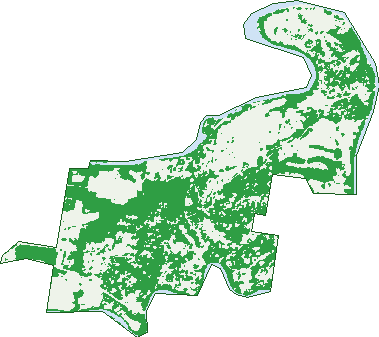
Green: 10 m cells where trees dominate, satellite 2021. Blue: water. The line is the suburb boundary.
| Canopy share, 1 m canopy height map, 2020 | 30.1% |
|---|---|
| Land with trees, 10 m satellite map, 2021 | 54.8% |
Demographics
Unemployment 3.4% · Labour-force participation 73.6%
Population by age in Karalee
| 0-4 | 384 |
|---|---|
| 5-14 | 937 |
| 15-19 | 392 |
| 20-24 | 292 |
| 25-34 | 599 |
| 35-44 | 846 |
| 45-54 | 821 |
| 55-64 | 664 |
| 65-74 | 409 |
| 75-84 | 156 |
| 85+ | 31 |
Dwelling types in Karalee
| House | 1,722 |
|---|---|
| Townhouse | 17 |
| Apartment | 12 |
| Other | 0 |
Households by weekly income in Karalee
| <$650 | 114 |
|---|---|
| $650-1,499 | 316 |
| $1,500-2,999 | 548 |
| $3,000+ | 642 |
Top ancestries in Karalee
| English | 2,458 |
|---|---|
| Australian | 2,224 |
| Irish | 659 |
| Scottish | 654 |
| German | 518 |
| Other | 326 |
Housing tenure in Karalee
| Owned | 446 |
|---|---|
| Mortgage | 1,044 |
| Rented | 229 |
| Other | 15 |
Cars per household in Karalee
| 0 | 15 |
|---|---|
| 1 | 268 |
| 2 | 795 |
| 3 | 363 |
| 4+ | 296 |
Commute to work in Karalee
| Car | 1,956 |
|---|---|
| Train | 29 |
| Bus | 4 |
| Tram/ferry | 0 |
| Walked | 19 |
| Bicycle | 0 |
| Home | 495 |
Top countries of birth in Karalee
| England | 268 |
|---|---|
| New Zealand | 167 |
| South Africa | 89 |
| Scotland | 33 |
| India | 32 |
| Zimbabwe | 27 |
Languages used at home in Karalee
| Afrikaans | 47 |
|---|---|
| Malayalam | 19 |
| Tagalog | 15 |
| Punjabi | 13 |
| Tamil | 12 |
| Persian | 10 |
Birds & Wildlife Nearby
86,038 bird observations recorded near Karalee — most often seen:
- Noisy Miner (4,358)
- Torresian Crow (4,292)
- Rainbow Lorikeet (4,152)
- Scaly-breasted Lorikeet (3,623)
- Sulphur-crested Cockatoo (3,614)
- Australian Magpie (3,598)
- Laughing Kookaburra (3,561)
- Grey Butcherbird (3,116)
- Pied Butcherbird (3,078)
- Australian Wood Duck (3,029)
- Willie Wagtail (2,994)
- Black-faced Cuckoo-shrike (2,878)
- Lewin's Honeyeater (2,838)
Show all 30 birds recorded near Karalee
- Australasian Figbird (2,724)
- Striated Pardalote (2,715)
- Eastern Whipbird (2,695)
- Pacific Black Duck (2,636)
- Bar-shouldered Dove (2,634)
- Magpie-lark (2,583)
- Brown Honeyeater (2,565)
- Red-backed Fairy-wren (2,402)
- Welcome Swallow (2,394)
- Pied Currawong (2,390)
- Masked Lapwing (2,372)
- Pale-headed Rosella (2,354)
- Noisy Friarbird (2,344)
- Blue-faced Honeyeater (2,250)
- Silvereye (1,997)
- Galah (1,946)
- Rainbow Bee-eater (1,906)
Sightings reported by observers, not a survey, so the counts show what people record rather than what lives here. Source: Atlas of Living Australia.
Nearby Suburbs
The closest suburbs to Karalee:
- Karana Downs (1.9 km)
- Barellan Point (2.2 km)
- Chuwar (3.6 km)
- Dinmore (3.9 km)
- Mount Crosby (4 km)
- North Tivoli (4.3 km)
- Anstead (4.5 km)
- Riverview (4.8 km)
Embed this suburb
Add this free Karalee stat card to your own site — just copy the code:
Preview:
Cite this page
Quoting these figures? Copy the credit line:
Keep an eye on Karalee
One email when this data meaningfully changes — new census figures, prices, rankings. No spam, unsubscribe anytime.
Streets
- Albatross Avenue (10)
- Aramac Plaza (7)
- Archer Court (10)
- Arrawatta Close (11)
- Arthur Summervilles Road (80)
- Arunta Street (23)
- Aspect Way (60)
- Balmoral Grove (23)
- Baradine Close (19)
- Barcoo Street (3)
- Bass Street (3)
- Bendemeer Street (36)
- Blaxland Street (5)
- Carbine Court (8)
- Carlock Promenade (22)
- Cononbar Place (7)
- Culgoa Street (1)
- Dan Street (32)
- Darling Court (13)
- Diamantina Circle (73)
- Doomba Place (14)
- Douglas Court (13)
- Elaine Street (32)
- Elanora Way (71)
- Elizabeth Street (10)
- Elswick Street (1)
- Encounter Street (1)
- Essex Street (23)
- Ezra Court (23)
- Fearless Court (17)
- Fitzroy Place (13)
- Forceful Crescent (8)
- Freshwater Place (11)
- Fullelove Court (7)
- Gascoyne Drive (34)
- Gayundah Street (14)
- Greenview Court (8)
- Gurners Lane (4)
- Habitat Place (16)
- Harold Summervilles Road (10)
- Heather Street (10)
- Hercules Row (1)
- Hideaway Place (8)
- Hood Street (13)
- Hume Street (16)
- Huon Drive (17)
- Iceberg Lane (7)
- Jagera Court (19)
- Joanne Street (12)
- Joyce Street (60)
- Junction Road (140)
- Kallatina Terrace (13)
- Kambu Close (31)
- Katherine Court (18)
- Krait Street (3)
- Krystyna Court (14)
- Lachlan Place (14)
- Langlands Street (12)
- Lewis Drive (42)
- Lillian Street (10)
- Lintrose Terrace (15)
- Louisa Place (18)
- Ludwig Lane (1)
- Lyndon Way (67)
- Marilyn Street (10)
- Megahran Street (4)
- Melbourne Street (42)
- Miriam Street (84)
- Mirimar Close (12)
- Mount Crosby Road (8)
- Mt Crosby Road (4)
- Myora Row (16)
- Nautilus Close (15)
- Noel Close (7)
- Noela Street (10)
- Oxley Drive (29)
- Paluma Place (18)
- Paroo Place (5)
- Patricia Street (10)
- Patterson Place (7)
- Perth Street (33)
- Phar Lap Parade (26)
- Pharlap Parade (1)
- President Circle (38)
- Queensborough Parade (36)
- Quiberon Street (11)
- Raven Court (10)
- Rea Road (9)
- Riverpark Drive (31)
- Riversleigh Court (26)
- Ronan Lane (1)
- Rowning Court (21)
- Sanctuary Place (17)
- Seahorse Court (5)
- Sealark Cove (17)
- Seiler Court (11)
- Settler Way (70)
- South Queensborough Parade (48)
- Sovereign Strait (21)
- Stanton Cross Drive (44)
- Stuart Court (6)
- Swann Street (1)
- Tallwoods Street (8)
- Tingira Avenue (1)
- Torrens Street (26)
- Venus Court (6)
- Voyager Drive (18)
- Warrego Highway (5)
- Waterfront Drive (59)
- Waterlilly Drive (34)
- Wenona Street (3)
- Wentworth Court (17)
- Willowdowns Drive (25)
- Yarra Court (4)