Ingham QLD 4850
3,384 addresses · 148 streets
Kennedy Electorate › Hinchinbrook LGA › Ingham · 1206 km from Brisbane
📦 Thinking of moving here? Read the Ingham moving guide

Living Here
Ingham is a suburb of Queensland, home to about 4,455 people, with a median age of 49. The typical household earns around $1,028 a week, with median rent near $210 a week. Most homes are houses. About 64% of households own their home and 34% rent. Most workers drive to work. Common community backgrounds include Australian, English, Italian. On the ABS socio-economic scale it sits in decile 1 of 10 nationally — a more disadvantaged area.
Over time — Census 2001 → 2021
Dashed line: district figures for the Ingham statistical area (SA2), the smallest area the ABS published before 2011. Solid line: Ingham itself.
Getting Around & Local Services
3 cafés & restaurants
2 supermarkets
1 pharmacy
2 doctors & medical clinics
1 dentist
1 optometrist
1 hospital
2 libraries
1 post office
5 service stations
1 golf club
1 bakery
1 butcher
1 hardware store
1 hairdresser
1 mechanic
Getting around. Train station: Ingham, 650 m north-east · Airport: Ingham Airport, 2 km south-west.
Socio-economic Standing
Deciles from 1 (lowest) to 10 (highest), against all Australian suburbs. The overall figure weighs advantage and disadvantage together; economic resources counts income and housing, and education & jobs counts qualifications and occupation. They often differ. Source: ABS SEIFA 2021.
Tree cover
🌳 Tree canopy: 11.7% share of land under canopy · satellite map, 2020
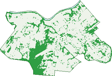
Green: 10 m cells where trees dominate, satellite 2021. Blue: water. The line is the suburb boundary.
| Canopy share, 1 m canopy height map, 2020 | 11.7% |
|---|---|
| Land with trees, 10 m satellite map, 2021 | 24.3% |
Demographics
Unemployment 5.9% · Labour-force participation 49.5%
Population by age in Ingham
| 0-4 | 206 |
|---|---|
| 5-14 | 494 |
| 15-19 | 233 |
| 20-24 | 222 |
| 25-34 | 452 |
| 35-44 | 398 |
| 45-54 | 521 |
| 55-64 | 647 |
| 65-74 | 562 |
| 75-84 | 466 |
| 85+ | 254 |
Dwelling types in Ingham
| House | 1,567 |
|---|---|
| Townhouse | 141 |
| Apartment | 94 |
| Other | 10 |
Households by weekly income in Ingham
| <$650 | 479 |
|---|---|
| $650-1,499 | 616 |
| $1,500-2,999 | 403 |
| $3,000+ | 158 |
Top ancestries in Ingham
| Australian | 1,441 |
|---|---|
| English | 1,420 |
| Italian | 1,260 |
| Irish | 399 |
| Ancestry NS | 392 |
| Aboriginal | 368 |
Housing tenure in Ingham
| Owned | 782 |
|---|---|
| Mortgage | 342 |
| Rented | 595 |
| Other | 48 |
Cars per household in Ingham
| 0 | 175 |
|---|---|
| 1 | 689 |
| 2 | 620 |
| 3 | 214 |
| 4+ | 78 |
Commute to work in Ingham
| Car | 1,317 |
|---|---|
| Train | 0 |
| Bus | 12 |
| Tram/ferry | 0 |
| Walked | 94 |
| Bicycle | 15 |
| Home | 73 |
Top countries of birth in Ingham
| Italy | 142 |
|---|---|
| Philippines | 48 |
| England | 44 |
| New Zealand | 36 |
| Netherlands | 16 |
| Papua New Guinea | 14 |
Languages used at home in Ingham
| Italian | 169 |
|---|---|
| Filipino | 21 |
| Australian Indigenous | 13 |
| German | 9 |
| Spanish | 9 |
| Mandarin | 8 |
Birds & Wildlife Nearby
57,494 bird observations recorded near Ingham — most often seen:
- Crimson Finch (2,794)
- Comb-crested Jacana (2,654)
- Masked Lapwing (2,640)
- Willie Wagtail (2,467)
- Peaceful Dove (2,250)
- Australasian Darter (2,235)
- Pacific Black Duck (2,101)
- Yellow Honeyeater (2,064)
- Brown Honeyeater (2,005)
- Australian White Ibis (2,000)
- Common Myna (1,973)
- Bar-shouldered Dove (1,958)
- Green Pygmy-goose (1,942)
Show all 30 birds recorded near Ingham
- White-breasted Woodswallow (1,921)
- Red-backed Fairy-wren (1,870)
- Great Egret (1,837)
- White-gaped Honeyeater (1,732)
- Intermediate Egret (1,712)
- Magpie-lark (1,704)
- White-browed Robin (1,702)
- Brown-backed Honeyeater (1,697)
- Wandering Whistling-duck (1,675)
- Little Pied Cormorant (1,644)
- Magpie Goose (1,601)
- Welcome Swallow (1,587)
- Forest Kingfisher (1,583)
- Red-browed Finch (1,570)
- Rufous Whistler (1,531)
- Australasian Figbird (1,529)
- Rainbow Lorikeet (1,516)
Sightings reported by observers, not a survey, so the counts show what people record rather than what lives here. Source: Atlas of Living Australia.
Nearby Suburbs
The closest suburbs to Ingham:
- Victoria Plantation (4.8 km)
- Blackrock (5.4 km)
- Gairloch (5.4 km)
- Foresthome (6.1 km)
- Toobanna (6.6 km)
- Hawkins Creek (7.9 km)
- Braemeadows (9.2 km)
- Trebonne (9.4 km)
Embed this suburb
Add this free Ingham stat card to your own site — just copy the code:
Preview:
Cite this page
Quoting these figures? Copy the credit line:
Keep an eye on Ingham
One email when this data meaningfully changes — new census figures, prices, rankings. No spam, unsubscribe anytime.
Streets
- Abbott Street (33)
- Allingham Street (14)
- Alm Street (6)
- Alston Street (1)
- Ann Street (20)
- Ardrossan Street (24)
- Atkinson Street (48)
- Atzinis Lane (3)
- Authurs Street (17)
- Badila Street (19)
- Barnes Street (4)
- Berwick Street (50)
- Bird Street (10)
- Blackburn Street (6)
- Blamey Street (17)
- Borello Street (6)
- Boyd Street (29)
- Bruce Highway (22)
- Bruce Highway S (2)
- Burke Street (25)
- Cartwright Street (110)
- Cassady Street (98)
- Cemetery Road (19)
- Challands Street (28)
- Chamberlain Street (16)
- Christie Street (12)
- Churchill Street (12)
- Clay Street (30)
- Clement Street (2)
- Coates Road (8)
- Cockrell Street (6)
- Conroy Street (16)
- Cooper Street (47)
- Covell Street (20)
- Cowley Street (6)
- Dalrymple Street (19)
- Davidson Street (91)
- Dickson Street (37)
- Druery Street (2)
- Duffy Street (8)
- Dutton Street (49)
- Eleanor Street (36)
- Enterprise Street (1)
- Fairford Road (59)
- Fanning Street (30)
- Fisher Street (22)
- Flynn Street (2)
- Forest Beach Road (4)
- Forest Home Road (5)
- Forgan Street (31)
- Forrest Beach Road (2)
- Francis Street (13)
- Fraser Street (32)
- Garbutt Street (38)
- Gard Street (8)
- Gardiner Street (24)
- Gedge Street (7)
- Gedges Crossing Road (5)
- George Street (22)
- Giugni Street (17)
- Glover Street (5)
- Gort Street (36)
- Gough Street (8)
- Griffith Street (23)
- Grimes Street (6)
- Haig Street (12)
- Halifax Road (50)
- Hamleigh Road (16)
- Hardy Street (49)
- Harvey Street (1)
- Hawkins Street (45)
- Heard Street (20)
- Hecht Street (8)
- Herbert Street (137)
- Hopkins Street (6)
- Hume Street (2)
- Hunter Street (14)
- Industrial Avenue (1)
- Jane Street (1)
- Jesson Street (26)
- Kehl Street (6)
- King Street (9)
- Lannercost Street (163)
- Larsens Road (1)
- Leckie Street (5)
- Lehane Street (4)
- Lynch Street (25)
- Lynn Street (53)
- Lyons Street (16)
- Macdonald Street (39)
- Macrossan Avenue (11)
- Mahoney Street (9)
- Marco Court (6)
- Maria Court (13)
- Marina Parade (67)
- Markey Street (11)
- Martin Street (1)
- Mcilwraith Street (120)
- Mckenzie Street (11)
- Mcleod Street (8)
- Menzies Street (11)
- Miles Street (57)
- Morehead Street (30)
- Moretti Street (22)
- Morris Street (3)
- Morrissey Street (18)
- Mylrea Street (24)
- Neame Street (41)
- Neilsen Street (6)
- New Cemetery Road (2)
- O'malley Street (3)
- Origlasso Street (42)
- Palm Avenue (36)
- Palm Terrace (38)
- Palmer Street (38)
- Perkins Street (24)
- Philp Street (36)
- Pindar Street (22)
- Pump Station Road (4)
- Renouf Street (17)
- Roati Street (20)
- Robertson Street (6)
- Row Street (22)
- Rutledge Street (29)
- Sachs Lane (1)
- Scott Court (13)
- Simpson Street (14)
- Sir Arthur Fadden Parade (40)
- Skinner Street (12)
- Sportsman Parade (3)
- Stallan Street (26)
- Stone Street (32)
- Swarbrick (11)
- Swarbrick Street (11)
- Tilley Street (1)
- Townsend Street (12)
- Townsville Road (58)
- Trebonne Road (4)
- Triton Street (2)
- Trojan Street (3)
- Tully Street (19)
- Venables Street (9)
- Victoria Mill Road (59)
- Victoria Street (1)
- Von Alpin Street (8)
- Warren Street (56)
- White Street (13)
- Yeldham Street (31)