Gympie QLD 4570
7,848 addresses · 314 streets
Wide Bay Electorate › Gympie LGA › Gympie · 147 km from Brisbane
📦 Thinking of moving here? Read the Gympie moving guide

Living Here
Gympie is a suburb of Queensland, home to about 11,355 people, with a median age of 42. The typical household earns around $1,022 a week, with median rent near $295 a week. Most homes are houses. About 60% of households own their home and 38% rent. Most workers drive to work. Common community backgrounds include English, Australian, Irish. On the ABS socio-economic scale it sits in decile 1 of 10 nationally — a more disadvantaged area.
Over time — Census 2001 → 2021
Dashed line: district figures for the Gympie - North statistical area (SA2), the smallest area the ABS published before 2011. Solid line: Gympie itself.
Getting Around & Local Services
16 schools
4 supermarkets
1 pharmacy
1 physiotherapist
1 hospital
2 childcare & kindergartens
1 library
1 post office
5 service stations
2 golf clubs
1 bakery
3 hardware stores
1 beauty salon
Getting around. Train station: Gympie North, 3.2 km north-east · Railway halt: Monkland, 3.5 km south-east · Airport: Gympie Airport, 12.2 km south.
Socio-economic Standing
Deciles from 1 (lowest) to 10 (highest), against all Australian suburbs. The overall figure weighs advantage and disadvantage together; economic resources counts income and housing, and education & jobs counts qualifications and occupation. They often differ. Source: ABS SEIFA 2021.
Tree cover
🌳 Tree canopy: 13% share of land under canopy · satellite map, 2020
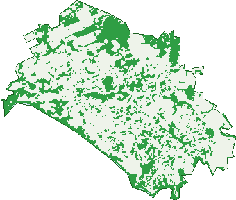
Green: 10 m cells where trees dominate, satellite 2021. Blue: water. The line is the suburb boundary.
| Canopy share, 1 m canopy height map, 2020 | 13.0% |
|---|---|
| Land with trees, 10 m satellite map, 2021 | 31.0% |
Demographics
Unemployment 7% · Labour-force participation 47.9%
Population by age in Gympie
| 0-4 | 629 |
|---|---|
| 5-14 | 1,455 |
| 15-19 | 721 |
| 20-24 | 615 |
| 25-34 | 1,302 |
| 35-44 | 1,231 |
| 45-54 | 1,303 |
| 55-64 | 1,379 |
| 65-74 | 1,307 |
| 75-84 | 941 |
| 85+ | 478 |
Dwelling types in Gympie
| House | 3,886 |
|---|---|
| Townhouse | 472 |
| Apartment | 198 |
| Other | 15 |
Households by weekly income in Gympie
| <$650 | 1,202 |
|---|---|
| $650-1,499 | 1,710 |
| $1,500-2,999 | 1,067 |
| $3,000+ | 303 |
Top ancestries in Gympie
| English | 4,955 |
|---|---|
| Australian | 4,911 |
| Irish | 1,301 |
| Scottish | 1,213 |
| German | 744 |
| Ancestry NS | 726 |
Housing tenure in Gympie
| Owned | 1,495 |
|---|---|
| Mortgage | 1,221 |
| Rented | 1,720 |
| Other | 61 |
Cars per household in Gympie
| 0 | 413 |
|---|---|
| 1 | 1,930 |
| 2 | 1,517 |
| 3 | 438 |
| 4+ | 207 |
Commute to work in Gympie
| Car | 3,121 |
|---|---|
| Train | 0 |
| Bus | 23 |
| Tram/ferry | 5 |
| Walked | 139 |
| Bicycle | 12 |
| Home | 221 |
Top countries of birth in Gympie
| England | 303 |
|---|---|
| New Zealand | 271 |
| Philippines | 89 |
| India | 59 |
| Germany | 42 |
| United States | 38 |
Languages used at home in Gympie
| Tagalog | 41 |
|---|---|
| Mandarin | 40 |
| German | 27 |
| Punjabi | 25 |
| Malayalam | 25 |
| Vietnamese | 23 |
Birds & Wildlife Nearby
11,113 bird observations recorded near Gympie — most often seen:
- Australian White Ibis (791)
- Dusky Moorhen (650)
- Black Swan (608)
- Pacific Black Duck (592)
- Magpie-lark (523)
- Rainbow Lorikeet (465)
- Magpie Goose (458)
- Little Pied Cormorant (417)
- Willie Wagtail (406)
- Torresian Crow (404)
- Little Black Cormorant (393)
- Hardhead (386)
- Noisy Miner (355)
Show all 30 birds recorded near Gympie
- Australasian Purple Swamphen (351)
- Welcome Swallow (349)
- Australian Wood Duck (347)
- Little Corella (347)
- Australasian Darter (312)
- Australian Magpie (309)
- Brown Honeyeater (290)
- Australasian Figbird (287)
- Little Friarbird (255)
- Blue-faced Honeyeater (251)
- Australian Torresian Crow (245)
- Southern Masked Lapwing (241)
- Eastern Rainbow Lorikeet (239)
- Southern Magpie-lark (223)
- Spotted Turtle-dove (209)
- Masked Lapwing (207)
- Eastern Australian Magpie (203)
Sightings reported by observers, not a survey, so the counts show what people record rather than what lives here. Source: Atlas of Living Australia.
Nearby Suburbs
The closest suburbs to Gympie:
- Victory Heights (2.2 km)
- Araluen (3 km)
- Two Mile (3.1 km)
- Southside (3.4 km)
- Monkland (3.5 km)
- Banks Pocket (3.7 km)
- Widgee Crossing North (4 km)
- Glanmire (5.2 km)
Embed this suburb
Add this free Gympie stat card to your own site — just copy the code:
Preview:
Cite this page
Quoting these figures? Copy the credit line:
Keep an eye on Gympie
One email when this data meaningfully changes — new census figures, prices, rankings. No spam, unsubscribe anytime.
Streets
- Ada Street (94)
- Adams Street (54)
- Albatross Court (10)
- Alenola Street (8)
- Alexander Place (13)
- Alfred Street (44)
- Alice Street (9)
- Alma Street (39)
- Amalie Place (8)
- Amber Court (23)
- Amy Street (13)
- Andrew Street (15)
- Ann Street (11)
- Aparima Court (24)
- Apollonian Vale (33)
- Ashford Road (47)
- Ashgrove Way (16)
- Aspen Court (6)
- Austin Lane (1)
- Baker Street (15)
- Banks Pocket Road (23)
- Banksia Drive (57)
- Barter Street (77)
- Batchelor Road (19)
- Bath Terrace (23)
- Beaconsfield Street (13)
- Begonia Close (5)
- Bellflower Place (9)
- Benbullen Court (18)
- Bennett Street (13)
- Bent Lane (2)
- Bent Street (20)
- Beresford Crescent (31)
- Berrie Street (25)
- Bielby Court (5)
- Birdie Crescent (8)
- Blake Street (9)
- Bligh Street (40)
- Bonnick Road (8)
- Bort Road (3)
- Bottlebrush Place (10)
- Bowen Lane (8)
- Brewery Road (11)
- Bright Street (6)
- Brisbane Road (23)
- Bruce Highway (1)
- Buchanan Street (7)
- Buchannan Street (7)
- Buggy Court (10)
- Bunya Pine Court (8)
- Butler Street (22)
- Caddie Court (5)
- Caledonian Hill (29)
- Calton Circle (6)
- Calton Hill Road (7)
- Calton Terrace (45)
- Camphor Laurel Court (23)
- Campus Close (12)
- Candlewood Court (2)
- Carey Street (2)
- Carrington Avenue (32)
- Cartwright Road (64)
- Cassia Court (9)
- Cedar Court (17)
- Centenary Close (9)
- Chalk Close (5)
- Channon Street (103)
- Chapple Lane (15)
- Chapple Street (23)
- Chatsworth Road (29)
- Church Street (27)
- Clarke Lane (2)
- Clematis Street (53)
- Club Circle (14)
- Club Drive (37)
- Cockburn Lane (11)
- Cogan Street (20)
- Columbia Street (24)
- Compass Court (24)
- Conifer Court (7)
- Connemara Court (15)
- Cooinda Street (35)
- Coombe Street (5)
- Coop Street (14)
- Cootharaba Road (85)
- Coreen Street (1)
- Corella Court (14)
- Corella Road (100)
- Crawford Street (4)
- Crescent Road (69)
- Crestwood Court (21)
- Cross Street (16)
- Crown Road (32)
- Cullinane Street (16)
- Cummings Street (3)
- Currambine Avenue (13)
- Daisy Court (14)
- David Street (19)
- Davies Lane (9)
- Dent Lane (8)
- Derrilin Drive (21)
- Dornan Drive (9)
- Dovetail Close (4)
- Dowdle Road (3)
- Dudley Street (3)
- Duke Street (114)
- Eagle Street (3)
- Eagleview Close (7)
- Earl Street (2)
- Edward Street (14)
- Elgin Lane (1)
- Elgin Street (15)
- Elizabeth Street (43)
- Elm Place (7)
- Elworthy Street (2)
- Ethan Close (8)
- Everson Lane (7)
- Everson Road (24)
- Excelsior Road (41)
- Fairway Drive (88)
- Farleys Lane (26)
- Fauna Road (46)
- Ferguson Street (17)
- Fern Street (18)
- Firchester Court (11)
- Fisher Lane (2)
- Flynn Road (61)
- Fox Street (13)
- Foxtail Court (15)
- Friar Road (21)
- Garrick Street (51)
- Gladstone Street (15)
- Glanmire Street (19)
- Glasgow Street (29)
- Glen Eden Drive (44)
- Glynn Place (24)
- Goldfield Plaza (27)
- Golf Links Circle (61)
- Grabs Lane (4)
- Graduate Close (6)
- Graham Street (30)
- Grammar Close (8)
- Grandview Place (19)
- Graystone Court (9)
- Greenmount Street (5)
- Greystone Court (9)
- Grice Crescent (15)
- Hall Lane (24)
- Hall Street (1)
- Hambleton Road (3)
- Hamilton Road (4)
- Harkins Road (12)
- Harkins Street (13)
- Heights Drive (49)
- Henry Street (51)
- Hillview Court (19)
- Hilton Lane (1)
- Hilton Road (75)
- Horseshoe Bend (80)
- Hughes Terrace (23)
- Hyne Street (17)
- Iron Street (24)
- Ironwood Close (6)
- Isabel Court (19)
- Jane Street (32)
- Jardine Close (14)
- Jaryd Place (24)
- John Street (9)
- Julia Street (6)
- Kerr Place (4)
- Kidgell Street (32)
- King Road (3)
- King Street (56)
- Kitts Lane (7)
- Lachlan Place (7)
- Lady Mary Terrace (27)
- Laurie Lane (6)
- Lawrence Lane (1)
- Lawrence Street (71)
- Leavinia Street (23)
- Lillis Road (27)
- Lime Street (6)
- Lister Close (20)
- Little Channon Street (4)
- Louisa Lane (30)
- Louisa Street (72)
- Lucknow Street (9)
- Lyden Court (20)
- Madonna Place (10)
- Mahogany Way (29)
- Maidment Court (15)
- Main Street (32)
- Malabar Drive (18)
- Maori Lane (6)
- Mark Lane (4)
- Mary Street (286)
- Mchugh Court (1)
- Mclellan Terrace (20)
- Mcleod Lane (2)
- Mcleod Street (2)
- Mellor Street (67)
- Meridian Terrace (21)
- Mill Street (2)
- Monkland Street (60)
- Morris Street (4)
- Mount Pleasant Road (61)
- Mulcahy Terrace (37)
- Musgrave Street (75)
- Myall Lane (2)
- Myall Street (94)
- Nahrunda Lane (1)
- Nash Street (49)
- Navigator Close (5)
- Nelson Lane (1)
- Nelson Road (29)
- New Zealand Lane (9)
- New Zealand Street (3)
- Norman Street (35)
- O'connell Street (95)
- Oak Street (94)
- Old Maryborough Road (162)
- Outlook Close (12)
- Pacey Street (16)
- Palm Crescent (1)
- Pandanus Street (59)
- Park Lane (8)
- Park Terrace (10)
- Parsons Road (51)
- Perseverance Street (19)
- Phoenix Lane (17)
- Phoenix Street (8)
- Pilcher Lane (3)
- Pine Street (134)
- Pinewood Avenue (22)
- Poinciana Lane (18)
- Pollock Lane (8)
- Pollock Street (13)
- Popes Road (30)
- Potter Street (7)
- Power Street (24)
- Primrose Court (28)
- Pring Lane (5)
- Pringle Court (26)
- Quamby Court (12)
- Queen Street (24)
- Queens Park Road (4)
- Randall Street (6)
- Ranson Road (82)
- Ray Street (29)
- Red Hill Road (65)
- Reef Street (83)
- Ridgeview Drive (67)
- Rifle Range Road (194)
- River Road (157)
- River Terrace (3)
- Riverstone Close (8)
- Rose Street (8)
- Rosella Close (4)
- Rowe Street (11)
- Saint Andrews Crescent (39)
- Saleyard Road (2)
- Scholar Close (12)
- School Street (1)
- Schumann Lane (3)
- Scott Road (9)
- Settlers Close (5)
- Shanks Street (24)
- Shayduk Close (35)
- Shields Street (34)
- Short Street (10)
- Skyline Terrace (28)
- Smalley Place (11)
- Smithfield Street (3)
- Smyth Street (38)
- Somerset Street (25)
- Sorrel Street (15)
- Spicer Street (19)
- Spring Road (41)
- Sproule Road (57)
- Stanley Lane (31)
- Stanley Street (36)
- Station Road (42)
- Stewart Terrace (59)
- Stone Street (5)
- Struan Crescent (16)
- Stuart Street (9)
- Teal Close (5)
- Thomas Street (27)
- Tozer Lane (16)
- Tozer Park Road (26)
- Tozer Street (37)
- Tucker Street (61)
- Tweed Lane (12)
- Venardos Drive (12)
- Victoria Road (1)
- Victory Lane (3)
- Victory Street (23)
- Violet Street (44)
- Voyager Place (17)
- Wagtail Crescent (20)