Forrest Beach QLD 4850
1,178 addresses · 61 streets
Kennedy Electorate › Hinchinbrook LGA › Forrest Beach · 1193 km from Brisbane
📦 Thinking of moving here? Read the Forrest Beach moving guide

Living Here
Forrest Beach is a suburb of Queensland, home to about 1,364 people, with a median age of 57. The typical household earns around $935 a week, with median rent near $240 a week. Most homes are houses. About 76% of households own their home and 23% rent. Most workers drive to work. Common community backgrounds include English, Australian, Irish. On the ABS socio-economic scale it sits in decile 2 of 10 nationally — a more disadvantaged area.
Over time — Census 2001 → 2021
Dashed line: district figures for the Ingham Region statistical area (SA2), the smallest area the ABS published before 2011. Solid line: Forrest Beach itself.
Getting Around & Local Services
1 school
1 pharmacy
1 hospital
1 hairdresser
1 place to stay
Getting around. Airport: Ingham Airport, 16.1 km west.
Socio-economic Standing
Deciles from 1 (lowest) to 10 (highest), against all Australian suburbs. The overall figure weighs advantage and disadvantage together; economic resources counts income and housing, and education & jobs counts qualifications and occupation. They often differ. Source: ABS SEIFA 2021.
Tree cover
🌳 Tree canopy: 26.1% share of land under canopy · satellite map, 2020
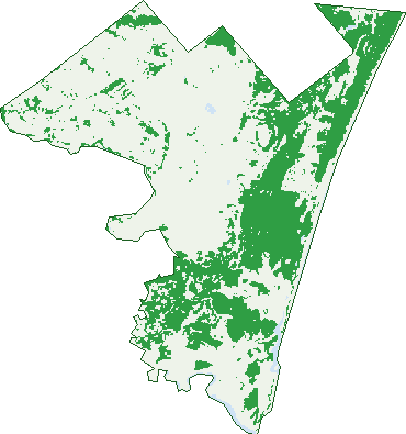
Green: 10 m cells where trees dominate, satellite 2021. Blue: water. The line is the suburb boundary.
| Canopy share, 1 m canopy height map, 2020 | 26.1% |
|---|---|
| Land with trees, 10 m satellite map, 2021 | 33.3% |
Demographics
Unemployment 4.9% · Labour-force participation 42.1%
Population by age in Forrest Beach
| 0-4 | 50 |
|---|---|
| 5-14 | 142 |
| 15-19 | 59 |
| 20-24 | 39 |
| 25-34 | 79 |
| 35-44 | 99 |
| 45-54 | 155 |
| 55-64 | 277 |
| 65-74 | 286 |
| 75-84 | 142 |
| 85+ | 39 |
Dwelling types in Forrest Beach
| House | 528 |
|---|---|
| Townhouse | 35 |
| Apartment | 6 |
| Other | 9 |
Households by weekly income in Forrest Beach
| <$650 | 159 |
|---|---|
| $650-1,499 | 208 |
| $1,500-2,999 | 130 |
| $3,000+ | 40 |
Top ancestries in Forrest Beach
| English | 556 |
|---|---|
| Australian | 458 |
| Irish | 186 |
| Italian | 177 |
| Scottish | 160 |
| Ancestry NS | 121 |
Housing tenure in Forrest Beach
| Owned | 286 |
|---|---|
| Mortgage | 145 |
| Rented | 132 |
| Other | 3 |
Cars per household in Forrest Beach
| 0 | 18 |
|---|---|
| 1 | 230 |
| 2 | 220 |
| 3 | 70 |
| 4+ | 31 |
Commute to work in Forrest Beach
| Car | 360 |
|---|---|
| Train | 0 |
| Bus | 5 |
| Tram/ferry | 0 |
| Walked | 22 |
| Bicycle | 0 |
| Home | 19 |
Top countries of birth in Forrest Beach
| England | 57 |
|---|---|
| New Zealand | 29 |
| Italy | 12 |
| Canada | 8 |
| China | 8 |
| Netherlands | 7 |
Languages used at home in Forrest Beach
| Mandarin | 5 |
|---|---|
| Italian | 4 |
| Australian Indigenous | 3 |
Birds & Wildlife Nearby
20,526 bird observations recorded near Forrest Beach — most often seen:
- Masked Lapwing (1,329)
- Southern Willie Wagtail (1,121)
- Comb-crested Jacana (1,038)
- Magpie Goose (998)
- Australian White Ibis (941)
- Rainbow Bee-eater (883)
- Fairy Martin (851)
- Crimson Finch (820)
- Great Egret (801)
- Intermediate Egret (787)
- White-breasted Woodswallow (757)
- Australasian Darter (700)
- Eastern Peaceful Dove (683)
Show all 30 birds recorded near Forrest Beach
- White-gaped Honeyeater (664)
- Bar-shouldered Dove (618)
- Straw-necked Ibis (588)
- North-eastern Golden-headed Cisticola (573)
- Cattle Egret (541)
- Pacific Black Duck (524)
- Australasian Grebe (522)
- Royal Spoonbill (508)
- Southern Rufous Whistler (508)
- Black-fronted Dotterel (493)
- Green Pygmy-goose (493)
- Black Kite (485)
- Whistling Kite (484)
- Whiskered Tern (468)
- Eastern Brown Honeyeater (467)
- Little Pied Cormorant (450)
- Brolga (431)
Sightings reported by observers, not a survey, so the counts show what people record rather than what lives here. Source: Atlas of Living Australia.
Nearby Suburbs
The closest suburbs to Forrest Beach:
- Braemeadows (8 km)
- Taylors Beach (9.4 km)
- Blackrock (11.4 km)
- Orient (11.5 km)
- Victoria Plantation (11.5 km)
- Cordelia (12.5 km)
- Halifax (14 km)
- Foresthome (14.3 km)
Embed this suburb
Add this free Forrest Beach stat card to your own site — just copy the code:
Preview:
Cite this page
Quoting these figures? Copy the credit line:
Keep an eye on Forrest Beach
One email when this data meaningfully changes — new census figures, prices, rankings. No spam, unsubscribe anytime.
Streets
- Acacia Street (26)
- Allamanda Avenue (47)
- Ash Street (1)
- Baileyana Street (9)
- Bamboo Street (1)
- Banksia Street (27)
- Bauhinia Street (20)
- Beatts Road (114)
- Bellbird Close (16)
- Bill Johnson Drive (32)
- Blackbean Street (21)
- Bloodwood Street (2)
- Bluegum Street (5)
- Bosworths Road (7)
- Bottlebrush Street (48)
- Candlenut Street (19)
- Cashew Close (4)
- Cassia Street (32)
- Cedar Street (47)
- Chestnut Street (20)
- Coconut Lane (2)
- Coconut Street (7)
- Coral Tree Court (12)
- Cypress Close (5)
- Fern Street (17)
- Forrest Drive (39)
- Forrest Lane (2)
- Grevillea Street (35)
- Grey Gum Court (10)
- Hibiscus Street (19)
- Holly Street (2)
- Ingham - Forrest Beach Road (14)
- Jacaranda Street (6)
- Jasmine Close (11)
- Lantana Street (6)
- Leichhardt Street (81)
- Lillypilly Court (7)
- Macadamia Street (8)
- Magnolia Court (15)
- Mahogany Drive (20)
- Mango Tree Court (11)
- Maple Street (9)
- Marginata Court (16)
- Melaleuca Close (18)
- Mistletoe Street (19)
- Moreton Bay Street (18)
- Orchid Street (6)
- Palm Street (17)
- Pandanus Street (30)
- Pangola Street (6)
- Pine Street (6)
- Poppis Road (7)
- Red Gum Court (9)
- Rosella Street (23)
- She Oak Street (1)
- Staghorn Street (8)
- Tamarind Court (14)
- The Esplanade (18)
- Wattle Street (83)
- Whiteapple Street (19)
- Willow Street (24)