Eagle Farm QLD 4009
935 addresses · 43 streets
Lilley Electorate › Brisbane LGA › Eagle Farm · 8 km from Brisbane
📦 Thinking of moving here? Read the Eagle Farm moving guide

Living Here
Eagle Farm is a suburb of Queensland, home to about 11 people, with a median age of 38. The typical household earns around $824 a week, with median rent near $450 a week. About 0% of households own their home and 100% rent. Most workers drive to work. Common community backgrounds include English, Ancestry NS, Australian. On the ABS socio-economic scale it sits in decile 10 of 10 nationally — a relatively advantaged area.
Getting Around & Local Services
1 pharmacy
4 doctors & medical clinics
2 physiotherapists
24 hospitals
- Nundah Community Health Centre
- Rosemount Hospital
- Royal Brisbane and Women’s Hospital
- Saint Vincent's Private Hospital Brisbane
- St Andrews War Memorial Private Hospital
- Brisbane Private Hospital
- Belmont Private Hospital
- St Vincent's Private Hospital Northside
- The Prince Charles Hospital
- Mater Private Hospital
3 childcare & kindergartens
3 post offices
1 bakery
1 hairdresser
Getting around. Train station: Doomben, 1.5 km west · Bus interchange: Toombul Shopping Centre interchange, 4 km north-west · Ferry wharf: Northshore Hamilton Ferry Terminal, 1.5 km south · Airport: Brisbane Airport, 6.7 km north-east.
Socio-economic Standing
Deciles from 1 (lowest) to 10 (highest), against all Australian suburbs. The overall figure weighs advantage and disadvantage together; economic resources counts income and housing, and education & jobs counts qualifications and occupation. They often differ. Source: ABS SEIFA 2021.
Tree cover
🌳 Tree canopy: 5.2% share of land under canopy · satellite map, 2020
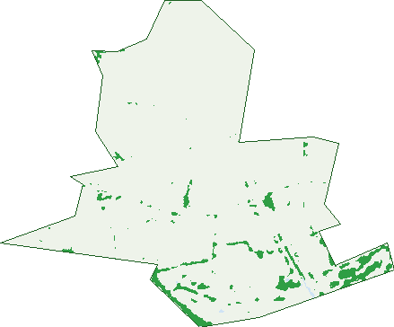
Green: 10 m cells where trees dominate, satellite 2021. Blue: water. The line is the suburb boundary.
| Canopy share, 1 m canopy height map, 2020 | 5.2% |
|---|---|
| Land with trees, 10 m satellite map, 2021 | 3.4% |
Demographics
Population by age in Eagle Farm
| 0-4 | 0 |
|---|---|
| 5-14 | 0 |
| 15-19 | 0 |
| 20-24 | 0 |
| 25-34 | 0 |
| 35-44 | 4 |
| 45-54 | 0 |
| 55-64 | 0 |
| 65-74 | 0 |
| 75-84 | 0 |
| 85+ | 0 |
Top ancestries in Eagle Farm
| English | 5 |
|---|---|
| Ancestry NS | 4 |
| Australian | 3 |
| Aboriginal | 0 |
| Chinese | 0 |
| Croatian | 0 |
Housing tenure in Eagle Farm
| Owned | 0 |
|---|---|
| Mortgage | 0 |
| Rented | 3 |
| Other | 0 |
Cars per household in Eagle Farm
| 0 | 0 |
|---|---|
| 1 | 3 |
| 2 | 0 |
| 3 | 0 |
| 4+ | 0 |
Commute to work in Eagle Farm
| Car | 3 |
|---|---|
| Train | 0 |
| Bus | 0 |
| Tram/ferry | 0 |
| Walked | 3 |
| Bicycle | 0 |
| Home | 0 |
Birds & Wildlife Nearby
107,280 bird observations recorded near Eagle Farm — most often seen:
- Australian White Ibis (7,025)
- Torresian Crow (6,654)
- Welcome Swallow (5,930)
- Magpie-lark (5,321)
- Willie Wagtail (4,870)
- Rainbow Lorikeet (4,433)
- Noisy Miner (4,255)
- Pacific Black Duck (4,108)
- Masked Lapwing (3,792)
- Australian Pelican (3,622)
- Brown Honeyeater (3,549)
- Little Black Cormorant (3,504)
- Tawny Grassbird (3,475)
Show all 30 birds recorded near Eagle Farm
- Superb Fairy-wren (3,394)
- Australian Magpie (3,300)
- Great Egret (3,142)
- Dusky Moorhen (3,060)
- White-faced Heron (3,005)
- Little Pied Cormorant (3,003)
- Rock Dove (2,866)
- Chestnut Teal (2,841)
- Intermediate Egret (2,684)
- Australasian Purple Swamphen (2,648)
- Black-faced Cuckoo-shrike (2,528)
- Golden-headed Cisticola (2,519)
- Australasian Figbird (2,468)
- Mangrove Gerygone (2,440)
- Common Myna (2,411)
- Royal Spoonbill (2,263)
- Straw-necked Ibis (2,170)
Sightings reported by observers, not a survey, so the counts show what people record rather than what lives here. Source: Atlas of Living Australia.
Nearby Suburbs
The closest suburbs to Eagle Farm:
Embed this suburb
Add this free Eagle Farm stat card to your own site — just copy the code:
Preview:
Cite this page
Quoting these figures? Copy the credit line:
Keep an eye on Eagle Farm
One email when this data meaningfully changes — new census figures, prices, rankings. No spam, unsubscribe anytime.
Streets
- Amy Johnson Place (15)
- Backhouse Place (5)
- Bunya Street (35)
- Chapman Place (21)
- Charles Ulm Place (7)
- Clyde Gessel Place (8)
- Clyde Gessell Place (4)
- Cullen Avenue (3)
- Cullen Avenue E (57)
- Cullen Avenue W (9)
- Curtin Avenue (1)
- Curtin Avenue E (12)
- Curtin Avenue W (45)
- Eagleview Place (32)
- Fairbairn Place (3)
- Ferrett Street (2)
- Fison Avenue E (42)
- Fison Avenue W (86)
- French Street (16)
- Harvey Street N (20)
- Harvey Street S (2)
- Holt Street (22)
- Industry Court (10)
- Kenyon Street (16)
- Kingsford Smith Drive (177)
- Lamington Avenue (13)
- Landers Pocket Road (2)
- Lavarack Avenue (90)
- Links Avenue (4)
- Links Avenue N (49)
- Links Avenue S (28)
- Raubers Road (1)
- Remora Road (1)
- Roman Street (2)
- Schneider Road (33)
- Taylor Place (3)
- Theodore Street (15)
- Tradecoast Drive (10)
- Viola Place (1)
- Violet Street (23)
- Want Street (4)
- Western Avenue (1)
- William Farrior Place (5)