Daisy Hill QLD 4127
2,911 addresses · 101 streets
Rankin Electorate › Logan LGA › Daisy Hill · 22 km from Brisbane
📦 Thinking of moving here? Read the Daisy Hill moving guide

Living Here
Daisy Hill is a suburb of Queensland, home to about 6,925 people, with a median age of 38. The typical household earns around $2,004 a week, with median rent near $400 a week. Most homes are houses. About 76% of households own their home and 24% rent. Most workers drive to work. Common community backgrounds include English, Australian, Irish. On the ABS socio-economic scale it sits in decile 8 of 10 nationally — a relatively advantaged area.
Over time — Census 2001 → 2021
Dashed line: district figures for the Daisy Hill statistical area (SA2), the smallest area the ABS published before 2011. Solid line: Daisy Hill itself.
Getting Around & Local Services
4 supermarkets
3 Catholic churches
2 pharmacies
3 doctors & medical clinics
1 optometrist
3 post offices
2 playgrounds
1 dog park
1 hairdresser
3 electricians
3 plumbers
Getting around. Train station: Loganlea, 3.9 km south · Bus interchange: Loganholme station, 3.3 km south-east · Airport: Brisbane Airport, 28.8 km north.
Socio-economic Standing
Deciles from 1 (lowest) to 10 (highest), against all Australian suburbs. The overall figure weighs advantage and disadvantage together; economic resources counts income and housing, and education & jobs counts qualifications and occupation. They often differ. Source: ABS SEIFA 2021.
Tree cover
🌳 Tree canopy: 62.6% share of land under canopy · satellite map, 2020
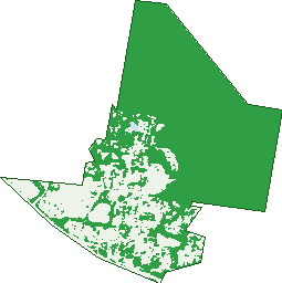
Green: 10 m cells where trees dominate, satellite 2021. Blue: water. The line is the suburb boundary.
| Canopy share, 1 m canopy height map, 2020 | 62.6% |
|---|---|
| Land with trees, 10 m satellite map, 2021 | 72.9% |
Demographics
Unemployment 5.4% · Labour-force participation 67.8%
Population by age in Daisy Hill
| 0-4 | 392 |
|---|---|
| 5-14 | 1,046 |
| 15-19 | 486 |
| 20-24 | 352 |
| 25-34 | 808 |
| 35-44 | 1,086 |
| 45-54 | 975 |
| 55-64 | 781 |
| 65-74 | 680 |
| 75-84 | 290 |
| 85+ | 36 |
Dwelling types in Daisy Hill
| House | 2,060 |
|---|---|
| Townhouse | 248 |
| Apartment | 25 |
| Other | 72 |
Households by weekly income in Daisy Hill
| <$650 | 271 |
|---|---|
| $650-1,499 | 575 |
| $1,500-2,999 | 780 |
| $3,000+ | 617 |
Top ancestries in Daisy Hill
| English | 2,607 |
|---|---|
| Australian | 2,011 |
| Other | 964 |
| Irish | 741 |
| Scottish | 675 |
| Chinese | 330 |
Housing tenure in Daisy Hill
| Owned | 677 |
|---|---|
| Mortgage | 1,141 |
| Rented | 565 |
| Other | 18 |
Cars per household in Daisy Hill
| 0 | 86 |
|---|---|
| 1 | 690 |
| 2 | 1,021 |
| 3 | 398 |
| 4+ | 188 |
Commute to work in Daisy Hill
| Car | 2,294 |
|---|---|
| Train | 7 |
| Bus | 108 |
| Tram/ferry | 0 |
| Walked | 32 |
| Bicycle | 13 |
| Home | 590 |
Top countries of birth in Daisy Hill
| New Zealand | 419 |
|---|---|
| England | 347 |
| India | 143 |
| China | 130 |
| South Korea | 111 |
| South Africa | 106 |
Languages used at home in Daisy Hill
| Mandarin | 169 |
|---|---|
| Korean | 141 |
| Punjabi | 97 |
| Cantonese | 72 |
| Spanish | 46 |
| Tagalog | 45 |
Birds & Wildlife Nearby
23,852 bird observations recorded near Daisy Hill — most often seen:
- Noisy Miner (1,582)
- Torresian Crow (1,461)
- Rainbow Lorikeet (1,408)
- Laughing Kookaburra (1,129)
- Australian White Ibis (1,087)
- Dusky Moorhen (1,043)
- Australian Magpie (1,040)
- Pacific Black Duck (983)
- Australian Wood Duck (887)
- Sulphur-crested Cockatoo (877)
- Grey Butcherbird (844)
- Pied Butcherbird (791)
- Magpie-lark (742)
Show all 30 birds recorded near Daisy Hill
- Welcome Swallow (735)
- Scarlet Honeyeater (657)
- Australasian Purple Swamphen (639)
- Striated Pardalote (627)
- Noisy Friarbird (621)
- Scaly-breasted Lorikeet (613)
- Willie Wagtail (605)
- Pied Currawong (591)
- Black-faced Cuckoo-shrike (586)
- Yellow-faced Honeyeater (571)
- Crested Pigeon (547)
- Australian Torresian Crow (546)
- Australasian Figbird (535)
- Masked Lapwing (532)
- Grey Shrike-thrush (528)
- Eastern Rainbow Lorikeet (524)
- Lewin's Honeyeater (521)
Sightings reported by observers, not a survey, so the counts show what people record rather than what lives here. Source: Atlas of Living Australia.
Nearby Suburbs
The closest suburbs to Daisy Hill:
- Slacks Creek (2.3 km)
- Springwood (2.5 km)
- Shailer Park (2.9 km)
- Meadowbrook (3.2 km)
- Priestdale (4.2 km)
- Tanah Merah (4.3 km)
- Logan Central (4.3 km)
- Kingston (4.5 km)
Embed this suburb
Add this free Daisy Hill stat card to your own site — just copy the code:
Preview:
Cite this page
Quoting these figures? Copy the credit line:
Keep an eye on Daisy Hill
One email when this data meaningfully changes — new census figures, prices, rankings. No spam, unsubscribe anytime.
Streets
- Adale Court (4)
- Aldora Street (1)
- Allamanda Drive (95)
- Azalea Avenue (20)
- Begonia Street (28)
- Bellis Street (20)
- Boronia Avenue (41)
- Brentwood Drive (57)
- Cameron Court (11)
- Campese Way (6)
- Celosia Street (20)
- Charles Glen Street (30)
- Chatswood Road (237)
- Clem Close (6)
- Clivia Crescent (66)
- Columbine Street (16)
- Conifer Street (25)
- Coolcrest Street (30)
- Crocus Street (15)
- Cupania Street (36)
- Dahlia Street (3)
- Daisy Hill Road (239)
- Dennis Vale Drive (43)
- Denton Court (6)
- Ebbro Court (5)
- Edera Court (6)
- Efymia Court (31)
- El Rancho Street (26)
- Ellendale Crescent (49)
- Elton Street (4)
- Emmet Street (15)
- Epson Court (19)
- Ermington Street (19)
- Eveleigh Street (13)
- Evenwood Street (19)
- Everest Street (24)
- Evita Court (7)
- Farne Court (17)
- Farr Court (9)
- Farr Jones Court (44)
- Farrington Court (17)
- Farrow Street (19)
- Felice Court (14)
- Forest Street (10)
- Gladewood Drive (60)
- Greenhill Grove (15)
- Gumnut Grove (6)
- Hannah Court (14)
- Harley Street (1)
- Highview Terrace (68)
- Hillside Drive (41)
- Holyoake Drive (22)
- Hyacinth Street (14)
- John Markwell Parade (47)
- John Paul Drive (56)
- Jonquil Street (15)
- Kalka Court (7)
- Kinloch Road (29)
- Lawnton Street (25)
- Lewina Street (42)
- Lilac Street (29)
- Little John Street (29)
- Lobelia Avenue (60)
- Lotus Street (3)
- Lyndale Street (56)
- Lynette Way (36)
- Maculata Street (10)
- Magnolia Street (22)
- Marbura Court (7)
- Mark Townend Link (1)
- Mayflower Street (22)
- Michael Lynagh Drive (19)
- Nancy May Court (7)
- Nanny Shailer Street (8)
- Nottingham Court (6)
- Old Chatswood Road (51)
- Oleander Street (50)
- Osanna Street (39)
- Oxley Circuit (27)
- Pacific Highway (1)
- Parkway Road (33)
- Patrice Court (9)
- Rose Street (13)
- Rosewood Street (23)
- Scarlett Street (23)
- Shailer Road (2)
- Sherwood Crescent (24)
- Sitwell Court (12)
- Solent Court (9)
- Southmore Street (15)
- Springfield Crescent (72)
- Springwood Road (47)
- Stilton Court (8)
- Stormbridge Court (17)
- Tecoma Street (20)
- Trevallyan Drive (73)
- Tulip Street (27)
- Veronica Avenue (56)
- Village Drive (19)
- Vine Street (3)
- Winnetts Road (39)