Cooktown QLD 4895
2,226 addresses · 122 streets
Leichhardt Electorate › Cook LGA › Cooktown · 1558 km from Brisbane
📦 Thinking of moving here? Read the Cooktown moving guide

Living Here
Cooktown is a suburb of Queensland, home to about 2,746 people, with a median age of 44. The typical household earns around $1,215 a week, with median rent near $230 a week. Most homes are houses. About 58% of households own their home and 37% rent. Most workers drive to work. Common community backgrounds include Australian, English, Aboriginal. On the ABS socio-economic scale it sits in decile 2 of 10 nationally — a more disadvantaged area.
Over time — Census 2001 → 2021
Dashed line: district figures for the Cape York statistical area (SA2), the smallest area the ABS published before 2011. Solid line: Cooktown itself.
Getting Around & Local Services
1 café or restaurant
1 supermarket
1 park
1 pharmacy
1 medical clinic
1 hospital
1 library
1 service station
1 golf club
1 hardware store
Getting around. Airport: Cooktown Airport, 5.8 km north-west.
Socio-economic Standing
Deciles from 1 (lowest) to 10 (highest), against all Australian suburbs. The overall figure weighs advantage and disadvantage together; economic resources counts income and housing, and education & jobs counts qualifications and occupation. They often differ. Source: ABS SEIFA 2021.
Tree cover
🌳 Tree canopy: 47.8% share of land under canopy · satellite map, 2020
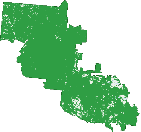
Green: 10 m cells where trees dominate, satellite 2021. Blue: water. The line is the suburb boundary.
| Canopy share, 1 m canopy height map, 2020 | 47.8% |
|---|---|
| Land with trees, 10 m satellite map, 2021 | 93.0% |
Demographics
Unemployment 5.4% · Labour-force participation 50.6%
Population by age in Cooktown
| 0-4 | 152 |
|---|---|
| 5-14 | 379 |
| 15-19 | 152 |
| 20-24 | 108 |
| 25-34 | 261 |
| 35-44 | 331 |
| 45-54 | 376 |
| 55-64 | 439 |
| 65-74 | 367 |
| 75-84 | 172 |
| 85+ | 14 |
Dwelling types in Cooktown
| House | 842 |
|---|---|
| Townhouse | 82 |
| Apartment | 7 |
| Other | 47 |
Households by weekly income in Cooktown
| <$650 | 230 |
|---|---|
| $650-1,499 | 285 |
| $1,500-2,999 | 244 |
| $3,000+ | 116 |
Top ancestries in Cooktown
| Australian | 931 |
|---|---|
| English | 855 |
| Aboriginal | 420 |
| Ancestry NS | 418 |
| Irish | 267 |
| Other | 225 |
Housing tenure in Cooktown
| Owned | 336 |
|---|---|
| Mortgage | 209 |
| Rented | 352 |
| Other | 46 |
Cars per household in Cooktown
| 0 | 70 |
|---|---|
| 1 | 389 |
| 2 | 323 |
| 3 | 114 |
| 4+ | 49 |
Commute to work in Cooktown
| Car | 727 |
|---|---|
| Train | 0 |
| Bus | 3 |
| Tram/ferry | 0 |
| Walked | 88 |
| Bicycle | 5 |
| Home | 87 |
Top countries of birth in Cooktown
| New Zealand | 68 |
|---|---|
| England | 66 |
| Philippines | 19 |
| Germany | 17 |
| South Africa | 16 |
| Papua New Guinea | 15 |
Languages used at home in Cooktown
| Australian Indigenous | 151 |
|---|---|
| German | 17 |
| French | 8 |
| Thai | 7 |
| Malayalam | 6 |
| Spanish | 6 |
Birds & Wildlife Nearby
67,412 bird observations recorded near Cooktown — most often seen:
- Bar-shouldered Dove (5,644)
- Yellow Oriole (5,122)
- Rainbow Lorikeet (4,300)
- Yellow-spotted Honeyeater (4,065)
- Australasian Figbird (3,843)
- Mistletoebird (3,563)
- Spangled Drongo (2,991)
- Varied Triller (2,896)
- Helmeted Friarbird (2,580)
- Hornbill Helmeted Friarbird (2,416)
- Rainbow Bee-eater (2,152)
- White-bellied Cuckoo-shrike (2,059)
- Comb-crested Jacana (2,023)
Show all 30 birds recorded near Cooktown
- Dusky Honeyeater (1,978)
- Masked Lapwing (1,830)
- Black Butcherbird (1,709)
- White-throated Honeyeater (1,674)
- Torresian Imperial-pigeon (1,636)
- Green Pygmy-goose (1,560)
- Red-winged Parrot (1,440)
- Australian Brush-turkey (1,360)
- Brown-backed Honeyeater (1,309)
- Magpie Goose (1,281)
- Shining Flycatcher (1,265)
- Great Egret (1,178)
- Welcome Swallow (1,162)
- Silver Gull (1,150)
- Crested Tern (1,097)
- Sulphur-crested Cockatoo (1,070)
- Large-billed Gerygone (1,059)
Sightings reported by observers, not a survey, so the counts show what people record rather than what lives here. Source: Atlas of Living Australia.
Nearby Suburbs
The closest suburbs to Cooktown:
- Hope Vale (23.8 km)
- Rossville (30.4 km)
- Bloomfield (51.1 km)
- Wujal Wujal (53.8 km)
- Degarra (54 km)
- Lakeland (61.9 km)
Embed this suburb
Add this free Cooktown stat card to your own site — just copy the code:
Preview:
Cite this page
Quoting these figures? Copy the credit line:
Keep an eye on Cooktown
One email when this data meaningfully changes — new census figures, prices, rankings. No spam, unsubscribe anytime.
Streets
- Adelaide Street (37)
- Alexandra Avenue (1)
- Amos Street (23)
- Ann Street (27)
- Annan Road (3)
- Armbrust Street (5)
- Asmuss Street (2)
- Baird Road (12)
- Banks Close (3)
- Banks Street (6)
- Barramundi Boulevard (26)
- Barretts Creek Road (7)
- Bauhinia Street (7)
- Boundary Street (68)
- Bradbury Street (15)
- Brandt Close (6)
- Brown Street (2)
- Buhmann Street (16)
- Burkitt Street (6)
- Cameron Creek Road (3)
- Chace Close (7)
- Charles Street (26)
- Charlotte Street (167)
- Clay Close (8)
- Clerk Street (5)
- Cooktown Developmental Road (1)
- Cycad Close (8)
- Emily Street (4)
- Endeavour Valley Road (143)
- Endeavour Valley Road N (1)
- Esk Valley Road (3)
- Ferrari Street (1)
- Flaggy Road (5)
- Flinders Street (27)
- Furneaux Street (51)
- Gampe Drive (1)
- Garden Street (70)
- Green Street (24)
- Gum Tree Close (9)
- Guzsely Road (6)
- Hagarty Close (6)
- Hannam Street (6)
- Harrigan Street (7)
- Harry Heaths Close (13)
- Helen Street (92)
- Hill Street (2)
- Hip On Street (3)
- Hogg Street (17)
- Holzapfel Road (1)
- Hope Street (172)
- Howard Street (66)
- Hutchinson Street (13)
- Ida Street (28)
- Idress Drive (8)
- Ironwood Avenue (12)
- Irwin Street (8)
- Jensens Crossing Road (11)
- John Street (50)
- Keable Street (2)
- Kellehaven Road (7)
- Kellerhaven Road (7)
- Kerr Street (21)
- Kimberley Street (26)
- Knight Lane (1)
- Lee Road (2)
- Mac Millan Street (1)
- Macmillan Street (1)
- Mangrove Street (8)
- Mason Street (26)
- May Street (94)
- Melaleuca Street (8)
- Milman Street (3)
- Minke Road (2)
- Morris Drive (2)
- Mount Amos Road (10)
- Mt Amos Road (4)
- Mulligan Highway (14)
- Murdoch Road (2)
- Neill Close (5)
- Newman Street (26)
- Oaky Creek Road (15)
- Old Dairy Road (1)
- Palmer Road (1)
- Pandamus Street (1)
- Parkinson Street (14)
- Pascoe Street (4)
- Pebble Close (9)
- Percy Road (2)
- Poison Creek Road (14)
- Police Camp Road (6)
- Power Street (18)
- Pryde Street (30)
- Quarantine Bay Esplanade (11)
- Quarantine Bay Road (24)
- Racecourse Road (37)
- Railway Avenue (39)
- Railway Avenue W (19)
- Rainforest Street (10)
- Ratcliffe Road (1)
- Reid Street (2)
- Roberts Street (3)
- Ronnie Street (1)
- Ryder Road (3)
- Saunder Street (6)
- Savage Street (31)
- Schwartz Street (10)
- Seagren Street (14)
- Shambrook Road (1)
- Sienna Access (3)
- Slaughter Yard Road (31)
- Slaughteryard Road (1)
- Smoko Lane (4)
- Solander Road (4)
- Starke Street (44)
- The Esplanade (18)
- Unit Street (4)
- Walker Street (57)
- Walsh Close (10)
- Wawu Lane (39)
- Webber Esplanade (27)
- Wilkinson Street (10)
- Wilton Access Road (18)