Clayfield QLD 4011
7,620 addresses · 112 streets
Brisbane Electorate › Brisbane LGA › Clayfield · 6 km from Brisbane
📦 Thinking of moving here? Read the Clayfield moving guide

Living Here
Clayfield is a suburb of Queensland, home to about 10,897 people, with a median age of 37. The typical household earns around $1,948 a week, with median rent near $350 a week. Most homes are apartments. About 55% of households own their home and 43% rent. Most workers drive to work. Common community backgrounds include English, Australian, Irish. On the ABS socio-economic scale it sits in decile 10 of 10 nationally — a relatively advantaged area.
Over time — Census 2001 → 2021
Dashed line: district figures for the Clayfield statistical area (SA2), the smallest area the ABS published before 2011. Solid line: Clayfield itself.
Getting Around & Local Services
1 beach
24 hospitals
- Nundah Community Health Centre
- Rosemount Hospital
- Royal Brisbane and Women’s Hospital
- St Vincent's Private Hospital Northside
- The Prince Charles Hospital
- Alderley Child Health
- St Andrews War Memorial Private Hospital
- Brisbane Private Hospital
- Evolve Therapeutic Services
- Saint Vincent's Private Hospital Brisbane
17 childcare & kindergartens
1 butcher
Getting around. Train station: Clayfield, 400 m east · Bus interchange: Toombul Shopping Centre interchange, 1.4 km north-east · Ferry wharf: Bretts Wharf Ferry Terminal, 2.5 km south-east · Airport: Brisbane Airport, 8 km north-east.
Socio-economic Standing
Deciles from 1 (lowest) to 10 (highest), against all Australian suburbs. The overall figure weighs advantage and disadvantage together; economic resources counts income and housing, and education & jobs counts qualifications and occupation. They often differ. Source: ABS SEIFA 2021.
Tree cover
🌳 Tree canopy: 13.7% share of land under canopy · satellite map, 2020
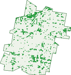
Green: 10 m cells where trees dominate, satellite 2021. Blue: water. The line is the suburb boundary.
| Canopy share, 1 m canopy height map, 2020 | 13.7% |
|---|---|
| Land with trees, 10 m satellite map, 2021 | 6.2% |
Demographics
Unemployment 4.4% · Labour-force participation 72%
Population by age in Clayfield
| 0-4 | 528 |
|---|---|
| 5-14 | 1,144 |
| 15-19 | 589 |
| 20-24 | 848 |
| 25-34 | 1,931 |
| 35-44 | 1,632 |
| 45-54 | 1,525 |
| 55-64 | 1,232 |
| 65-74 | 819 |
| 75-84 | 469 |
| 85+ | 182 |
Dwelling types in Clayfield
| House | 1,785 |
|---|---|
| Townhouse | 499 |
| Apartment | 2,425 |
| Other | 11 |
Households by weekly income in Clayfield
| <$650 | 552 |
|---|---|
| $650-1,499 | 1,181 |
| $1,500-2,999 | 1,400 |
| $3,000+ | 1,370 |
Top ancestries in Clayfield
| English | 4,160 |
|---|---|
| Australian | 3,231 |
| Irish | 1,836 |
| Other | 1,600 |
| Scottish | 1,414 |
| German | 649 |
Housing tenure in Clayfield
| Owned | 1,151 |
|---|---|
| Mortgage | 1,444 |
| Rented | 2,029 |
| Other | 57 |
Cars per household in Clayfield
| 0 | 420 |
|---|---|
| 1 | 2,324 |
| 2 | 1,432 |
| 3 | 324 |
| 4+ | 175 |
Commute to work in Clayfield
| Car | 3,001 |
|---|---|
| Train | 439 |
| Bus | 200 |
| Tram/ferry | 12 |
| Walked | 121 |
| Bicycle | 64 |
| Home | 1,501 |
Top countries of birth in Clayfield
| England | 377 |
|---|---|
| New Zealand | 335 |
| Nepal | 320 |
| India | 313 |
| Philippines | 120 |
| South Africa | 96 |
Languages used at home in Clayfield
| Nepali | 333 |
|---|---|
| Mandarin | 133 |
| Spanish | 105 |
| Hindi | 84 |
| Cantonese | 70 |
| Punjabi | 70 |
Birds & Wildlife Nearby
107,834 bird observations recorded near Clayfield — most often seen:
- Torresian Crow (7,479)
- Australian White Ibis (6,338)
- Rainbow Lorikeet (6,221)
- Welcome Swallow (5,833)
- Noisy Miner (5,507)
- Magpie-lark (5,497)
- Willie Wagtail (4,739)
- Australian Magpie (4,051)
- Masked Lapwing (3,897)
- Rock Dove (3,628)
- Pacific Black Duck (3,590)
- Superb Fairy-wren (3,466)
- Brown Honeyeater (3,216)
Show all 30 birds recorded near Clayfield
- Pied Butcherbird (3,059)
- Grey Butcherbird (2,932)
- Australian Pelican (2,889)
- Australasian Figbird (2,878)
- White-faced Heron (2,795)
- Little Black Cormorant (2,743)
- Little Pied Cormorant (2,663)
- Tawny Grassbird (2,657)
- Black-faced Cuckoo-shrike (2,639)
- Dusky Moorhen (2,547)
- Laughing Kookaburra (2,538)
- Great Egret (2,480)
- Common Myna (2,457)
- Scaly-breasted Lorikeet (2,413)
- Pied Currawong (2,258)
- Chestnut Teal (2,243)
- Spotted Turtle-dove (2,181)
Sightings reported by observers, not a survey, so the counts show what people record rather than what lives here. Source: Atlas of Living Australia.
Nearby Suburbs
The closest suburbs to Clayfield:
Embed this suburb
Add this free Clayfield stat card to your own site — just copy the code:
Preview:
Cite this page
Quoting these figures? Copy the credit line:
Keep an eye on Clayfield
One email when this data meaningfully changes — new census figures, prices, rankings. No spam, unsubscribe anytime.
Streets
- Adelaide Street (74)
- Adelaide Street E (44)
- Alexandra Road (75)
- Alma Road (200)
- Angle Street (1)
- Apex Street (8)
- Armagh Street (59)
- Balmain Street (1)
- Barlow Street (166)
- Bartley Street (4)
- Batman Street (30)
- Bayview Terrace (136)
- Beaufort Lane (8)
- Bellevue Terrace (146)
- Bonney Avenue (512)
- Boston Street (41)
- Botany Street (44)
- Bourne Street (35)
- Brentwood Street (12)
- Brooke Street (11)
- Burrell Street (21)
- Butler Street (1)
- Childs Street (67)
- Christian Street (96)
- Clarkson Street (6)
- Collins Street (129)
- Cooma Street (20)
- Craven Street (12)
- Creswick Street (30)
- Crombie Street (26)
- Denham Street (42)
- Drane Street (64)
- Dublin Street (38)
- Eliza Street (140)
- Elliott Street (97)
- Enderley Avenue (20)
- Enderley Road (42)
- Fitzroy Street (23)
- Florence Street (28)
- Ford Street (44)
- Franz Road (112)
- Garnet Street (36)
- Gellibrand Street (199)
- Gregory Street (66)
- Haig Street (73)
- Henry Street (1)
- Highclere Street (22)
- Hockings Street (54)
- Howie Street (43)
- Hunter Lane (3)
- Hutton Street (32)
- Jackson Street (80)
- Jolly Street (25)
- Junction Road (407)
- Kalinga Street (32)
- Kedron Street (2)
- Keith Street (20)
- Kemble Street (22)
- Lewis Street (52)
- Lisson Grove (9)
- Liverpool Road (59)
- Lodge Road (1)
- London Road (131)
- Lukin Street (26)
- Mabel Street (6)
- Marsden Street (49)
- Maxwell Street (14)
- Mcgregor Street (38)
- Miles Street (131)
- Milman Street (34)
- Milne Street (36)
- Montpelier Street (138)
- Morrison Road (15)
- Nellie Street (8)
- Noble Street (214)
- Norman Parade (121)
- Oriel Road (143)
- Park Avenue (54)
- Phelan Street (39)
- Queens Road (54)
- Railway Parade (68)
- Rees Avenue (47)
- Reeve Street (174)
- Reid Avenue (4)
- Riverton Street (193)
- Roseby Avenue (53)
- Sandgate Road (747)
- Sandringham Street (7)
- Sefton Avenue (30)
- Sefton Road (25)
- Shirley Street (13)
- Stafford Street (7)
- Stewart Street (4)
- Stopford Street (1)
- Stuckey Road (133)
- Sydney Street (52)
- Tarranalma Avenue (7)
- Thomas Street (29)
- Union Street (42)
- Victoria Parade (46)
- Victoria Street (41)
- Vine Street (78)
- Wagner Road (242)
- Waratah Street (10)
- Wellington Street (96)
- Widdop Street (28)
- Wildman Lane (1)
- Wildman Street (9)
- Winifred Street (37)
- Wolseley Street (65)
- Wongara Street (174)
- Woombye Street (3)