Bundamba QLD 4304
3,847 addresses · 141 streets
Blair Electorate › Ipswich LGA › Bundamba · 26 km from Brisbane
📦 Thinking of moving here? Read the Bundamba moving guide

Living Here
Bundamba is a suburb of Queensland, home to about 6,542 people, with a median age of 35. The typical household earns around $1,383 a week, with median rent near $300 a week. Most homes are houses. About 57% of households own their home and 42% rent. Most workers drive to work. Common community backgrounds include English, Australian, Scottish. On the ABS socio-economic scale it sits in decile 2 of 10 nationally — a more disadvantaged area.
Over time — Census 2001 → 2021
Dashed line: district figures for the Bundamba statistical area (SA2), the smallest area the ABS published before 2011. Solid line: Bundamba itself.
Getting Around & Local Services
3 supermarkets
3 Catholic churches
1 pharmacy
5 optometrists
1 vet
3 childcare & kindergartens
2 libraries
1 post office
4 gyms & sports centres
1 butcher
4 hardware stores
1 hairdresser
1 electrician
3 carpenters
Getting around. Train station: Bundamba, 750 m west · Railway halt: Bundamba Racecourse, 1.4 km south-west · Ferry wharf: Riverview, 4.5 km east · Airport: Brisbane Airport, 39.6 km north-east.
Socio-economic Standing
Deciles from 1 (lowest) to 10 (highest), against all Australian suburbs. The overall figure weighs advantage and disadvantage together; economic resources counts income and housing, and education & jobs counts qualifications and occupation. They often differ. Source: ABS SEIFA 2021.
Tree cover
🌳 Tree canopy: 13.7% share of land under canopy · satellite map, 2020
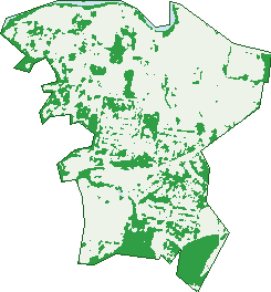
Green: 10 m cells where trees dominate, satellite 2021. Blue: water. The line is the suburb boundary.
| Canopy share, 1 m canopy height map, 2020 | 13.7% |
|---|---|
| Land with trees, 10 m satellite map, 2021 | 26.7% |
Demographics
Unemployment 7.8% · Labour-force participation 58.8%
Population by age in Bundamba
| 0-4 | 404 |
|---|---|
| 5-14 | 921 |
| 15-19 | 392 |
| 20-24 | 435 |
| 25-34 | 1,041 |
| 35-44 | 859 |
| 45-54 | 806 |
| 55-64 | 739 |
| 65-74 | 571 |
| 75-84 | 261 |
| 85+ | 95 |
Dwelling types in Bundamba
| House | 2,037 |
|---|---|
| Townhouse | 349 |
| Apartment | 44 |
| Other | 0 |
Households by weekly income in Bundamba
| <$650 | 408 |
|---|---|
| $650-1,499 | 835 |
| $1,500-2,999 | 789 |
| $3,000+ | 245 |
Top ancestries in Bundamba
| English | 2,488 |
|---|---|
| Australian | 2,421 |
| Scottish | 664 |
| Irish | 648 |
| Other | 515 |
| Ancestry NS | 507 |
Housing tenure in Bundamba
| Owned | 586 |
|---|---|
| Mortgage | 800 |
| Rented | 1,011 |
| Other | 16 |
Cars per household in Bundamba
| 0 | 158 |
|---|---|
| 1 | 928 |
| 2 | 853 |
| 3 | 305 |
| 4+ | 163 |
Commute to work in Bundamba
| Car | 1,983 |
|---|---|
| Train | 79 |
| Bus | 9 |
| Tram/ferry | 0 |
| Walked | 24 |
| Bicycle | 4 |
| Home | 249 |
Top countries of birth in Bundamba
| New Zealand | 256 |
|---|---|
| England | 148 |
| Philippines | 64 |
| Samoa | 61 |
| Vietnam | 32 |
| China | 28 |
Languages used at home in Bundamba
| Samoan | 119 |
|---|---|
| Mandarin | 35 |
| Vietnamese | 28 |
| Hindi | 23 |
| Cantonese | 21 |
| Spanish | 20 |
Birds & Wildlife Nearby
23,633 bird observations recorded near Bundamba — most often seen:
- Torresian Crow (1,433)
- Noisy Miner (1,287)
- Rainbow Lorikeet (1,255)
- Australian Magpie (1,097)
- Scaly-breasted Lorikeet (964)
- Australian Wood Duck (947)
- Welcome Swallow (890)
- Dusky Moorhen (886)
- Pacific Black Duck (883)
- Laughing Kookaburra (839)
- Masked Lapwing (827)
- Sulphur-crested Cockatoo (809)
- Pied Butcherbird (802)
Show all 30 birds recorded near Bundamba
- Striated Pardalote (789)
- Galah (787)
- Magpie-lark (765)
- Brown Honeyeater (716)
- Crested Pigeon (708)
- Superb Fairy-wren (705)
- Willie Wagtail (684)
- Blue-faced Honeyeater (647)
- Black-faced Cuckoo-shrike (632)
- Grey Butcherbird (595)
- Pale-headed Rosella (560)
- Little Corella (559)
- Australasian Purple Swamphen (536)
- Little Pied Cormorant (520)
- Red-backed Fairy-wren (509)
- Australasian Figbird (506)
- Australian White Ibis (496)
Sightings reported by observers, not a survey, so the counts show what people record rather than what lives here. Source: Atlas of Living Australia.
Nearby Suburbs
The closest suburbs to Bundamba:
- Ebbw Vale (1.2 km)
- North Booval (2 km)
- New Chum (2.2 km)
- Booval (2.2 km)
- Blackstone (2.3 km)
- Dinmore (2.3 km)
- Silkstone (2.9 km)
- Moores Pocket (3.3 km)
Embed this suburb
Add this free Bundamba stat card to your own site — just copy the code:
Preview:
Cite this page
Quoting these figures? Copy the credit line:
Keep an eye on Bundamba
One email when this data meaningfully changes — new census figures, prices, rankings. No spam, unsubscribe anytime.
Streets
- Aberdeen Street (26)
- Access Place (8)
- Adam Street (13)
- Agnes Street (26)
- Andrew Street (46)
- Ann Street (8)
- Ashburn Road (15)
- Banbury Close (16)
- Barclay Street (64)
- Belleglade Avenue (37)
- Bellhaven Drive (16)
- Bergins Hill Road (28)
- Bird Street (53)
- Blackheath Street (7)
- Bognuda Street (74)
- Bonnie Dundee Court (9)
- Bould Court (14)
- Boundary Street (31)
- Boyce Street (7)
- Braeburn Way (2)
- Braeridge Drive (40)
- Braeside Road (85)
- Brentwood Drive (143)
- Brisbane Road (101)
- Brolga Court (8)
- Bryant Street (13)
- Burgoyne Street (45)
- Byrne Street (46)
- Cain Court (15)
- Carberry Street (11)
- Carlisle Court (9)
- Charles Street (12)
- Cleary Street (13)
- Coal Street (15)
- Cooneana Street (28)
- Cooneanna Street (2)
- Cornish Street (13)
- Craies Street (44)
- Creek Street (79)
- Cullen Street (54)
- Currawong Street (18)
- Davis Street (3)
- Denman Drive (16)
- Donro Court (5)
- Dorsey Crescent (29)
- Drysdale Crescent (42)
- Duce Street (11)
- Eclipse Court (9)
- Egerton Street (10)
- Elizabeth Street (7)
- Elmore Court (11)
- Elms Street (33)
- Emma Street (1)
- Enson Street (20)
- Foxton Street (22)
- Gill Court (9)
- Gliderway Street (22)
- Gorrick Court (4)
- Graham Street (4)
- Granville Crescent (15)
- Habben Court (30)
- Hanlon Street (16)
- Hanran Court (12)
- Harold Street (70)
- Hart Street (13)
- Hawkins Crescent (37)
- Herbert Street (14)
- High Street (44)
- Highfield Street (29)
- Hind Court (5)
- Hoepner Road (14)
- Hoffmann Way (42)
- Horton Street (33)
- Hume Drive (76)
- Innes Crescent (72)
- James Street (15)
- Jeffrey Street (3)
- Jet Place (1)
- John Street (23)
- Jones Street (16)
- Keith Street (29)
- Kingfisher Court (12)
- Kirk Street (15)
- Lacy Place (7)
- Lane Street (2)
- Law Street (39)
- Lindsay Street (134)
- Littleford Circuit (73)
- Livermore Lane (10)
- Lorrikeet Street (36)
- Lower Mccormack Street (24)
- Macartney Street (1)
- Mafeking Street (1)
- Mary Street (65)
- Masterpanel Lane (4)
- Maud Lane (2)
- Mcconnell Street (2)
- Mckenzie Street (30)
- Mcmahon Street (20)
- Mining Street (67)
- Morris Street (35)
- Naomai Street (56)
- Nelson Street (57)
- O'malley Street (12)
- Oak Street (10)
- Ogilvie Street (22)
- Paice Street (15)
- Peacock Drive (11)
- Perrett Street (14)
- Pitceathly Street (14)
- Portley Street (14)
- River Road (329)
- Ronald Street (17)
- Rule Drive (22)
- Rush Court (9)
- Shanks Court (12)
- Short Street (7)
- Stathis Place (16)
- Stubbin Street (36)
- Sugars Place (8)
- T L Cooney Avenue (1)
- Taylor Street (32)
- Thompson Street (40)
- Tibbits Street (44)
- Upper Mccormack Street (15)
- Vale Street (22)
- Videroni Street (33)
- Wade Street (40)
- Wall Street (54)
- Warner Road (1)
- Warrego Highway (2)
- Watkins Street (2)
- Webb Street (4)
- Wellen Street (29)
- Weymouth Street (26)
- White Street (22)
- William Street (35)
- Wise Street (5)
- Wood Street (5)
- Wren Court (6)
- Yarrow Court (8)