Browns Plains QLD 4118
4,079 addresses · 108 streets
Rankin Electorate › Logan LGA › Browns Plains · 21 km from Brisbane
📦 Thinking of moving here? Read the Browns Plains moving guide

Living Here
Browns Plains is a suburb of Queensland, home to about 6,632 people, with a median age of 34. The typical household earns around $1,390 a week, with median rent near $350 a week. Most homes are houses. About 51% of households own their home and 48% rent. Most workers drive to work. Common community backgrounds include English, Australian, Ancestry NS. On the ABS socio-economic scale it sits in decile 1 of 10 nationally — a more disadvantaged area.
Over time — Census 2001 → 2021
Dashed line: district figures for the Browns Plains statistical area (SA2), the smallest area the ABS published before 2011. Solid line: Browns Plains itself.
Getting Around & Local Services
18 schools
1 dentist
4 childcare & kindergartens
1 post office
2 golf clubs
1 bakery
3 hardware stores
1 hairdresser
1 beauty salon
1 mechanic
3 electricians
1 plumber
2 places to stay
Getting around. Train station: Trinder Park, 5.3 km north-east · Bus interchange: Clarks Logan City Bus Service - Bus Depot, 7 km east · Airport: Brisbane Airport, 32 km north.
Socio-economic Standing
Deciles from 1 (lowest) to 10 (highest), against all Australian suburbs. The overall figure weighs advantage and disadvantage together; economic resources counts income and housing, and education & jobs counts qualifications and occupation. They often differ. Source: ABS SEIFA 2021.
Tree cover
🌳 Tree canopy: 30.6% share of land under canopy · satellite map, 2020
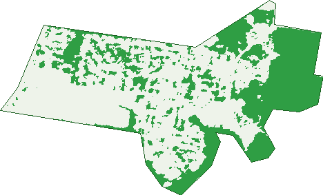
Green: 10 m cells where trees dominate, satellite 2021. Blue: water. The line is the suburb boundary.
| Canopy share, 1 m canopy height map, 2020 | 30.6% |
|---|---|
| Land with trees, 10 m satellite map, 2021 | 37.8% |
Demographics
Unemployment 9.3% · Labour-force participation 56.4%
Population by age in Browns Plains
| 0-4 | 475 |
|---|---|
| 5-14 | 991 |
| 15-19 | 448 |
| 20-24 | 478 |
| 25-34 | 1,030 |
| 35-44 | 932 |
| 45-54 | 818 |
| 55-64 | 685 |
| 65-74 | 487 |
| 75-84 | 202 |
| 85+ | 89 |
Dwelling types in Browns Plains
| House | 1,691 |
|---|---|
| Townhouse | 392 |
| Apartment | 83 |
| Other | 0 |
Households by weekly income in Browns Plains
| <$650 | 325 |
|---|---|
| $650-1,499 | 796 |
| $1,500-2,999 | 725 |
| $3,000+ | 195 |
Top ancestries in Browns Plains
| English | 1,960 |
|---|---|
| Australian | 1,804 |
| Other | 1,351 |
| Ancestry NS | 703 |
| Irish | 404 |
| Scottish | 377 |
Housing tenure in Browns Plains
| Owned | 417 |
|---|---|
| Mortgage | 674 |
| Rented | 1,032 |
| Other | 18 |
Cars per household in Browns Plains
| 0 | 119 |
|---|---|
| 1 | 823 |
| 2 | 802 |
| 3 | 265 |
| 4+ | 132 |
Commute to work in Browns Plains
| Car | 1,982 |
|---|---|
| Train | 10 |
| Bus | 63 |
| Tram/ferry | 0 |
| Walked | 25 |
| Bicycle | 4 |
| Home | 194 |
Top countries of birth in Browns Plains
| New Zealand | 473 |
|---|---|
| China | 134 |
| England | 128 |
| India | 120 |
| Philippines | 115 |
| Taiwan | 68 |
Languages used at home in Browns Plains
| Mandarin | 217 |
|---|---|
| Samoan | 94 |
| Hindi | 87 |
| Urdu | 73 |
| Punjabi | 68 |
| Vietnamese | 61 |
Birds & Wildlife Nearby
26,794 bird observations recorded near Browns Plains — most often seen:
- Torresian Crow (1,610)
- Rainbow Lorikeet (1,372)
- Australian White Ibis (1,312)
- Dusky Moorhen (1,273)
- Australian Magpie (1,254)
- Noisy Miner (1,253)
- Pacific Black Duck (1,118)
- Laughing Kookaburra (1,042)
- Striated Pardalote (912)
- Noisy Friarbird (881)
- Australasian Purple Swamphen (880)
- Yellow-faced Honeyeater (876)
- Black-faced Cuckoo-shrike (830)
Show all 30 birds recorded near Browns Plains
- Australasian Darter (819)
- Brown Honeyeater (785)
- Grey Butcherbird (775)
- Magpie-lark (771)
- Australian Pelican (760)
- Little Black Cormorant (747)
- Australian Wood Duck (744)
- Sulphur-crested Cockatoo (741)
- Common Myna (732)
- Little Pied Cormorant (716)
- Pied Butcherbird (709)
- Pied Currawong (703)
- Grey Shrike-thrush (649)
- Eastern Rainbow Lorikeet (639)
- Spotted Turtle-dove (635)
- Scaly-breasted Lorikeet (630)
- Red-backed Fairy-wren (626)
Sightings reported by observers, not a survey, so the counts show what people record rather than what lives here. Source: Atlas of Living Australia.
Nearby Suburbs
The closest suburbs to Browns Plains:
- Drewvale (1.4 km)
- Regents Park (2.2 km)
- Heritage Park (2.5 km)
- Berrinba (2.8 km)
- Hillcrest (3 km)
- Parkinson (3.7 km)
- Calamvale (4.3 km)
- Marsden (4.4 km)
Embed this suburb
Add this free Browns Plains stat card to your own site — just copy the code:
Preview:
Cite this page
Quoting these figures? Copy the credit line:
Keep an eye on Browns Plains
One email when this data meaningfully changes — new census figures, prices, rankings. No spam, unsubscribe anytime.
Streets
- Aaron Circuit (52)
- Acacia Street (20)
- Academy Street (41)
- Adam Street (37)
- Aidan Street (9)
- Alrak Avenue (18)
- Ammons Street (32)
- Anook Avenue (14)
- Bank Street (16)
- Banksia Street (25)
- Basie Court (17)
- Begonia Street (130)
- Ben Street (7)
- Berkley Drive (30)
- Berkley Drive N (11)
- Box Street (18)
- Brett Avenue (27)
- Browns Plains Road (486)
- Brubeck Court (18)
- Campden Street (34)
- Cassia Street (23)
- Castle Street (17)
- Chloe Street (5)
- Claussen Street (357)
- Commerce Drive (59)
- Cooper Court (7)
- Coronado Street (3)
- Coyle Court (9)
- Curzon Street (31)
- Dante Crescent (7)
- Dover Court (8)
- Downing Street (8)
- Dunbar Street (6)
- Eady Street (7)
- Eastern Road (128)
- Ellington Street (33)
- Elm Court (13)
- Enterprise Way (16)
- Erin Drive (40)
- Fern Street (9)
- Fleet Street (137)
- Forestglen Crescent (61)
- Furzer Street (71)
- Glen Street (13)
- Glendale Crescent (31)
- Grand Plaza Drive (107)
- Greenfern Drive (2)
- Halfmoon Street (25)
- Hamstead Court (6)
- Harmony Court (9)
- Highcrest Drive (53)
- Hoffman Court (7)
- Holmes Court (16)
- Hughes Street (34)
- Ivor Street (3)
- Janita Drive (34)
- Jordin Street (40)
- Joseph Court (17)
- Kensington Street (24)
- Lena Street (36)
- Leonard Street (6)
- Lorna Street (32)
- Macquarie Way (62)
- Mayfair Drive (51)
- Melbury Street (43)
- Morrant Court (11)
- Mount Lindesay Highway (125)
- Mount Street (6)
- Myola Street (123)
- Neale Court (14)
- Oak Avenue (26)
- Oakdale Street (41)
- Parkland Avenue (40)
- Piccadilly Court (5)
- Pine Crescent (11)
- Ranchwood Avenue (50)
- Rooney Street (6)
- Saint Jude Court (52)
- Sandy Close (48)
- Saratoga Street (37)
- Saville Court (11)
- Savoy Court (10)
- Scenic Avenue (13)
- Scrubby Creek Road (13)
- Serena Street (17)
- Sheffield Court (38)
- Sherwood Drive (52)
- Straight Drive (36)
- Sunset Street (19)
- Susan Street (22)
- Sussex Street (13)
- Sutton Court (8)
- Tiffany Street (2)
- Timbertop Avenue (27)
- Trebeck Street (40)
- Vanice Court (7)
- Victoria Court (19)
- Vine Loop (7)
- Vivi Street (23)
- Waller Road (23)
- Waterman Place (33)
- Webber Drive (10)
- Wembley Road (123)
- Whitehall Street (16)
- Woodland Crescent (23)
- Woodview Street (34)
- Yancey Street (59)
- Zorina Street (38)