Brighton QLD 4017
4,640 addresses · 132 streets
Lilley Electorate › Brisbane LGA › Brighton · 19 km from Brisbane
📦 Thinking of moving here? Read the Brighton moving guide

Living Here
Brighton is a suburb of Queensland, home to about 9,664 people, with a median age of 42. The typical household earns around $1,981 a week, with median rent near $400 a week. Most homes are houses. About 79% of households own their home and 21% rent. Most workers drive to work. Common community backgrounds include English, Australian, Irish. On the ABS socio-economic scale it sits in decile 8 of 10 nationally — a relatively advantaged area.
Over time — Census 2001 → 2021
Dashed line: district figures for the Brighton (Qld) statistical area (SA2), the smallest area the ABS published before 2011. Solid line: Brighton itself.
Getting Around & Local Services
3 supermarkets
2 doctors & medical clinics
2 dentists
1 physiotherapist
2 optometrists
1 playground
2 dog parks
1 butcher
2 hardware stores
1 beauty salon
1 mechanic
1 plumber
1 place to stay
Getting around. Train station: Sandgate, 2.9 km south-east · Bus interchange: Strathpine bus station, 6.3 km west · Airport: Brisbane Airport, 11.1 km south-east.
Socio-economic Standing
Deciles from 1 (lowest) to 10 (highest), against all Australian suburbs. The overall figure weighs advantage and disadvantage together; economic resources counts income and housing, and education & jobs counts qualifications and occupation. They often differ. Source: ABS SEIFA 2021.
Tree cover
🌳 Tree canopy: 23% share of land under canopy · satellite map, 2020
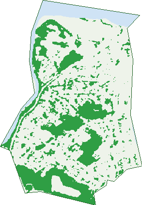
Green: 10 m cells where trees dominate, satellite 2021. Blue: water. The line is the suburb boundary.
| Canopy share, 1 m canopy height map, 2020 | 23.0% |
|---|---|
| Land with trees, 10 m satellite map, 2021 | 27.2% |
Demographics
Unemployment 3.8% · Labour-force participation 66%
Population by age in Brighton
| 0-4 | 565 |
|---|---|
| 5-14 | 1,363 |
| 15-19 | 551 |
| 20-24 | 399 |
| 25-34 | 880 |
| 35-44 | 1,429 |
| 45-54 | 1,581 |
| 55-64 | 1,324 |
| 65-74 | 935 |
| 75-84 | 484 |
| 85+ | 165 |
Dwelling types in Brighton
| House | 3,308 |
|---|---|
| Townhouse | 209 |
| Apartment | 41 |
| Other | 112 |
Households by weekly income in Brighton
| <$650 | 534 |
|---|---|
| $650-1,499 | 817 |
| $1,500-2,999 | 1,078 |
| $3,000+ | 979 |
Top ancestries in Brighton
| English | 4,390 |
|---|---|
| Australian | 3,623 |
| Irish | 1,499 |
| Scottish | 1,347 |
| Other | 686 |
| German | 682 |
Housing tenure in Brighton
| Owned | 1,165 |
|---|---|
| Mortgage | 1,617 |
| Rented | 726 |
| Other | 27 |
Cars per household in Brighton
| 0 | 144 |
|---|---|
| 1 | 1,198 |
| 2 | 1,526 |
| 3 | 433 |
| 4+ | 242 |
Commute to work in Brighton
| Car | 2,865 |
|---|---|
| Train | 114 |
| Bus | 33 |
| Tram/ferry | 0 |
| Walked | 43 |
| Bicycle | 33 |
| Home | 944 |
Top countries of birth in Brighton
| England | 550 |
|---|---|
| New Zealand | 369 |
| Scotland | 81 |
| South Africa | 56 |
| Philippines | 53 |
| Germany | 47 |
Languages used at home in Brighton
| German | 41 |
|---|---|
| French | 26 |
| Italian | 26 |
| Tagalog | 23 |
| Cantonese | 21 |
| Mandarin | 19 |
Birds & Wildlife Nearby
247,092 bird observations recorded near Brighton — most often seen:
- Australian White Ibis (15,756)
- Torresian Crow (14,708)
- Noisy Miner (14,085)
- Welcome Swallow (12,364)
- Rainbow Lorikeet (12,093)
- Australian Magpie (10,593)
- Magpie-lark (9,701)
- Pacific Black Duck (9,287)
- Masked Lapwing (8,970)
- Little Black Cormorant (8,887)
- Willie Wagtail (8,740)
- Pied Butcherbird (8,310)
- Little Pied Cormorant (8,161)
Show all 30 birds recorded near Brighton
- Australasian Purple Swamphen (8,105)
- Dusky Moorhen (7,659)
- Silver Gull (7,144)
- Brown Honeyeater (6,874)
- Intermediate Egret (6,696)
- Great Egret (6,579)
- Grey Butcherbird (6,572)
- Laughing Kookaburra (6,255)
- Australasian Figbird (5,968)
- Australian Pelican (5,776)
- Australasian Darter (5,768)
- Crested Pigeon (5,703)
- Australasian Grebe (5,474)
- Black-faced Cuckoo-shrike (5,380)
- White-faced Heron (5,277)
- Sacred Kingfisher (5,250)
- Little Egret (4,957)
Sightings reported by observers, not a survey, so the counts show what people record rather than what lives here. Source: Atlas of Living Australia.
Nearby Suburbs
The closest suburbs to Brighton:
- Sandgate (2.2 km)
- Deagon (3.3 km)
- Bracken Ridge (3.5 km)
- Shorncliffe (3.9 km)
- Bald Hills (4.7 km)
- Griffin (4.7 km)
- Taigum (5.1 km)
- Fitzgibbon (5.4 km)
Embed this suburb
Add this free Brighton stat card to your own site — just copy the code:
Preview:
Cite this page
Quoting these figures? Copy the credit line:
Keep an eye on Brighton
One email when this data meaningfully changes — new census figures, prices, rankings. No spam, unsubscribe anytime.
Streets
- Ambrose Street (5)
- Arundal Street (77)
- Aston Close (10)
- Axholme Street (15)
- Badet Street (14)
- Baldry Street (9)
- Barfoot Street (1)
- Baskerville Street (54)
- Bayview Road (99)
- Beaconsfield Terrace (228)
- Bernard Street (21)
- Best Street (10)
- Binden Street (4)
- Bournewood Street (56)
- Bracken Ridge Road (1)
- Bradfield Street (97)
- Brighton Lane (3)
- Brighton Terrace (57)
- Capel Street (43)
- Celles Street (8)
- Cherry Street (24)
- Claudette Street (17)
- Conn Street (16)
- Corner Street (7)
- Craig Street (58)
- Cremorne Place (17)
- Creton Street (22)
- Debin Street (4)
- Dickson Street (20)
- Douglas Street (31)
- Duke Street (36)
- Dunne Street (92)
- East Avenue (15)
- Easter Street (4)
- Eighteenth Avenue (17)
- Eleventh Avenue (24)
- Elizabeth Place (19)
- Ellora Street (3)
- Ferguson Street (8)
- Fifteenth Avenue (24)
- Flinders Parade (151)
- Florence Street (55)
- Fourteenth Avenue (17)
- Gladstone Street (29)
- Glendavis Street (9)
- Gloucester Street (44)
- Goodenia Place (14)
- Gordon Street (57)
- Greenwood Street (32)
- Greil Street (14)
- Gynther Avenue (51)
- Hall Street (13)
- Hamilton Street (4)
- Herbert Street (55)
- High Street (108)
- Hillier Street (9)
- Holmes Street (120)
- Hornibrook Highway (14)
- Illaroo Street (7)
- Jill Street (19)
- Joyceland Street (20)
- Kenbarry Street (26)
- Kennedy Street (59)
- Kirkhill Street (22)
- Lascelles Street (163)
- Lauren Circuit (27)
- Lebanon Street (41)
- Lloyd Street (27)
- Loncroft Street (24)
- Longstaff Street (29)
- Maclean Street (40)
- Macs Street (10)
- Margaret Close (9)
- Mary Ellen Street (5)
- Massie Street (22)
- Mcmahon Street (11)
- Morcombe Street (34)
- Morgan Street (12)
- Munster Street (5)
- Narrabri Street (9)
- Nathan Street (113)
- Neal Street (28)
- Newport Street (7)
- Nineteenth Avenue (11)
- North Road (135)
- Northcote Street (75)
- Nundah Street (18)
- O'dare Street (24)
- Palina Street (17)
- Paul Street (54)
- Pollard Street (11)
- Pomona Street (19)
- Prince Street (49)
- Princess Street (14)
- Queens Parade (171)
- Range Avenue (14)
- Regency Street (68)
- Rensburg Street (73)
- Romney Street (6)
- Sackett Street (13)
- Sandown Street (19)
- Sandralee Street (21)
- Saul Street (82)
- Seaview Street (45)
- Seventeenth Avenue (56)
- Shaw Close (11)
- Shepherd Street (25)
- Sixteenth Avenue (58)
- Sonya Street (1)
- Speight Street (139)
- Stanley Terrace (12)
- Stubbs Street (18)
- Sunnybrook Street (28)
- Sunwell Street (44)
- Tenth Avenue (7)
- Thirteenth Avenue (20)
- Townsend Street (56)
- Twelfth Avenue (47)
- Twentieth Avenue (25)
- Twenty Fifth Avenue (2)
- Twenty First Avenue (29)
- Twenty Fourth Avenue (2)
- Twenty Second Avenue (25)
- Twenty Third Avenue (50)
- Vancouver Street (8)
- Venice Crescent (6)
- Victoria Street (47)
- Walton Place (17)
- West Avenue (16)
- Whitman Street (42)
- Wickham Street (71)
- Wiltshire Street (4)