Atherton QLD 4883
5,719 addresses · 240 streets
Kennedy Electorate › Tablelands LGA › Atherton · 1374 km from Brisbane
📦 Thinking of moving here? Read the Atherton moving guide

Living Here
Atherton is a suburb of Queensland, home to about 7,724 people, with a median age of 46. The typical household earns around $1,099 a week, with median rent near $280 a week. Most homes are houses. About 60% of households own their home and 38% rent. Most workers drive to work. Common community backgrounds include English, Australian, Irish. On the ABS socio-economic scale it sits in decile 2 of 10 nationally — a more disadvantaged area.
Over time — Census 2001 → 2021
Dashed line: district figures for the Atherton statistical area (SA2), the smallest area the ABS published before 2011. Solid line: Atherton itself.
Getting Around & Local Services
2 supermarkets
1 pharmacy
1 hospital
1 library
1 post office
3 service stations
1 golf club
1 hardware store
1 mechanic
Getting around. Airport: Mareeba Airport, 22.6 km north.
Socio-economic Standing
Deciles from 1 (lowest) to 10 (highest), against all Australian suburbs. The overall figure weighs advantage and disadvantage together; economic resources counts income and housing, and education & jobs counts qualifications and occupation. They often differ. Source: ABS SEIFA 2021.
Tree cover
🌳 Tree canopy: 18.8% share of land under canopy · satellite map, 2020
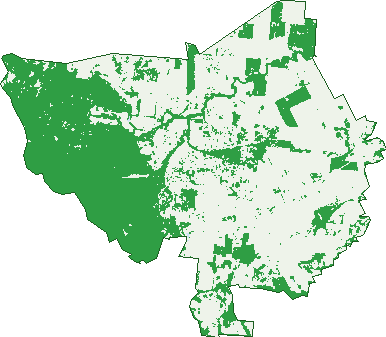
Green: 10 m cells where trees dominate, satellite 2021. Blue: water. The line is the suburb boundary.
| Canopy share, 1 m canopy height map, 2020 | 18.8% |
|---|---|
| Land with trees, 10 m satellite map, 2021 | 42.2% |
Demographics
Unemployment 5% · Labour-force participation 50.5%
Population by age in Atherton
| 0-4 | 347 |
|---|---|
| 5-14 | 960 |
| 15-19 | 473 |
| 20-24 | 353 |
| 25-34 | 893 |
| 35-44 | 734 |
| 45-54 | 923 |
| 55-64 | 948 |
| 65-74 | 1,063 |
| 75-84 | 698 |
| 85+ | 334 |
Dwelling types in Atherton
| House | 2,529 |
|---|---|
| Townhouse | 297 |
| Apartment | 213 |
| Other | 37 |
Households by weekly income in Atherton
| <$650 | 774 |
|---|---|
| $650-1,499 | 980 |
| $1,500-2,999 | 759 |
| $3,000+ | 284 |
Top ancestries in Atherton
| English | 2,884 |
|---|---|
| Australian | 2,809 |
| Irish | 961 |
| Scottish | 804 |
| Ancestry NS | 724 |
| Other | 661 |
Housing tenure in Atherton
| Owned | 1,142 |
|---|---|
| Mortgage | 684 |
| Rented | 1,142 |
| Other | 51 |
Cars per household in Atherton
| 0 | 228 |
|---|---|
| 1 | 1,309 |
| 2 | 1,007 |
| 3 | 314 |
| 4+ | 164 |
Commute to work in Atherton
| Car | 2,203 |
|---|---|
| Train | 0 |
| Bus | 26 |
| Tram/ferry | 3 |
| Walked | 158 |
| Bicycle | 17 |
| Home | 228 |
Top countries of birth in Atherton
| England | 220 |
|---|---|
| New Zealand | 150 |
| Italy | 65 |
| Philippines | 61 |
| Germany | 55 |
| Papua New Guinea | 53 |
Languages used at home in Atherton
| Italian | 80 |
|---|---|
| Australian Indigenous | 33 |
| German | 33 |
| Punjabi | 21 |
| Filipino | 19 |
| Japanese | 16 |
Birds & Wildlife Nearby
99,223 bird observations recorded near Atherton — most often seen:
- Australasian Purple Swamphen (5,609)
- Pacific Black Duck (5,244)
- Australasian Grebe (4,666)
- Hardhead (4,602)
- Plumed Whistling-duck (4,448)
- Willie Wagtail (4,419)
- Eurasian Coot (4,330)
- Lewin's Honeyeater (4,005)
- Magpie Goose (3,654)
- Grey Teal (3,592)
- Intermediate Egret (3,575)
- Magpie-lark (3,389)
- Great Egret (3,351)
Show all 30 birds recorded near Atherton
- Australasian Darter (3,224)
- Masked Lapwing (3,146)
- Little Pied Cormorant (3,047)
- Little Black Cormorant (3,039)
- Yellow-faced Honeyeater (2,900)
- Brown Gerygone (2,792)
- Sulphur-crested Cockatoo (2,713)
- Wandering Whistling-duck (2,608)
- Rainbow Lorikeet (2,580)
- Dusky Moorhen (2,544)
- Silvereye (2,521)
- Whistling Kite (2,296)
- Australian White Ibis (2,281)
- White-cheeked Honeyeater (2,182)
- Peaceful Dove (2,168)
- Black Kite (2,163)
- Royal Spoonbill (2,135)
Sightings reported by observers, not a survey, so the counts show what people record rather than what lives here. Source: Atlas of Living Australia.
Nearby Suburbs
The closest suburbs to Atherton:
- Carrington (4.6 km)
- Tolga (6.3 km)
- Wongabel (7.2 km)
- East Barron (7.6 km)
- Kairi (8.6 km)
- Yungaburra (11.2 km)
- Tinaroo (12.2 km)
- Upper Barron (12.7 km)
Embed this suburb
Add this free Atherton stat card to your own site — just copy the code:
Preview:
Cite this page
Quoting these figures? Copy the credit line:
Keep an eye on Atherton
One email when this data meaningfully changes — new census figures, prices, rankings. No spam, unsubscribe anytime.
Streets
- Abbott Street (26)
- Agnew Street (20)
- Aitchison Close (5)
- Albrecht Street (32)
- Alice Street (53)
- Allens Lane (5)
- Alma Street (13)
- Anthony Drive (85)
- Antonia Close (14)
- Armstrong Street (49)
- Arnott Lane (2)
- Atherton - Herberton Road (93)
- Aurora Circuit (45)
- Austin Street (12)
- Avalon Close (6)
- Azalea Street (23)
- Bailey Close (11)
- Barson Road (2)
- Baxter Avenue (31)
- Beantree Road (10)
- Beatrice Street (96)
- Bell Close (10)
- Bravery Road (5)
- Canopus Circuit (57)
- Carnation Street (22)
- Cecily Street (19)
- Centenary Drive (16)
- Clearview Close (4)
- Collins Street (47)
- Comet Avenue (27)
- Cook Street (51)
- Cooper Street (10)
- Corbett Street (4)
- Cornish Close (13)
- Coronis Circuit (18)
- Costa Street (18)
- Countryview Drive (66)
- Cowie Avenue (2)
- Crisp Close (50)
- Crothers Close (8)
- Crouch Avenue (21)
- Cuda Close (20)
- Cumbrian Avenue (40)
- Currie Street (4)
- Dalip Road (5)
- Dalziel Avenue (33)
- Danbulla Crescent (25)
- Danzer Drive (68)
- Dawson Road (6)
- Driver Close (17)
- Eclipse Drive (42)
- Edith Street (18)
- Edward Street (4)
- Eighth Avenue (11)
- Elizabeth Street (41)
- Ellwood Close (27)
- Elwood Close (27)
- Evans Street (67)
- Fasiolo Circuit (13)
- Feeney Close (10)
- Fifth Avenue (20)
- Finch Street (38)
- First Avenue (24)
- Fitchett Close (11)
- Fleet Street (9)
- Foley Close (4)
- Fourth Avenue (16)
- Gagetti Close (18)
- Gallo Road (2)
- Gardenia Street (15)
- Gargan Lane (34)
- Garner Drive (9)
- Garner Road (9)
- Gemelli Crescent (15)
- Gibson Street (53)
- Gill Street (2)
- Gillies Range Road (13)
- Gison Street (1)
- Glenwood Close (8)
- Glenwood Street (8)
- Goldview Street (39)
- Golf Links Road (81)
- Gordon Street (18)
- Graham Road (1)
- Grainger Close (6)
- Grainger Lane (1)
- Grant Street (1)
- Grau Street (38)
- Gray Street (33)
- Grove Street (41)
- Hagen Close (8)
- Hanton Road (2)
- Hastie Road (26)
- Herberton Road (163)
- High Street (24)
- Hill Road (4)
- Hillview Circuit (38)
- Holm Street (37)
- Horsley Close (12)
- Isabella Street E (24)
- Isabella Street W (18)
- Jack Street (42)
- Jackson Drive (25)
- Janda Street (67)
- Jannina Drive (42)
- Jasmine Court (8)
- Jessop Road (13)
- Johns Parade (13)
- Jue Sue Road (1)
- Justin Street (5)
- Kattenberg Road (1)
- Kazim Road (3)
- Kelly Street (44)
- Kennedy Highway (74)
- Kirby Close (14)
- Koci Road (2)
- Larfield Close (6)
- Larkin Close (19)
- Lavender Crescent (34)
- Lee Long Street (7)
- Leinster Street (3)
- Lily Street (31)
- Lloyd Street (18)
- Loder Street (110)
- Logan Street (33)
- Louise Street (64)
- Mabel Street (83)
- Magnolia Street (20)
- Maher Street (10)
- Main Street (174)
- Malanda - Atherton Road (14)
- Manthey Road (6)
- Marigold Street (28)
- Marks Lane (15)
- Martin Street (2)
- Maunds Road (56)
- Maxwell Crescent (16)
- May Street (4)
- Mazlin Street (27)
- Mcconaghie Street (6)
- Mcconnell Street (72)
- Mccord Road (7)
- Mckenzie Close (5)
- Mehmet Road (6)
- Mills Street (29)
- Mitchell Drive (23)
- Montgomery Close (21)
- Moomin Road (1)
- Moses Circuit (23)
- Mountain View Drive (44)
- Nasser Road (1)
- Neal Street (48)
- Nerboni Close (20)
- Newell Street (8)
- Newton Close (13)
- Norbury Circuit (34)
- Nova Close (1)
- Nye Street (3)
- Ophelia Avenue (27)
- Page Road (16)
- Paine Street (41)
- Panoramic Drive (23)
- Parkview Street (14)
- Parsons Street (6)
- Paula Close (9)
- Pavey Road (1)
- Pawsey Close (19)
- Peake Street (17)
- Peakes Gully Road (8)
- Peaks Gully Road (3)
- Peluchetti Road (4)
- Pensini Close (4)
- Phillips Avenue (40)
- Picnic Crossing Road N (8)
- Picnic Crossing Road S (4)
- Pina Close (6)
- Pink Street (27)
- Planet Avenue (56)
- Putt Street (30)
- Quadrio Street (15)
- Quilter Crescent (10)
- Quinn Close (4)
- Railway Lane (6)
- Reddan Lane (1)
- Rifle Range Road (14)
- Rita Circuit (64)
- Robert Street (168)
- Robertson Close (14)
- Rockley Road (22)
- Rose Street (27)
- Rosenberg Street (13)
- Ryan Street (1)
- Second Avenue (16)
- Shaw Street (1)
- Silo Road (7)
- Sims Road (6)
- Sixth Avenue (20)
- Solar Crescent (20)
- Somerset Drive (12)
- Sommerset Drive (12)
- Steven Street (3)
- Storer Street (30)
- Sylvia Creek Road (1)
- Tamarind Close (4)
- Tardent Street (21)
- Taylor Street (1)
- Tenth Avenue (14)
- Third Avenue (14)
- Thompson Road (3)
- Tinaroo Falls Dam Road (18)
- Tognola Road (1)
- Tolga Kairi Road (3)
- Tolga Road (72)
- Tower Avenue (152)
- Trainor Street (1)
- Trevenen Road (1)
- Tucker Street (29)
- Tumbare Street (64)
- Turner Avenue (21)
- Twelfth Avenue (32)
- Twine Close (9)
- Vernon Street (22)
- Victoria Street (56)
- Vince Street (2)
- Viola Street (28)
- Vit Close (16)
- Wadley Close (10)
- Waldby Close (8)
- Waller Street (33)
- Weaver Street (60)
- Weaver Street S (60)
- Webster Close (28)
- West Street (10)
- Whiting Street (38)
- Windhaus Road (8)
- Winterford Street (2)
- Wisteria Street (10)
- Wongabel Road (1)
- Wood Close (6)
- Wylie Street (9)