Murrumujuk NT 0822
1 address · 1 street
Lingiari Electorate › Litchfield LGA › Murrumujuk · 32 km from Darwin

Getting Around & Local Services
Loading nearby places…
Tree cover
🌳 Tree canopy: 31.4% share of land under canopy · satellite map, 2020
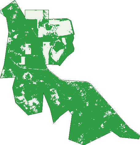
Green: 10 m cells where trees dominate, satellite 2021. Blue: water. The line is the suburb boundary.
| Canopy share, 1 m canopy height map, 2020 | 31.4% |
|---|---|
| Land with trees, 10 m satellite map, 2021 | 82.5% |
Demographics
Top ancestries in Murrumujuk
| Irish | 5 |
|---|---|
| English | 3 |
| Australian | 0 |
| Aboriginal | 0 |
| Chinese | 0 |
| Croatian | 0 |
Top countries of birth in Murrumujuk
| England | 3 |
|---|
Birds & Wildlife Nearby
90 bird observations recorded near Murrumujuk — most often seen:
- Brown-capped Emerald-dove (9)
- Magpie-lark (8)
- Pied Butcherbird (4)
- Red-tailed Black Cockatoo (4)
- Tawny Frogmouth (4)
- Australian Owlet-nightjar (3)
- Australian Pelican (3)
- Black Kite (3)
- Black-faced Cuckoo-shrike (3)
- Blue-winged Kookaburra (3)
- Intermediate Egret (3)
- Masked Lapwing (3)
- Nankeen Kestrel (3)
Show all 30 birds recorded near Murrumujuk
- Silver-backed Butcherbird (3)
- Silver-crowned Friarbird (3)
- Southern Boobook (3)
- Australian Pratincole (2)
- Blue-faced Honeyeater (2)
- Brolga (2)
- Cattle Egret (2)
- Forest Kingfisher (2)
- Galah (2)
- Glossy Ibis (2)
- Great Egret (2)
- Little Friarbird (2)
- Mistletoebird (2)
- Pied Heron (2)
- Rainbow Bee-eater (2)
- Rainbow Lorikeet (2)
- Red-backed Button-quail (2)
Sightings reported by observers, not a survey, so the counts show what people record rather than what lives here. Source: Atlas of Living Australia.
Nearby Suburbs
The closest suburbs to Murrumujuk:
- Glyde Point (10.4 km)
- Gunn Point (11.5 km)
- Koolpinyah (14.6 km)
- Shoal Bay (15.1 km)
- Buffalo Creek (16.8 km)
- Micket Creek (18.1 km)
- Holmes (20.3 km)
- Holtze (20.6 km)
Embed this suburb
Add this free Murrumujuk stat card to your own site — just copy the code:
Preview:
Cite this page
Quoting these figures? Copy the credit line:
Keep an eye on Murrumujuk
One email when this data meaningfully changes — new census figures, prices, rankings. No spam, unsubscribe anytime.
Streets
- Gunn Point Road (1)