Worrigee NSW 2540
2,194 addresses · 87 streets
Gilmore Electorate › Shoalhaven LGA › Worrigee · 126 km from Sydney
📦 Thinking of moving here? Read the Worrigee moving guide

Living Here
Worrigee is a suburb of New South Wales, home to about 5,384 people, with a median age of 33. The typical household earns around $1,586 a week, with median rent near $390 a week. Most homes are houses. About 64% of households own their home and 35% rent. Most workers drive to work. Common community backgrounds include Australian, English, Aboriginal. On the ABS socio-economic scale it sits in decile 3 of 10 nationally — a more disadvantaged area.
Over time — Census 2001 → 2021
Dashed line: district figures for the Nowra statistical area (SA2), the smallest area the ABS published before 2011. Solid line: Worrigee itself.
Getting Around & Local Services
2 cafés & restaurants
1 supermarket
1 Catholic church
1 medical clinic
1 optometrist
1 childcare centre
1 library
2 post offices
10 service stations
3 gyms & sports centres
2 golf clubs
1 butcher
3 hardware stores
1 plumber
Getting around. Train station: Bomaderry, 5.2 km north · Airport: HMAS Albatross, 8.9 km south-west.
Socio-economic Standing
Deciles from 1 (lowest) to 10 (highest), against all Australian suburbs. The overall figure weighs advantage and disadvantage together; economic resources counts income and housing, and education & jobs counts qualifications and occupation. They often differ. Source: ABS SEIFA 2021.
Tree cover
🌳 Tree canopy: 42.2% share of land under canopy · satellite map, 2020
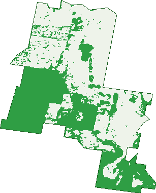
Green: 10 m cells where trees dominate, satellite 2021. Blue: water. The line is the suburb boundary.
| Canopy share, 1 m canopy height map, 2020 | 42.2% |
|---|---|
| Land with trees, 10 m satellite map, 2021 | 44.6% |
Demographics
Unemployment 4.8% · Labour-force participation 62%
Population by age in Worrigee
| 0-4 | 431 |
|---|---|
| 5-14 | 874 |
| 15-19 | 352 |
| 20-24 | 368 |
| 25-34 | 767 |
| 35-44 | 641 |
| 45-54 | 659 |
| 55-64 | 504 |
| 65-74 | 443 |
| 75-84 | 279 |
| 85+ | 64 |
Dwelling types in Worrigee
| House | 1,706 |
|---|---|
| Townhouse | 90 |
| Apartment | 20 |
| Other | 0 |
Households by weekly income in Worrigee
| <$650 | 235 |
|---|---|
| $650-1,499 | 566 |
| $1,500-2,999 | 628 |
| $3,000+ | 250 |
Top ancestries in Worrigee
| Australian | 2,470 |
|---|---|
| English | 2,228 |
| Aboriginal | 523 |
| Irish | 500 |
| Scottish | 478 |
| Other | 335 |
Housing tenure in Worrigee
| Owned | 530 |
|---|---|
| Mortgage | 622 |
| Rented | 630 |
| Other | 11 |
Cars per household in Worrigee
| 0 | 41 |
|---|---|
| 1 | 580 |
| 2 | 759 |
| 3 | 250 |
| 4+ | 173 |
Commute to work in Worrigee
| Car | 1,850 |
|---|---|
| Train | 3 |
| Bus | 5 |
| Tram/ferry | 0 |
| Walked | 14 |
| Bicycle | 7 |
| Home | 146 |
Top countries of birth in Worrigee
| England | 131 |
|---|---|
| India | 31 |
| New Zealand | 29 |
| Philippines | 23 |
| Thailand | 19 |
| Scotland | 16 |
Languages used at home in Worrigee
| Cantonese | 19 |
|---|---|
| Thai | 18 |
| Spanish | 17 |
| Bengali | 15 |
| Hindi | 14 |
| Portuguese | 12 |
Birds & Wildlife Nearby
22,816 bird observations recorded near Worrigee — most often seen:
- Magpie-lark (1,379)
- Rainbow Lorikeet (1,356)
- Australian Magpie (1,319)
- Pacific Black Duck (1,095)
- Australian Raven (1,014)
- Common Myna (928)
- Laughing Kookaburra (900)
- Australian Wood Duck (863)
- Red Wattlebird (840)
- Little Corella (837)
- Chestnut Teal (764)
- Willie Wagtail (759)
- Welcome Swallow (750)
Show all 30 birds recorded near Worrigee
- Yellow-faced Honeyeater (733)
- Masked Lapwing (678)
- Sulphur-crested Cockatoo (677)
- Eurasian Coot (659)
- Superb Fairy-wren (632)
- Galah (600)
- Dusky Moorhen (590)
- Eastern Yellow Robin (585)
- Australasian Purple Swamphen (580)
- Grey Fantail (564)
- Satin Bowerbird (551)
- Eurasian Blackbird (542)
- Grey Butcherbird (538)
- White-faced Heron (533)
- Spotted Turtle-dove (532)
- Spotted Pardalote (530)
- Black-faced Cuckoo-shrike (488)
Sightings reported by observers, not a survey, so the counts show what people record rather than what lives here. Source: Atlas of Living Australia.
Nearby Suburbs
The closest suburbs to Worrigee:
- South Nowra (2.4 km)
- Nowra (2.7 km)
- Brundee (2.9 km)
- Terara (3.6 km)
- West Nowra (3.9 km)
- Mayfield (4.4 km)
- Numbaa (5.3 km)
- Comberton (5.4 km)
Embed this suburb
Add this free Worrigee stat card to your own site — just copy the code:
Preview:
Cite this page
Quoting these figures? Copy the credit line:
Keep an eye on Worrigee
One email when this data meaningfully changes — new census figures, prices, rankings. No spam, unsubscribe anytime.
Streets
- Abelia Place (10)
- Acer Place (10)
- Aldous Place (12)
- Almond Grove (11)
- Almondbark Road (41)
- Andrew Crescent (9)
- Apollo Crescent (9)
- Arthur Street (69)
- Asteria Street (21)
- Athena Crescent (9)
- Balira Place (11)
- Basil Street (18)
- Bennett Place (22)
- Blue Bell Way (48)
- Blueberry Street (6)
- Bluewattle Road (36)
- Booligal Road (4)
- Boston Road (12)
- Burralee Drive (5)
- Cherry Plum Way (5)
- Coachwood Avenue (24)
- Copper Leaf Place (10)
- Coral Gum Court (20)
- Correa Court (10)
- Costa Street (28)
- Daisy Place (7)
- Ebony Link (8)
- Elderberry Avenue (27)
- Ellison Close (7)
- Eucalyptus Avenue (38)
- Flanagan Court (29)
- Forest Meadows Way (7)
- Forestpark Road (15)
- Garden Grove (6)
- Golden Ash Close (37)
- Golden Grove (35)
- Greenwell Point Road (33)
- Guinea Flower Crescent (33)
- Hannah Place (25)
- Hermes Crescent (22)
- Illawarra Circuit (50)
- Isa Road (138)
- Jewel Street (25)
- Juniper Place (24)
- Kalatta Grove (9)
- Kauri Street (27)
- Lacebark Grove (43)
- Liberty Road (9)
- Lilac Close (2)
- Litoria Parade (11)
- Manningvale Close (4)
- Marsden Close (14)
- Mcternan Place (17)
- Millbank Road (9)
- Mintbush Crescent (30)
- Mountain Ash Place (27)
- Neptune Place (13)
- Oakbanks Place (12)
- Old Southern Road (45)
- Palm Lilly Close (14)
- Peachtree Close (6)
- Pella Crescent (6)
- Peppermint Drive (68)
- Plato Crescent (8)
- Rayleigh Drive (127)
- Regelia Parade (8)
- Reign Close (6)
- Riveroak Road (42)
- Robinia Way (57)
- Rock Lilly Close (7)
- Royal Street (34)
- Socrates Place (27)
- Sophia Road (145)
- Springbank Road (5)
- St James Crescent (37)
- Stanbury Place (11)
- Sugarwood Road (49)
- Sullivan Street (34)
- Swanwood Rise (5)
- Tallais Close (9)
- Tallon Way (10)
- Tee Close (19)
- The Garden Walk (40)
- Watergum Road (3)
- Whitewood Street (14)
- Worrigee Road (79)
- Wyanga Crescent (26)