Wingham NSW 2429
3,206 addresses · 128 streets
Lyne Electorate › Mid-Coast LGA › Wingham · 247 km from Sydney
📦 Thinking of moving here? Read the Wingham moving guide

Living Here
Wingham is a suburb of New South Wales, home to about 5,395 people, with a median age of 47. The typical household earns around $1,105 a week, with median rent near $306 a week. Most homes are houses. About 76% of households own their home and 23% rent. Most workers drive to work. Common community backgrounds include Australian, English, Scottish. On the ABS socio-economic scale it sits in decile 1 of 10 nationally — a more disadvantaged area.
Over time — Census 2001 → 2021
Dashed line: district figures for the Wingham statistical area (SA2), the smallest area the ABS published before 2011. Solid line: Wingham itself.
Getting Around & Local Services
4 cafés & restaurants
1 supermarket
2 pharmacies
1 dentist
1 childcare centre
1 library
1 post office
3 service stations
2 gyms & sports centres
1 golf club
3 bakeries
2 butchers
3 places to stay
Getting around. Train station: Wingham, 300 m east · Airport: Taree Airport, 14 km east.
Socio-economic Standing
Deciles from 1 (lowest) to 10 (highest), against all Australian suburbs. The overall figure weighs advantage and disadvantage together; economic resources counts income and housing, and education & jobs counts qualifications and occupation. They often differ. Source: ABS SEIFA 2021.
Tree cover
🌳 Tree canopy: 34.5% share of land under canopy · satellite map, 2020
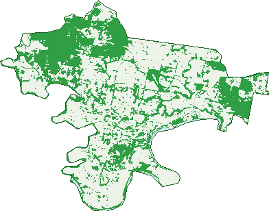
Green: 10 m cells where trees dominate, satellite 2021. Blue: water. The line is the suburb boundary.
| Canopy share, 1 m canopy height map, 2020 | 34.5% |
|---|---|
| Land with trees, 10 m satellite map, 2021 | 38.2% |
Demographics
Unemployment 7.1% · Labour-force participation 48.3%
Population by age in Wingham
| 0-4 | 292 |
|---|---|
| 5-14 | 683 |
| 15-19 | 272 |
| 20-24 | 244 |
| 25-34 | 557 |
| 35-44 | 514 |
| 45-54 | 612 |
| 55-64 | 843 |
| 65-74 | 755 |
| 75-84 | 457 |
| 85+ | 171 |
Dwelling types in Wingham
| House | 1,957 |
|---|---|
| Townhouse | 93 |
| Apartment | 61 |
| Other | 15 |
Households by weekly income in Wingham
| <$650 | 526 |
|---|---|
| $650-1,499 | 767 |
| $1,500-2,999 | 530 |
| $3,000+ | 151 |
Top ancestries in Wingham
| Australian | 2,468 |
|---|---|
| English | 2,466 |
| Scottish | 552 |
| Irish | 507 |
| Aboriginal | 373 |
| Ancestry NS | 353 |
Housing tenure in Wingham
| Owned | 920 |
|---|---|
| Mortgage | 655 |
| Rented | 473 |
| Other | 25 |
Cars per household in Wingham
| 0 | 119 |
|---|---|
| 1 | 793 |
| 2 | 768 |
| 3 | 230 |
| 4+ | 162 |
Commute to work in Wingham
| Car | 1,528 |
|---|---|
| Train | 0 |
| Bus | 5 |
| Tram/ferry | 0 |
| Walked | 65 |
| Bicycle | 5 |
| Home | 107 |
Top countries of birth in Wingham
| England | 118 |
|---|---|
| New Zealand | 44 |
| Germany | 18 |
| Scotland | 15 |
| United States | 14 |
| Philippines | 13 |
Languages used at home in Wingham
| Mandarin | 12 |
|---|---|
| German | 11 |
| French | 10 |
| Australian Indigenous | 9 |
| Portuguese | 9 |
| Spanish | 8 |
Birds & Wildlife Nearby
5,888 bird observations recorded near Wingham — most often seen:
- Australian Brush-turkey (445)
- Australian Magpie (313)
- Laughing Kookaburra (288)
- Rainbow Lorikeet (285)
- Lewin's Honeyeater (275)
- Eastern Yellow Robin (271)
- Australian Wood Duck (248)
- Yellow-throated Scrubwren (236)
- Torresian Crow (234)
- Pacific Black Duck (203)
- Russet-tailed Thrush (203)
- Brown Gerygone (189)
- Grey Fantail (189)
Show all 30 birds recorded near Wingham
- Magpie-lark (187)
- White-headed Pigeon (187)
- White-throated Treecreeper (172)
- Eastern Whipbird (171)
- White-browed Scrubwren (168)
- Australian Torresian Crow (158)
- Welcome Swallow (157)
- Spotted Turtle-dove (154)
- Coastal New South Wales Australian Magpie (143)
- Australasian Figbird (139)
- Grey Shrike-thrush (139)
- Australian King-parrot (136)
- Southern Lewin's Honeyeater (135)
- Australian Pelican (118)
- Galah (116)
- Little Pied Cormorant (115)
- Bar-shouldered Dove (114)
Sightings reported by observers, not a survey, so the counts show what people record rather than what lives here. Source: Atlas of Living Australia.
Nearby Suburbs
The closest suburbs to Wingham:
- The Bight (2.4 km)
- Dollys Flat (5.3 km)
- Bootawa (5.8 km)
- Mondrook (6.2 km)
- Killawarra (6.8 km)
- Cedar Party (6.9 km)
- Karaak Flat (8.5 km)
- Yarratt Forest (9 km)
Embed this suburb
Add this free Wingham stat card to your own site — just copy the code:
Preview:
Cite this page
Quoting these figures? Copy the credit line:
Keep an eye on Wingham
One email when this data meaningfully changes — new census figures, prices, rankings. No spam, unsubscribe anytime.
Streets
- Abbott Street (24)
- Abbotts Falls Road (30)
- Adelaide Close (19)
- Allan Street (39)
- Apanie Close (10)
- Appaloosa Place (3)
- Appletree Street (58)
- Ashlea Road (6)
- Bahanas Close (37)
- Belbourie Street (40)
- Bell Close (6)
- Bent Street (50)
- Blue Gum Avenue (34)
- Boundary Road (1)
- Brushbox Close (16)
- Bulga Road (35)
- Bungay Road (182)
- Campbell Street (25)
- Canget Street (60)
- Carey Road (7)
- Cedar Party Road (4)
- Cedar Street (2)
- Church Crescent (6)
- Church Lane (2)
- Clarke Close (7)
- Clover Street (3)
- Coghlan Avenue (3)
- Coglan Avenue (3)
- Combined Street (71)
- Comboyne Road (29)
- Coroma Place (15)
- Country Club Drive (29)
- Dennes Street (17)
- Dollys Flat Road (2)
- East Combined Street (39)
- Ellenora Circuit (27)
- Farquhar Street (91)
- Felton Place (5)
- Finch Close (4)
- Flett Street (49)
- Fotheringham Street (30)
- George Flemming Road (16)
- Gimlet Place (7)
- Gleeson Close (9)
- Glenyarra Road (11)
- Gloucester Road (98)
- Gollan Street (17)
- Guilding Street (9)
- Helmich Close (19)
- Hereford Close (13)
- High Street (5)
- Hillcrest Avenue (28)
- Honeyeater Place (10)
- Hunter Place (11)
- Industrial Close (13)
- Irvine Street (14)
- Isabella Street (180)
- Jacaranda Avenue (17)
- Kardina Road (15)
- Keech Street (19)
- Kennard Close (1)
- Kerrydell Place (4)
- Khatabundah Road (33)
- Khatabundah Street (12)
- Killawarra Street (80)
- Kindarun Close (3)
- Kingfisher Drive (19)
- Kundibakh Close (4)
- Lambert Street (41)
- Lanark Close (6)
- Links Avenue (9)
- Little Street (17)
- Lobban Road (7)
- Machin Parade (15)
- Mallee Close (23)
- Marchfield Road (39)
- Marlee Street (62)
- Mcpherson Street (42)
- Moon Street (57)
- Mortimer Street (44)
- Mountview Avenue (21)
- Murray Road (78)
- Myah Close (7)
- Pearson Place (20)
- Phillip Close (7)
- Price Street (7)
- Primrose Street (78)
- Queen Street (81)
- Racecourse Road (4)
- Richardson Street (63)
- Rifle Range Road (2)
- Riverview Drive (25)
- Rosella Drive (19)
- Rouse Street (40)
- Rowley Street (17)
- Ruth Street (13)
- Skinner Street (18)
- Skyline Drive (45)
- South Dennes Street (10)
- Spotted Gum Close (3)
- Steele Street (8)
- Stockyard Circuit (63)
- Stone Lane (3)
- Stringybark Close (15)
- Summerland Close (6)
- Summerville Street (82)
- Sunrise Lane (4)
- Sunset Avenue (20)
- The Bunker (6)
- The Cedars Drive (16)
- Treetops Parade (21)
- Tyrone Street (19)
- Viscount Road (3)
- Vista Drive (18)
- Wallaby Joe Road (14)
- Warrawillah Avenue (26)
- West Appletree Street (14)
- West Street (2)
- Wherrol Flat Road (2)
- Wilander Drive (1)
- William Street (32)
- Wingham Circuit (8)
- Wingham Road (41)
- Worthing Lane (5)
- Wynter Street (9)
- Wyoming Street (34)
- Youngs Road (26)
- Zeal Lane (1)