Werrington NSW 2747
3,347 addresses · 73 streets
Lindsay Electorate › Penrith LGA › Werrington · 44 km from Sydney
📦 Thinking of moving here? Read the Werrington moving guide

Living Here
Werrington is a suburb of New South Wales, home to about 5,328 people, with a median age of 32. The typical household earns around $1,605 a week, with median rent near $360 a week. Most homes are houses. About 53% of households own their home and 46% rent. Most workers drive to work. Common community backgrounds include Australian, English, Ancestry NS. On the ABS socio-economic scale it sits in decile 3 of 10 nationally — a more disadvantaged area.
Over time — Census 2001 → 2021
Dashed line: district figures for the Kingswood - Werrington statistical area (SA2), the smallest area the ABS published before 2011. Solid line: Werrington itself.
Getting Around & Local Services
3 physiotherapists
10 childcare & kindergartens
- Sunflower Childcare Centre
- Yoorami Childrens Centre
- Werrington County Childrens Centre
- Lifetime Learners Daycare & Preschool
- Learning Adventures Kingswood
- The Little Village Early Learning Centre
- Werrianda Children's Centre
- Caddens Kids Childcare Centre
- Cambridge Park Public School Preschool
- Bright Stars Kindergarten-Early Learning
2 dog parks
2 butchers
1 carpenter
Getting around. Train station: Werrington, 550 m east · Bus interchange: St Marys Temporary Bus Interchange, 2.2 km east · Airport: Western Sydney International Airport, 14.6 km south.
Socio-economic Standing
Deciles from 1 (lowest) to 10 (highest), against all Australian suburbs. The overall figure weighs advantage and disadvantage together; economic resources counts income and housing, and education & jobs counts qualifications and occupation. They often differ. Source: ABS SEIFA 2021.
Tree cover
🌳 Tree canopy: 13.8% share of land under canopy · satellite map, 2020
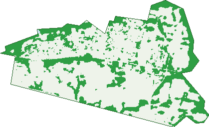
Green: 10 m cells where trees dominate, satellite 2021. Blue: water. The line is the suburb boundary.
| Canopy share, 1 m canopy height map, 2020 | 13.8% |
|---|---|
| Surveyed canopy, Greater Sydney aerial survey, 2019 | 12.1% |
| Land with trees, 10 m satellite map, 2021 | 27.9% |
Demographics
Unemployment 7% · Labour-force participation 61%
Population by age in Werrington
| 0-4 | 462 |
|---|---|
| 5-14 | 762 |
| 15-19 | 306 |
| 20-24 | 405 |
| 25-34 | 945 |
| 35-44 | 890 |
| 45-54 | 615 |
| 55-64 | 440 |
| 65-74 | 341 |
| 75-84 | 138 |
| 85+ | 34 |
Dwelling types in Werrington
| House | 812 |
|---|---|
| Townhouse | 708 |
| Apartment | 358 |
| Other | 0 |
Households by weekly income in Werrington
| <$650 | 279 |
|---|---|
| $650-1,499 | 550 |
| $1,500-2,999 | 676 |
| $3,000+ | 272 |
Top ancestries in Werrington
| Australian | 1,453 |
|---|---|
| English | 1,278 |
| Other | 1,212 |
| Ancestry NS | 409 |
| Indian | 341 |
| Irish | 325 |
Housing tenure in Werrington
| Owned | 298 |
|---|---|
| Mortgage | 685 |
| Rented | 865 |
| Other | 19 |
Cars per household in Werrington
| 0 | 206 |
|---|---|
| 1 | 844 |
| 2 | 602 |
| 3 | 146 |
| 4+ | 61 |
Commute to work in Werrington
| Car | 1,185 |
|---|---|
| Train | 141 |
| Bus | 13 |
| Tram/ferry | 0 |
| Walked | 9 |
| Bicycle | 0 |
| Home | 534 |
Top countries of birth in Werrington
| India | 302 |
|---|---|
| Philippines | 230 |
| Nepal | 165 |
| New Zealand | 165 |
| England | 77 |
| China | 61 |
Languages used at home in Werrington
| Nepali | 211 |
|---|---|
| Punjabi | 140 |
| Tagalog | 127 |
| Hindi | 89 |
| Arabic | 87 |
| Samoan | 73 |
Birds & Wildlife Nearby
28,720 bird observations recorded near Werrington — most often seen:
- Noisy Miner (2,012)
- Rainbow Lorikeet (1,953)
- Australian Magpie (1,951)
- Common Myna (1,727)
- Australian Raven (1,582)
- Magpie-lark (1,498)
- Spotted Turtle-dove (1,116)
- Rock Dove (1,047)
- Superb Fairy-wren (1,013)
- Common Starling (931)
- Australian White Ibis (926)
- Masked Lapwing (920)
- Willie Wagtail (853)
Show all 30 birds recorded near Werrington
- Pied Currawong (813)
- Welcome Swallow (812)
- Pacific Black Duck (773)
- Crested Pigeon (738)
- Grey Butcherbird (737)
- Dusky Moorhen (681)
- Sulphur-crested Cockatoo (664)
- Australian Wood Duck (643)
- Galah (643)
- Yellow-faced Honeyeater (622)
- House Sparrow (604)
- Australasian Purple Swamphen (603)
- Black-faced Cuckoo-shrike (588)
- Yellow Thornbill (576)
- Red-whiskered Bulbul (574)
- Eastern Rosella (573)
- Emu (547)
Sightings reported by observers, not a survey, so the counts show what people record rather than what lives here. Source: Atlas of Living Australia.
Nearby Suburbs
The closest suburbs to Werrington:
- Werrington County (1.4 km)
- Claremont Meadows (2 km)
- Caddens (2.4 km)
- St Marys (2.6 km)
- Werrington Downs (2.6 km)
- Cambridge Park (2.7 km)
- North St Marys (2.8 km)
- Kingswood (3 km)
Embed this suburb
Add this free Werrington stat card to your own site — just copy the code:
Preview:
Cite this page
Quoting these figures? Copy the credit line:
Keep an eye on Werrington
One email when this data meaningfully changes — new census figures, prices, rankings. No spam, unsubscribe anytime.
Streets
- Abacus Parade (47)
- Albert Street (289)
- Andro Place (11)
- Apple Street (14)
- Armstein Crescent (34)
- Bellwood Close (22)
- Bridge Street (3)
- Burringora Street (18)
- Burton Street (31)
- Cargo Street (20)
- Carleen Close (9)
- Catherine Street (4)
- Chapman Street (130)
- Chrisan Close (9)
- Corymbia Road (27)
- Cottage Street (29)
- Creek Road (1)
- Danny Street (35)
- Depot Circuit (55)
- Deslie Avenue (9)
- Dunheved Road (2)
- Dunkley Place (23)
- Edward Close (9)
- Elaine Court (8)
- Eve Street (28)
- Gauge Street (5)
- Gazelle Place (6)
- Gibson Avenue (141)
- Gipps Street (3)
- Great Western Highway (36)
- Heavey Street (49)
- Impala Avenue (24)
- Innes Place (9)
- Irwin Street (147)
- Isabella Street (18)
- John Oxley Avenue (11)
- Judith Close (30)
- Kanooka Street (5)
- Kazanis Court (37)
- Kirsh Street (54)
- L'estrange Street (28)
- Lack Place (11)
- Landers Street (20)
- Lethbridge Avenue (78)
- Lloyd Street (26)
- Major Tomkins Parade (52)
- Malcolm Avenue (10)
- Meyer Street (34)
- Paling Street (12)
- Parkes Avenue (96)
- Peartree Circuit (115)
- Plumcott Street (12)
- Princess Street (249)
- Railway Street (43)
- Rance Road (115)
- Reid Street (77)
- Reindeer Place (30)
- Roebuck Road (22)
- Rosewood Way (8)
- Semaan Street (14)
- Signal Street (17)
- Spinifex Road (36)
- Spur Street (15)
- St Charbel Boulevard (23)
- Steam Lane (18)
- Tennant Road (4)
- The Kingsway (4)
- Tramway Avenue (17)
- Victoria Street (577)
- Walker Street (95)
- Water Street (9)
- Werrington Road (10)
- William Street (28)