Werrington County NSW 2747
1,558 addresses · 61 streets
Lindsay Electorate › Penrith LGA › Werrington County · 45 km from Sydney
📦 Thinking of moving here? Read the Werrington County moving guide

Living Here
Werrington County is a suburb of New South Wales, home to about 3,698 people, with a median age of 37. The typical household earns around $2,042 a week, with median rent near $415 a week. Most homes are houses. About 80% of households own their home and 19% rent. Most workers drive to work. Common community backgrounds include Australian, English, Irish. On the ABS socio-economic scale it sits in decile 5 of 10 nationally — a mid-range area.
Over time — Census 2001 → 2021
Dashed line: district figures for the Cambridge Park statistical area (SA2), the smallest area the ABS published before 2011. Solid line: Werrington County itself.
Getting Around & Local Services
2 pharmacies
3 doctors & medical clinics
11 childcare & kindergartens
- Werrington County Childrens Centre
- Werrianda Children's Centre
- Yoorami Childrens Centre
- Cambridge Park Public School Preschool
- Learning Adventures Kingswood
- Bright Stars Kindergarten-Early Learning
- Rainbow Cottage Children's Centre
- Wattle Glenn Children's Centre
- Sunflower Childcare Centre
- The Little Village Early Learning Centre
See all 11 childcare & kindergartens near Werrington County →
2 dog parks
2 butchers
1 carpenter
Getting around. Train station: Werrington, 1.9 km south-east · Bus interchange: Western Shuttle Bus Stop, 3.2 km south-west · Airport: Western Sydney International Airport, 15.7 km south.
Socio-economic Standing
Deciles from 1 (lowest) to 10 (highest), against all Australian suburbs. The overall figure weighs advantage and disadvantage together; economic resources counts income and housing, and education & jobs counts qualifications and occupation. They often differ. Source: ABS SEIFA 2021.
Tree cover
🌳 Tree canopy: 19.2% share of land under canopy · satellite map, 2020
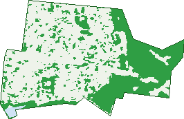
Green: 10 m cells where trees dominate, satellite 2021. Blue: water. The line is the suburb boundary.
| Canopy share, 1 m canopy height map, 2020 | 19.2% |
|---|---|
| Surveyed canopy, Greater Sydney aerial survey, 2019 | 16.3% |
| Land with trees, 10 m satellite map, 2021 | 34.4% |
Demographics
Unemployment 2.9% · Labour-force participation 62.6%
Population by age in Werrington County
| 0-4 | 244 |
|---|---|
| 5-14 | 499 |
| 15-19 | 189 |
| 20-24 | 229 |
| 25-34 | 533 |
| 35-44 | 547 |
| 45-54 | 422 |
| 55-64 | 413 |
| 65-74 | 443 |
| 75-84 | 128 |
| 85+ | 45 |
Dwelling types in Werrington County
| House | 1,231 |
|---|---|
| Townhouse | 6 |
| Apartment | 4 |
| Other | 0 |
Households by weekly income in Werrington County
| <$650 | 132 |
|---|---|
| $650-1,499 | 300 |
| $1,500-2,999 | 466 |
| $3,000+ | 266 |
Top ancestries in Werrington County
| Australian | 1,458 |
|---|---|
| English | 1,348 |
| Irish | 386 |
| Other | 334 |
| Scottish | 313 |
| Aboriginal | 226 |
Housing tenure in Werrington County
| Owned | 433 |
|---|---|
| Mortgage | 561 |
| Rented | 240 |
| Other | 9 |
Cars per household in Werrington County
| 0 | 44 |
|---|---|
| 1 | 352 |
| 2 | 513 |
| 3 | 213 |
| 4+ | 116 |
Commute to work in Werrington County
| Car | 1,004 |
|---|---|
| Train | 19 |
| Bus | 6 |
| Tram/ferry | 0 |
| Walked | 8 |
| Bicycle | 0 |
| Home | 414 |
Top countries of birth in Werrington County
| England | 110 |
|---|---|
| New Zealand | 76 |
| India | 56 |
| Philippines | 37 |
| Scotland | 29 |
| China | 17 |
Languages used at home in Werrington County
| Arabic | 26 |
|---|---|
| Punjabi | 22 |
| Hindi | 20 |
| Italian | 17 |
| Tagalog | 16 |
| Tamil | 14 |
Birds & Wildlife Nearby
29,797 bird observations recorded near Werrington County — most often seen:
- Rainbow Lorikeet (2,292)
- Noisy Miner (2,168)
- Australian Magpie (2,040)
- Common Myna (1,725)
- Australian Raven (1,671)
- Magpie-lark (1,619)
- Spotted Turtle-dove (1,162)
- Rock Dove (1,058)
- Superb Fairy-wren (1,056)
- Australian White Ibis (955)
- Masked Lapwing (943)
- Willie Wagtail (887)
- Welcome Swallow (878)
Show all 30 birds recorded near Werrington County
- Pied Currawong (830)
- Pacific Black Duck (826)
- Common Starling (818)
- Crested Pigeon (746)
- Dusky Moorhen (737)
- Grey Butcherbird (735)
- Sulphur-crested Cockatoo (687)
- Australian Wood Duck (667)
- Galah (664)
- Yellow-faced Honeyeater (623)
- Australasian Purple Swamphen (613)
- Black-faced Cuckoo-shrike (577)
- House Sparrow (571)
- Yellow Thornbill (570)
- Laughing Kookaburra (569)
- Emu (556)
- Eastern Rosella (554)
Sightings reported by observers, not a survey, so the counts show what people record rather than what lives here. Source: Atlas of Living Australia.
Nearby Suburbs
The closest suburbs to Werrington County:
- Werrington Downs (1.3 km)
- Werrington (1.4 km)
- Cambridge Park (1.8 km)
- Jordan Springs (2.3 km)
- Cambridge Gardens (2.4 km)
- Llandilo (2.7 km)
- Kingswood (2.9 km)
- Claremont Meadows (3.2 km)
Embed this suburb
Add this free Werrington County stat card to your own site — just copy the code:
Preview:
Cite this page
Quoting these figures? Copy the credit line:
Keep an eye on Werrington County
One email when this data meaningfully changes — new census figures, prices, rankings. No spam, unsubscribe anytime.
Streets
- Angas Street (11)
- Angel Street (10)
- Bannister Way (16)
- Berry Place (8)
- Beverley Place (10)
- Blackman Court (14)
- Boyd Place (8)
- Bunce Place (7)
- Burke Avenue (22)
- Burton Street (35)
- Chambers Street (7)
- Charles Sturt Drive (24)
- Charles Todd Crescent (58)
- Chisholm Avenue (35)
- Cofton Court (14)
- Colling Avenue (6)
- Colson Crescent (26)
- Daly Court (5)
- Dampier Avenue (22)
- Druitt Place (11)
- Dunbar Avenue (17)
- Dunheved Road (52)
- Dunmore Place (5)
- Elder Place (24)
- Eyre Street (2)
- Fawkener Place (16)
- Francis Street (5)
- Gillen Court (4)
- Glencoe Avenue (60)
- Hacking Avenue (7)
- Hartley Place (6)
- Hartog Drive (40)
- Hawdon Avenue (26)
- Hely Court (7)
- Henry Lawson Avenue (198)
- Hentic Court (11)
- Hume Crescent (110)
- Hunt Place (6)
- John Batman Avenue (34)
- John Oxley Avenue (58)
- Lavin Crescent (9)
- Leichhardt Avenue (1)
- Leslie Court (10)
- Lockyer Avenue (57)
- Madigan Drive (50)
- Mawson Court (12)
- Meehan Avenue (6)
- Oldham Avenue (26)
- Orleton Place (21)
- Ovens Drive (29)
- Poole Street (32)
- Prince Street (29)
- Reid Street (2)
- Romaine Avenue (10)
- Rugby Street (57)
- Shortland Street (13)
- Singleton Avenue (22)
- Thomas Bell Avenue (30)
- Warburton Crescent (88)
- Wilde Place (8)
- Wiley Court (9)