Wauchope NSW 2446
4,207 addresses · 132 streets
Lyne Electorate › Port Macquarie-Hastings LGA › Wauchope · 303 km from Sydney
📦 Thinking of moving here? Read the Wauchope moving guide

Living Here
Wauchope is a suburb of New South Wales, home to about 6,589 people, with a median age of 43. The typical household earns around $1,114 a week, with median rent near $350 a week. Most homes are houses. About 65% of households own their home and 33% rent. Most workers drive to work. Common community backgrounds include Australian, English, Irish. On the ABS socio-economic scale it sits in decile 1 of 10 nationally — a more disadvantaged area.
Over time — Census 2001 → 2021
Dashed line: district figures for the Wauchope statistical area (SA2), the smallest area the ABS published before 2011. Solid line: Wauchope itself.
Getting Around & Local Services
2 supermarkets
2 Catholic churches
1 medical clinic
2 optometrists
1 childcare centre
1 library
1 post office
1 golf club
1 playground
1 bakery
1 hairdresser
1 mechanic
2 places to stay
Getting around. Train station: Wauchope, 1.4 km north-east · Airport: Port Macquarie Airport, 13.6 km east.
Socio-economic Standing
Deciles from 1 (lowest) to 10 (highest), against all Australian suburbs. The overall figure weighs advantage and disadvantage together; economic resources counts income and housing, and education & jobs counts qualifications and occupation. They often differ. Source: ABS SEIFA 2021.
Tree cover
🌳 Tree canopy: 27.5% share of land under canopy · satellite map, 2020
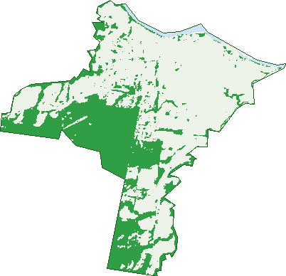
Green: 10 m cells where trees dominate, satellite 2021. Blue: water. The line is the suburb boundary.
| Canopy share, 1 m canopy height map, 2020 | 27.5% |
|---|---|
| Land with trees, 10 m satellite map, 2021 | 34.8% |
Demographics
Unemployment 6.2% · Labour-force participation 49.4%
Population by age in Wauchope
| 0-4 | 381 |
|---|---|
| 5-14 | 876 |
| 15-19 | 409 |
| 20-24 | 345 |
| 25-34 | 751 |
| 35-44 | 624 |
| 45-54 | 770 |
| 55-64 | 762 |
| 65-74 | 818 |
| 75-84 | 580 |
| 85+ | 281 |
Dwelling types in Wauchope
| House | 2,173 |
|---|---|
| Townhouse | 315 |
| Apartment | 38 |
| Other | 20 |
Households by weekly income in Wauchope
| <$650 | 594 |
|---|---|
| $650-1,499 | 962 |
| $1,500-2,999 | 648 |
| $3,000+ | 166 |
Top ancestries in Wauchope
| Australian | 3,022 |
|---|---|
| English | 2,847 |
| Irish | 708 |
| Aboriginal | 635 |
| Scottish | 603 |
| Ancestry NS | 438 |
Housing tenure in Wauchope
| Owned | 916 |
|---|---|
| Mortgage | 714 |
| Rented | 816 |
| Other | 56 |
Cars per household in Wauchope
| 0 | 163 |
|---|---|
| 1 | 1,028 |
| 2 | 880 |
| 3 | 272 |
| 4+ | 150 |
Commute to work in Wauchope
| Car | 1,856 |
|---|---|
| Train | 0 |
| Bus | 9 |
| Tram/ferry | 0 |
| Walked | 67 |
| Bicycle | 4 |
| Home | 153 |
Top countries of birth in Wauchope
| England | 161 |
|---|---|
| New Zealand | 76 |
| Philippines | 24 |
| Germany | 14 |
| Thailand | 14 |
| Netherlands | 13 |
Languages used at home in Wauchope
| Australian Indigenous | 17 |
|---|---|
| French | 15 |
| Mandarin | 10 |
| Thai | 7 |
| Vietnamese | 7 |
| Arabic | 6 |
Birds & Wildlife Nearby
17,193 bird observations recorded near Wauchope — most often seen:
- Pacific Black Duck (1,075)
- Australasian Purple Swamphen (949)
- Rainbow Lorikeet (895)
- Australian Wood Duck (883)
- Eurasian Coot (782)
- Laughing Kookaburra (676)
- Magpie-lark (669)
- Torresian Crow (644)
- Hardhead (620)
- Australian Magpie (615)
- Dusky Moorhen (611)
- Common Myna (596)
- Masked Lapwing (575)
Show all 30 birds recorded near Wauchope
- Comb-crested Jacana (545)
- Little Black Cormorant (536)
- Lewin's Honeyeater (535)
- Australasian Grebe (527)
- Coastal New South Wales Australian Magpie (468)
- Noisy Miner (453)
- Eastern Rainbow Lorikeet (450)
- White-headed Pigeon (430)
- Southern Magpie-lark (422)
- Superb Fairy-wren (421)
- White-faced Heron (420)
- Southern Masked Lapwing (416)
- Australian White Ibis (405)
- Southern Laughing Kookaburra (402)
- Yellow-faced Honeyeater (398)
- Willie Wagtail (394)
- Grey Fantail (381)
Sightings reported by observers, not a survey, so the counts show what people record rather than what lives here. Source: Atlas of Living Australia.
Nearby Suburbs
The closest suburbs to Wauchope:
- Yippin Creek (1.3 km)
- Crosslands (2.6 km)
- King Creek (3.8 km)
- Rosewood (3.8 km)
- Redbank (4.4 km)
- Bago (6.1 km)
- Beechwood (6.3 km)
- Huntingdon (6.7 km)
Embed this suburb
Add this free Wauchope stat card to your own site — just copy the code:
Preview:
Cite this page
Quoting these figures? Copy the credit line:
Keep an eye on Wauchope
One email when this data meaningfully changes — new census figures, prices, rankings. No spam, unsubscribe anytime.
Streets
- Allan Road (44)
- Alma Street (6)
- Anne Street (10)
- Avondale Street (10)
- Azalea Avenue (28)
- Bago Road (24)
- Bain Street (115)
- Ball Crescent (14)
- Beechwood Road (37)
- Blackbutt Drive (83)
- Blacksmith Street (16)
- Bluewater Close (14)
- Blythe Street (13)
- Bob Stanton Close (12)
- Bransdon Street (12)
- Broadaxe Way (9)
- Brushbox Close (4)
- Bruxner Avenue (17)
- Bullock Drive (25)
- Burrawan Drive (49)
- Bushman Drive (36)
- Business Circuit (31)
- Cameron Street (428)
- Campbell Street (54)
- Carpenter Street (14)
- Carrington Street (3)
- Cedar Close (45)
- Charles Street (32)
- Christy Street (2)
- Clareville Avenue (25)
- Clarke Lane (2)
- Cobblers Place (22)
- Cogo Close (11)
- Colonial Circuit (114)
- Commerce Street (70)
- Corymbia Loop (60)
- Cowarral Circuit (63)
- Cowdery Street (20)
- Depot Road (2)
- Drover Street (46)
- Duncan Street (3)
- Elizabeth Street (11)
- Ellenborough Place (18)
- Enterprise Place (6)
- Eucalypts Close (11)
- Fairmont Drive (60)
- Farlow Street (15)
- Farriers Lane (8)
- Fern Close (9)
- Flobern Avenue (32)
- Flobern Street (32)
- Forbes River Road (6)
- Forest Way (23)
- Fox Crescent (14)
- Gowrie Road (82)
- Graham Street (22)
- Guy Street (28)
- Hastings Street (95)
- Heritage Place (20)
- High Street (469)
- Hollis Street (4)
- Homestead Drive (19)
- Industry Street (39)
- Innes Street (11)
- Inventive Way (2)
- Ironbark Close (6)
- Isabel Place (11)
- Ivy Street (7)
- James Street (25)
- Jarrah Way (23)
- Jocks Place (22)
- Johnstone Street (48)
- Joshua Close (21)
- Kerewong Close (6)
- King Creek Road (3)
- King Street (32)
- Kippara Close (14)
- Kookaburra Place (8)
- Kumbatine Close (12)
- Leaders Way (29)
- Little Port Lane (3)
- Mackay Street (5)
- Maher Street (6)
- Mahogany Way (28)
- Marowin Place (11)
- Millers Place (17)
- Millwood Place (11)
- Morton Street (20)
- Nelson Street (12)
- Nursery Lane (25)
- Oakley Way (19)
- Oxley Highway (19)
- Oxley Lane (9)
- Park Street (7)
- Parker Street (13)
- Pead Street (91)
- Peppermint Crescent (31)
- Phillip Street (6)
- Pioneer Place (14)
- Pittman Street (16)
- Princess Avenue (49)
- Production Drive (54)
- Randall Street (39)
- Range Street (38)
- Reservoir Place (19)
- River Street (6)
- Rocks Ferry Road (27)
- Rodlee Street (48)
- Short Street (8)
- Spotted Gum Boulevard (17)
- Stephen Street (14)
- Stockwhip Place (58)
- Stoney Creek Road (2)
- Stringy Bark Avenue (21)
- Sutherland Street (12)
- Tallowood Avenue (34)
- Thatcher Street (6)
- Timbertops Close (9)
- Timbertown Crescent (45)
- Trade Circuit (41)
- Turpentine Crescent (34)
- Wade Street (14)
- Wallace Street (35)
- Warlters Street (48)
- Wattle Street (38)
- Wauchope Cemetery Road (1)
- Waugh Street (69)
- Webb Street (4)
- Weismantle Street (41)
- Whipcrack Terrace (28)
- Yarrat Place (23)
- Young Street (34)