Wallsend NSW 2287
7,636 addresses · 179 streets
Newcastle Electorate › Newcastle LGA › Wallsend · 116 km from Sydney
📦 Thinking of moving here? Read the Wallsend moving guide

Living Here
Wallsend is a suburb of New South Wales, home to about 13,244 people, with a median age of 39. The typical household earns around $1,401 a week, with median rent near $375 a week. Most homes are houses. About 60% of households own their home and 37% rent. Most workers drive to work. Common community backgrounds include Australian, English, Scottish. On the ABS socio-economic scale it sits in decile 3 of 10 nationally — a more disadvantaged area.
Over time — Census 2001 → 2021
Dashed line: district figures for the Wallsend - Elermore Vale statistical area (SA2), the smallest area the ABS published before 2011. Solid line: Wallsend itself.
Getting Around & Local Services
5 supermarkets
2 doctors & medical clinics
2 physiotherapists
5 optometrists
7 service stations
1 bakery
2 hairdressers
2 electricians
1 plumber
Getting around. Train station: Warabrook, 3.9 km north-east · Bus interchange: Newcastle Interchange, 8.4 km east · Airport: Lake Macquarie Airport, 18.2 km south.
Socio-economic Standing
Deciles from 1 (lowest) to 10 (highest), against all Australian suburbs. The overall figure weighs advantage and disadvantage together; economic resources counts income and housing, and education & jobs counts qualifications and occupation. They often differ. Source: ABS SEIFA 2021.
Tree cover
🌳 Tree canopy: 31.3% share of land under canopy · satellite map, 2020
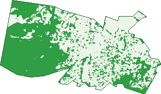
Green: 10 m cells where trees dominate, satellite 2021. Blue: water. The line is the suburb boundary.
| Canopy share, 1 m canopy height map, 2020 | 31.3% |
|---|---|
| Land with trees, 10 m satellite map, 2021 | 48.8% |
Demographics
Unemployment 6% · Labour-force participation 57.3%
Population by age in Wallsend
| 0-4 | 713 |
|---|---|
| 5-14 | 1,349 |
| 15-19 | 688 |
| 20-24 | 1,058 |
| 25-34 | 2,091 |
| 35-44 | 1,580 |
| 45-54 | 1,464 |
| 55-64 | 1,538 |
| 65-74 | 1,308 |
| 75-84 | 885 |
| 85+ | 568 |
Dwelling types in Wallsend
| House | 4,081 |
|---|---|
| Townhouse | 890 |
| Apartment | 252 |
| Other | 23 |
Households by weekly income in Wallsend
| <$650 | 1,079 |
|---|---|
| $650-1,499 | 1,531 |
| $1,500-2,999 | 1,562 |
| $3,000+ | 738 |
Top ancestries in Wallsend
| Australian | 5,185 |
|---|---|
| English | 5,168 |
| Scottish | 1,421 |
| Irish | 1,287 |
| Other | 1,259 |
| Aboriginal | 790 |
Housing tenure in Wallsend
| Owned | 1,542 |
|---|---|
| Mortgage | 1,577 |
| Rented | 1,929 |
| Other | 129 |
Cars per household in Wallsend
| 0 | 463 |
|---|---|
| 1 | 2,047 |
| 2 | 1,849 |
| 3 | 550 |
| 4+ | 280 |
Commute to work in Wallsend
| Car | 3,619 |
|---|---|
| Train | 0 |
| Bus | 78 |
| Tram/ferry | 5 |
| Walked | 91 |
| Bicycle | 23 |
| Home | 1,060 |
Top countries of birth in Wallsend
| England | 225 |
|---|---|
| China | 142 |
| India | 127 |
| Philippines | 114 |
| New Zealand | 110 |
| North Macedonia | 65 |
Languages used at home in Wallsend
| Mandarin | 178 |
|---|---|
| Macedonian | 122 |
| Arabic | 120 |
| Urdu | 63 |
| Bengali | 58 |
| Korean | 57 |
Birds & Wildlife Nearby
80,220 bird observations recorded near Wallsend — most often seen:
- Pacific Black Duck (4,228)
- Australian White Ibis (3,880)
- Australian Magpie (3,821)
- Rainbow Lorikeet (3,755)
- Noisy Miner (3,726)
- Dusky Moorhen (3,676)
- Australasian Purple Swamphen (3,571)
- Eurasian Coot (3,140)
- Chestnut Teal (2,943)
- Superb Fairy-wren (2,745)
- Australian Raven (2,694)
- Australian Wood Duck (2,585)
- Common Myna (2,557)
Show all 30 birds recorded near Wallsend
- Grey Teal (2,427)
- Laughing Kookaburra (2,410)
- Magpie-lark (2,404)
- Australasian Grebe (2,369)
- Sulphur-crested Cockatoo (2,286)
- Great Egret (2,283)
- White-browed Scrubwren (2,263)
- Eastern Rosella (2,222)
- Welcome Swallow (2,181)
- Magpie Goose (2,034)
- Little Pied Cormorant (2,033)
- Southern Noisy Miner (2,031)
- Black Swan (2,023)
- Royal Spoonbill (2,013)
- Silvereye (1,997)
- Spotted Turtle-dove (1,963)
- Coastal New South Wales Australian Magpie (1,960)
Sightings reported by observers, not a survey, so the counts show what people record rather than what lives here. Source: Atlas of Living Australia.
Nearby Suburbs
The closest suburbs to Wallsend:
- Elermore Vale (1.7 km)
- Jesmond (1.9 km)
- Birmingham Gardens (2 km)
- Rankin Park (2.5 km)
- North Lambton (3 km)
- Maryland (3 km)
- Shortland (3.1 km)
- New Lambton Heights (3.3 km)
Embed this suburb
Add this free Wallsend stat card to your own site — just copy the code:
Preview:
Cite this page
Quoting these figures? Copy the credit line:
Keep an eye on Wallsend
One email when this data meaningfully changes — new census figures, prices, rankings. No spam, unsubscribe anytime.
Streets
- Abbott Street (144)
- Abel Lane (1)
- Abel Street (121)
- Alexander Street (14)
- Allendale Avenue (36)
- Andrea Close (32)
- Anna Place (53)
- Ayrfield Close (4)
- Balmoral Close (18)
- Barney Street (17)
- Barrabool Close (17)
- Bean Street (12)
- Bellinger Close (16)
- Benjamin Drive (68)
- Bent Street (17)
- Binney Street (18)
- Birchgrove Drive (134)
- Boambee Close (25)
- Boscawen Street (23)
- Boundary Road (7)
- Boundary Street (42)
- Bousfield Street (170)
- Bowen Street (8)
- Braddon Street (12)
- Brooks Street (74)
- Brown Street (52)
- Bulkara Street (70)
- Bunn Street (24)
- Caledon Close (5)
- Cambronne Parade (1)
- Cameron Street (34)
- Campbell Street (44)
- Cardiff Road (64)
- Carrington Street (13)
- Chalmers Road (38)
- Charles Street (7)
- Charlotte Street (74)
- Clarke Street (49)
- Claymore Close (12)
- Close Street (111)
- Collier Street (14)
- Coorong Close (20)
- Corindi Street (20)
- Corio Close (8)
- Council Street (24)
- Courtney Close (38)
- Coweambah Close (15)
- Cowper Street (117)
- Craignair Close (17)
- Cressington Way (48)
- Crest Road (42)
- Cross Street (9)
- Croudace Road (4)
- Curry Street (70)
- Dan Rees Street (7)
- Dangar Street (56)
- Davis Avenue (95)
- Dennis Place (5)
- Devon Street (127)
- Diana Street (53)
- Dorrigo Street (46)
- Douglas Street (110)
- Downie Lane (4)
- Drury Street (60)
- Drydon Street (47)
- Duckerfield Place (6)
- Elermore Parade (44)
- Ellesmere Road (12)
- Engel Street (6)
- Fletcher Street (95)
- Flinders Street (11)
- Fogo Street (30)
- Frances Street (24)
- Fryar Crescent (35)
- Ganney Road (10)
- Ganur Street (7)
- Garfield Street (4)
- George Street (61)
- Glenogle Crescent (25)
- Gray Street (27)
- Gunambi Street (163)
- Hanley Street (23)
- Hannah Street (64)
- Harriet Street (46)
- Harris Street (10)
- High Street (24)
- Hill Street (70)
- Hope Street (70)
- Illoura Street (29)
- Invermore Close (35)
- Iranda Grove (7)
- Irrawang Street (60)
- Irving Street (73)
- James Street (32)
- John Street (43)
- Jubilee Road (52)
- Kabbarli Court (6)
- Kadina Close (9)
- Kallatina Close (4)
- Kauri Close (15)
- Kemp Street (13)
- Kenneth Street (7)
- Kenrick Street (20)
- Kielawarra Close (8)
- Kirkloch Close (19)
- Kokera Street (99)
- Lake Road (154)
- Lewis Street (42)
- Lily Rose Lane (9)
- Lock Street (5)
- Longworth Avenue (75)
- Low Street (8)
- Lowrey Lane (3)
- Lumsden Lane (13)
- Macquarie Street (113)
- Magin Crescent (44)
- Maitland Street (4)
- Marcus Avenue (8)
- Marie Street (10)
- Martindale Street (77)
- Mcleod Street (16)
- Mcnaughton Avenue (39)
- Metcalfe Street (110)
- Milgate Street (23)
- Minimbah Close (31)
- Minmi Road (146)
- Moani Street (21)
- Moase Street (35)
- Moresby Street (31)
- Mount Street (3)
- Murnin Street (123)
- Myall Street (15)
- Narrier Street (33)
- Nash Street (14)
- Neal Place (3)
- Neilson Street (51)
- Nelson Street (237)
- Newcastle Road (198)
- Oliver Place (9)
- Perks Street (78)
- Peters Avenue (52)
- Philp Place (20)
- Pine Street (9)
- Platt Street (80)
- Raglan Street (71)
- Ranclaud Street (11)
- Remy Close (10)
- Richardson Street (10)
- Robert Street (97)
- Rollicker Court (3)
- Rundle Avenue (64)
- Rushton Street (39)
- Sakonia Close (10)
- Sandgate Road (132)
- Seladon Avenue (44)
- Sherwood Street (37)
- Spargo Lane (3)
- Stapleton Street (76)
- Summerhill Road (3)
- Taylor Street (2)
- The Crescent (48)
- Thomas Street (76)
- Tillie Street (9)
- Turrama Street (37)
- Tyrrell Street (76)
- Udunda Place (6)
- Union Street (5)
- Urara Parade (37)
- Victory Parade (310)
- Walford Street (65)
- Walton Street (10)
- Wardle Close (9)
- Webb Street (19)
- Wentworth Street (116)
- Whitton Street (57)
- Windarra Close (33)
- Wootton Close (7)
- Wyangarie Close (18)
- Youll Street (9)