Ulladulla NSW 2539
5,776 addresses · 142 streets
Gilmore Electorate › Shoalhaven LGA › Ulladulla · 179 km from Sydney
📦 Thinking of moving here? Read the Ulladulla moving guide

Living Here
Ulladulla is a suburb of New South Wales, home to about 7,262 people, with a median age of 51. The typical household earns around $1,007 a week, with median rent near $340 a week. Most homes are houses. About 71% of households own their home and 28% rent. Most workers drive to work. Common community backgrounds include English, Australian, Scottish. On the ABS socio-economic scale it sits in decile 2 of 10 nationally — a more disadvantaged area.
Over time — Census 2001 → 2021
Dashed line: district figures for the Ulladulla statistical area (SA2), the smallest area the ABS published before 2011. Solid line: Ulladulla itself.
Getting Around & Local Services
3 supermarkets
2 Catholic churches
1 pharmacy
1 hospital
1 vet
2 libraries
1 post office
5 service stations
2 gyms & sports centres
2 bakeries
2 hardware stores
1 hairdresser
1 mechanic
Getting around. Airport: HMAS Albatross, 46.5 km north.
Socio-economic Standing
Deciles from 1 (lowest) to 10 (highest), against all Australian suburbs. The overall figure weighs advantage and disadvantage together; economic resources counts income and housing, and education & jobs counts qualifications and occupation. They often differ. Source: ABS SEIFA 2021.
Tree cover
🌳 Tree canopy: 45.4% share of land under canopy · satellite map, 2020
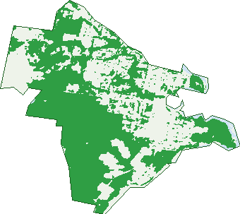
Green: 10 m cells where trees dominate, satellite 2021. Blue: water. The line is the suburb boundary.
| Canopy share, 1 m canopy height map, 2020 | 45.4% |
|---|---|
| Land with trees, 10 m satellite map, 2021 | 58.7% |
Demographics
Unemployment 4.9% · Labour-force participation 45.4%
Population by age in Ulladulla
| 0-4 | 338 |
|---|---|
| 5-14 | 771 |
| 15-19 | 380 |
| 20-24 | 280 |
| 25-34 | 644 |
| 35-44 | 703 |
| 45-54 | 832 |
| 55-64 | 1,041 |
| 65-74 | 1,205 |
| 75-84 | 786 |
| 85+ | 283 |
Dwelling types in Ulladulla
| House | 2,447 |
|---|---|
| Townhouse | 333 |
| Apartment | 69 |
| Other | 177 |
Households by weekly income in Ulladulla
| <$650 | 803 |
|---|---|
| $650-1,499 | 1,126 |
| $1,500-2,999 | 714 |
| $3,000+ | 199 |
Top ancestries in Ulladulla
| English | 3,208 |
|---|---|
| Australian | 2,942 |
| Scottish | 797 |
| Irish | 777 |
| Ancestry NS | 417 |
| Other | 395 |
Housing tenure in Ulladulla
| Owned | 1,475 |
|---|---|
| Mortgage | 646 |
| Rented | 838 |
| Other | 34 |
Cars per household in Ulladulla
| 0 | 188 |
|---|---|
| 1 | 1,328 |
| 2 | 1,033 |
| 3 | 292 |
| 4+ | 142 |
Commute to work in Ulladulla
| Car | 1,865 |
|---|---|
| Train | 0 |
| Bus | 4 |
| Tram/ferry | 0 |
| Walked | 106 |
| Bicycle | 15 |
| Home | 245 |
Top countries of birth in Ulladulla
| England | 309 |
|---|---|
| New Zealand | 88 |
| Scotland | 52 |
| Italy | 43 |
| Philippines | 43 |
| Germany | 37 |
Languages used at home in Ulladulla
| Italian | 51 |
|---|---|
| Cantonese | 19 |
| Hindi | 19 |
| Vietnamese | 19 |
| Thai | 17 |
| Mandarin | 16 |
Birds & Wildlife Nearby
23,784 bird observations recorded near Ulladulla — most often seen:
- Rainbow Lorikeet (1,680)
- Silver Gull (1,376)
- Little Wattlebird (1,263)
- Masked Lapwing (1,126)
- Crimson Rosella (1,033)
- Australian Pelican (954)
- Australian Magpie (949)
- Great Cormorant (927)
- Magpie-lark (895)
- White-faced Heron (895)
- New Holland Honeyeater (858)
- Laughing Kookaburra (846)
- Red Wattlebird (836)
Show all 30 birds recorded near Ulladulla
- Little Pied Cormorant (827)
- Welcome Swallow (800)
- Sooty Oystercatcher (797)
- Crested Tern (778)
- White-bellied Sea-eagle (685)
- Superb Fairy-wren (678)
- Grey Butcherbird (563)
- Eastern Yellow Robin (561)
- Eastern Whipbird (558)
- Chestnut Teal (557)
- Brown Thornbill (550)
- Satin Bowerbird (508)
- Eastern Spinebill (488)
- Willie Wagtail (487)
- Grey Fantail (453)
- Eurasian Blackbird (443)
- Australian Raven (413)
Sightings reported by observers, not a survey, so the counts show what people record rather than what lives here. Source: Atlas of Living Australia.
Nearby Suburbs
The closest suburbs to Ulladulla:
- Mollymook (1.8 km)
- Kings Point (3.1 km)
- Mollymook Beach (3.4 km)
- Burrill Lake (4.1 km)
- Narrawallee (4.8 km)
- Dolphin Point (4.9 km)
- Milton (4.9 km)
- Woodstock (5.7 km)
Embed this suburb
Add this free Ulladulla stat card to your own site — just copy the code:
Preview:
Cite this page
Quoting these figures? Copy the credit line:
Keep an eye on Ulladulla
One email when this data meaningfully changes — new census figures, prices, rankings. No spam, unsubscribe anytime.
Streets
- Abbey Road (37)
- Aroo Road (40)
- Augenaut Avenue (15)
- Banyalla Place (7)
- Belowra Close (11)
- Benalla Place (16)
- Benowa Way (4)
- Benowra Way (3)
- Black Bean Grove (17)
- Blackburn Road (39)
- Bolwarra Avenue (28)
- Booyong Avenue (31)
- Boree Street (48)
- Brill Crescent (34)
- Brushbox Drive (47)
- Budawang Drive (34)
- Bunya Place (13)
- Burrill Street N (19)
- Burrill Street S (66)
- Byangee Street (15)
- Callistemon Court (11)
- Camden Street (258)
- Carabeen Avenue (8)
- Carmen Close (6)
- Carnelian Close (17)
- Carramar Crescent (37)
- Cashman Road (12)
- Cassia Place (28)
- Chaucer Place (12)
- Church Street (100)
- Colden Place (18)
- Coller Road (50)
- Colony Row (10)
- Conjola Street (10)
- Cooper Grove (11)
- Cooyoyo Close (13)
- Coral Crescent (6)
- Crescent Street (20)
- Croft Avenue (23)
- Curtis Street (30)
- Deering Street (246)
- Diamond Street (3)
- Dickson Close (14)
- Did-dell Street (102)
- Dolphin Street (76)
- Dowling Street (41)
- Elliott Place (5)
- Ewin Close (10)
- Fan Palm Court (7)
- Fitch Street (28)
- Flame Tree Court (18)
- Forest Oak Avenue (15)
- Frangipani Avenue (15)
- Gadara Place (7)
- Gemalla Place (24)
- Geoffrey Street (23)
- Golden Wattle Drive (111)
- Green Street (158)
- Greenview Close (11)
- Grevillea Court (17)
- Hillview Place (9)
- Hollywood Avenue (56)
- Howes Place (12)
- Ian Street (14)
- Jarrah Place (6)
- Jason Place (15)
- Jindelara Road (10)
- Jubilee Avenue (63)
- Kalang Avenue (24)
- Kamala Avenue (13)
- Kanuka Drive (69)
- Kings Point Drive (76)
- Kingsley Avenue (35)
- Kiola Street (6)
- Knight Way (5)
- Laurel Avenue (19)
- Leigh Crescent (47)
- Lomandra Place (51)
- Martin Avenue (30)
- Mckail Street (35)
- Millard Street (17)
- Morris Street (31)
- Mulga Place (11)
- Murramerang Street (5)
- Nelson Drive (16)
- New Street (44)
- North Street (182)
- Nurrawallee Street (103)
- Osrick Avenue (12)
- Owens Street (22)
- Parson Street (93)
- Penny Lane (13)
- Periwinkle Place (6)
- Pettys Avenue (4)
- Pindari Place (8)
- Pirralea Road (8)
- Pitman Avenue (24)
- Powell Avenue (55)
- Princes Highway (900)
- Red Gum Drive (80)
- Rennies Beach Close (29)
- Ripley Close (14)
- Robertson Place (5)
- Rose Gum Avenue (27)
- Royal Mantle Drive (55)
- Rundle Street (33)
- Sapphire Close (18)
- Scarlet Gum Street (15)
- Scribbly Gum Crescent (20)
- She-oak Avenue (10)
- Silky Oak Avenue (10)
- Simmons Drive (17)
- Slaughterhouse Road (14)
- South Pacific Crescent (104)
- South Street (201)
- Spencer Street (11)
- St Vincent Street (174)
- Stanton Drive (28)
- Terence Street (6)
- Tetley Place (4)
- Thadalee Place (12)
- Timbs Street (45)
- Trapp Close (7)
- Tuckerman Road (14)
- Tulip Oak Drive (47)
- Turnbull Lane (3)
- Vigilant Street (36)
- Village Drive (99)
- Walpole Avenue (36)
- Wandella Close (8)
- Warden Street (44)
- Warrawee Place (7)
- Washburton Road (13)
- Wason Street (134)
- Wattlevale Place (32)
- White Gum Road (24)
- Wilga Place (9)
- Willunga Close (7)
- Witherington Avenue (16)
- Woodgrove Drive (7)
- Woorree Place (10)
- Wyuna Place (7)