Tumbi Umbi NSW 2261
2,393 addresses · 88 streets
Dobell Electorate › Central Coast LGA › Tumbi Umbi · 60 km from Sydney
📦 Thinking of moving here? Read the Tumbi Umbi moving guide

Living Here
Tumbi Umbi is a suburb of New South Wales, home to about 5,369 people, with a median age of 45. The typical household earns around $1,657 a week, with median rent near $410 a week. Most homes are houses. About 75% of households own their home and 15% rent. Most workers drive to work. Common community backgrounds include English, Australian, Irish. On the ABS socio-economic scale it sits in decile 7 of 10 nationally — a mid-range area.
Over time — Census 2001 → 2021
Dashed line: district figures for the Chittaway Bay - Tumbi Umbi statistical area (SA2), the smallest area the ABS published before 2011. Solid line: Tumbi Umbi itself.
Getting Around & Local Services
13 schools
- St John Fisher Catholic Primary School
- Killarney Vale Preschool
- Killarney Vale Public School
- Central Coast Montessori
- Brooke Avenue Public School
- Berkeley Vale Public School
- Tuggerah Lakes Secondary College The Entrance Campus
- Our Lady of the Rosary Catholic Primary School
- Tuggerah Lakes Secondary College Tumbi Umbi Campus
- Tuggerah Lakes College Berkeley Vale
5 cafés & restaurants
3 supermarkets
1 Catholic church
1 medical clinic
2 optometrists
1 vet
1 childcare centre
1 library
3 post offices
6 service stations
3 gyms & sports centres
1 bakery
1 butcher
2 hairdressers
1 beauty salon
1 mechanic
1 electrician
Getting around. Train station: Ourimbah, 7 km west · Airport: Somersby Airfield, 13.5 km west.
Socio-economic Standing
Deciles from 1 (lowest) to 10 (highest), against all Australian suburbs. The overall figure weighs advantage and disadvantage together; economic resources counts income and housing, and education & jobs counts qualifications and occupation. They often differ. Source: ABS SEIFA 2021.
Tree cover
🌳 Tree canopy: 60.4% share of land under canopy · satellite map, 2020
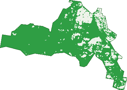
Green: 10 m cells where trees dominate, satellite 2021. Blue: water. The line is the suburb boundary.
| Canopy share, 1 m canopy height map, 2020 | 60.4% |
|---|---|
| Land with trees, 10 m satellite map, 2021 | 83.5% |
Demographics
Unemployment 4% · Labour-force participation 55.6%
Population by age in Tumbi Umbi
| 0-4 | 252 |
|---|---|
| 5-14 | 718 |
| 15-19 | 351 |
| 20-24 | 299 |
| 25-34 | 494 |
| 35-44 | 554 |
| 45-54 | 721 |
| 55-64 | 625 |
| 65-74 | 664 |
| 75-84 | 497 |
| 85+ | 200 |
Dwelling types in Tumbi Umbi
| House | 1,557 |
|---|---|
| Townhouse | 356 |
| Apartment | 4 |
| Other | 0 |
Households by weekly income in Tumbi Umbi
| <$650 | 302 |
|---|---|
| $650-1,499 | 545 |
| $1,500-2,999 | 520 |
| $3,000+ | 438 |
Top ancestries in Tumbi Umbi
| English | 2,361 |
|---|---|
| Australian | 2,225 |
| Irish | 695 |
| Scottish | 598 |
| Other | 320 |
| Aboriginal | 255 |
Housing tenure in Tumbi Umbi
| Owned | 674 |
|---|---|
| Mortgage | 749 |
| Rented | 292 |
| Other | 182 |
Cars per household in Tumbi Umbi
| 0 | 80 |
|---|---|
| 1 | 611 |
| 2 | 711 |
| 3 | 274 |
| 4+ | 215 |
Commute to work in Tumbi Umbi
| Car | 1,245 |
|---|---|
| Train | 6 |
| Bus | 3 |
| Tram/ferry | 0 |
| Walked | 20 |
| Bicycle | 6 |
| Home | 601 |
Top countries of birth in Tumbi Umbi
| England | 266 |
|---|---|
| New Zealand | 71 |
| South Africa | 34 |
| Scotland | 25 |
| Ireland | 23 |
| United States | 19 |
Languages used at home in Tumbi Umbi
| Spanish | 23 |
|---|---|
| Italian | 17 |
| Polish | 14 |
| Mandarin | 12 |
| French | 12 |
| Greek | 12 |
Birds & Wildlife Nearby
44,397 bird observations recorded near Tumbi Umbi — most often seen:
- Rainbow Lorikeet (3,497)
- Australian Magpie (2,290)
- Noisy Miner (2,046)
- Eastern Rainbow Lorikeet (1,820)
- Australian Pelican (1,777)
- Laughing Kookaburra (1,765)
- Chestnut Teal (1,748)
- Common Myna (1,738)
- Little Pied Cormorant (1,724)
- White-faced Heron (1,616)
- Coastal New South Wales Australian Magpie (1,588)
- Southern Noisy Miner (1,521)
- Bell Miner (1,427)
Show all 30 birds recorded near Tumbi Umbi
- Eastern Red Wattlebird (1,384)
- Southern Masked Lapwing (1,359)
- Magpie-lark (1,348)
- South-eastern Grey Butcherbird (1,325)
- Grey Butcherbird (1,262)
- Australasian Darter (1,251)
- Lewin's Honeyeater (1,188)
- Little Wattlebird (1,167)
- Great Egret (1,162)
- South-eastern Little Wattlebird (1,150)
- Southern Magpie-lark (1,141)
- Pacific Black Duck (1,090)
- Black Swan (1,063)
- Little Black Cormorant (1,057)
- Crested Pigeon (974)
- Striped Honeyeater (962)
- Masked Lapwing (957)
Sightings reported by observers, not a survey, so the counts show what people record rather than what lives here. Source: Atlas of Living Australia.
Nearby Suburbs
The closest suburbs to Tumbi Umbi:
- Killarney Vale (1.6 km)
- Berkeley Vale (2.9 km)
- Bateau Bay (3 km)
- Shelly Beach (3.7 km)
- Glenning Valley (3.7 km)
- Long Jetty (4.1 km)
- Forresters Beach (4.7 km)
- Chittaway Bay (4.7 km)
Embed this suburb
Add this free Tumbi Umbi stat card to your own site — just copy the code:
Preview:
Cite this page
Quoting these figures? Copy the credit line:
Keep an eye on Tumbi Umbi
One email when this data meaningfully changes — new census figures, prices, rankings. No spam, unsubscribe anytime.
Streets
- Adelaide Street (28)
- Albaha Lane (2)
- Alimah Close (4)
- Anderson Road (2)
- Bakali Road (13)
- Bangalow Close (16)
- Bates Close (4)
- Beaverdale Place (15)
- Beckingham Road (19)
- Bellevue Road (31)
- Benjamin Close (10)
- Bertram Road (11)
- Bligh Close (6)
- Blue Crane Close (39)
- Bohringer Lane (12)
- Brenda Crescent (49)
- Brush Road (5)
- Caralee Place (14)
- Carol Anne Close (17)
- Chappel Crescent (19)
- Coolong Close (7)
- Cutrock Road (6)
- Doran Place (42)
- Eastern Road (112)
- Eric Malouf Close (9)
- Felicia Close (9)
- Florence Avenue (19)
- Gordon Vaughan Road (3)
- Halloran Lane (9)
- Hamilton Street (28)
- Hansens Road (453)
- Harrison Place (8)
- Hayley Close (16)
- Hicks Lane (18)
- Highview Street (50)
- Hillside Drive (4)
- Holland Place (26)
- Immaculata Place (12)
- Jabiru Way (5)
- Jacana Close (20)
- Jaeger Road (68)
- Karena Street (9)
- Kenzie Lane (2)
- Kingfisher Place (8)
- Kyte Place (7)
- Lees Lane (4)
- Leetes Lane (18)
- Mackay Drive (34)
- Marilyn Crescent (26)
- Marlio Place (25)
- Mingara Drive (27)
- Minnow Close (7)
- Molsten Avenue (63)
- Morgan Avenue (64)
- Nangana Street (3)
- Northumberland Way (70)
- Palm Valley Road (62)
- Panarea Close (10)
- Park Lane (4)
- Peach Avenue (22)
- Pelican Street (25)
- Pescud Close (8)
- Peter Close (8)
- Pierre Close (9)
- Riley Close (6)
- Roberta Street (90)
- Sals Lane (12)
- Sandpiper Way (10)
- Scott Bruce Place (15)
- Shearwater Street (25)
- Sherlock Lane (20)
- Sherry Street (26)
- Stimsons Lane (30)
- Tanderra Road (1)
- Tattler Street (4)
- Tesoriero Terrace (13)
- The Avenue (25)
- The Ridgeway (20)
- Thornbill Grove (3)
- Tumbi Road (132)
- Victor Close (10)
- Warbler Way (7)
- Watson Avenue (38)
- Wendie Close (18)
- Wilum Close (7)
- Woodburys Lane (10)
- Woodstork Close (17)
- Wyong Road (99)