Taree NSW 2430
11,027 addresses · 313 streets
Lyne Electorate › Mid-Coast LGA › Taree · 248 km from Sydney
📦 Thinking of moving here? Read the Taree moving guide

Living Here
A regional centre on the Manning River on the NSW mid-north coast, Taree serves a rural district. Households average 2.2 people and the median age is 45. Median household income is $968 a week, and rent is very affordable at around $289.
Taree is a suburb of New South Wales, home to about 16,715 people, with a median age of 45. The typical household earns around $968 a week, with median rent near $289 a week. Most homes are houses. About 60% of households own their home and 38% rent. Most workers drive to work. Common community backgrounds include Australian, English, Aboriginal. On the ABS socio-economic scale it sits in decile 1 of 10 nationally — a more disadvantaged area.
Over time — Census 2001 → 2021
Dashed line: district figures for the Taree statistical area (SA2), the smallest area the ABS published before 2011. Solid line: Taree itself.
Getting Around & Local Services
4 cafés & restaurants
3 supermarkets
1 medical clinic
1 library
2 post offices
2 gyms & sports centres
1 golf club
1 butcher
3 hardware stores
Getting around. Train station: Taree, 500 m south · Airport: Taree Airport, 5.3 km east.
Socio-economic Standing
Deciles from 1 (lowest) to 10 (highest), against all Australian suburbs. The overall figure weighs advantage and disadvantage together; economic resources counts income and housing, and education & jobs counts qualifications and occupation. They often differ. Source: ABS SEIFA 2021.
Tree cover
🌳 Tree canopy: 28.8% share of land under canopy · satellite map, 2020
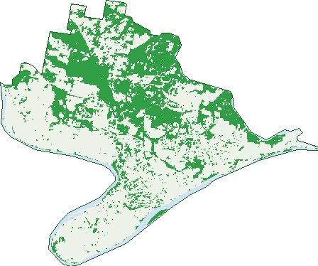
Green: 10 m cells where trees dominate, satellite 2021. Blue: water. The line is the suburb boundary.
| Canopy share, 1 m canopy height map, 2020 | 28.8% |
|---|---|
| Land with trees, 10 m satellite map, 2021 | 35.2% |
Demographics
Unemployment 9.3% · Labour-force participation 44.2%
Population by age in Taree
| 0-4 | 858 |
|---|---|
| 5-14 | 2,090 |
| 15-19 | 953 |
| 20-24 | 868 |
| 25-34 | 1,804 |
| 35-44 | 1,642 |
| 45-54 | 1,798 |
| 55-64 | 2,120 |
| 65-74 | 2,132 |
| 75-84 | 1,662 |
| 85+ | 776 |
Dwelling types in Taree
| House | 5,223 |
|---|---|
| Townhouse | 794 |
| Apartment | 643 |
| Other | 14 |
Households by weekly income in Taree
| <$650 | 1,872 |
|---|---|
| $650-1,499 | 2,441 |
| $1,500-2,999 | 1,406 |
| $3,000+ | 441 |
Top ancestries in Taree
| Australian | 6,952 |
|---|---|
| English | 6,799 |
| Aboriginal | 1,930 |
| Scottish | 1,562 |
| Irish | 1,508 |
| Ancestry NS | 1,458 |
Housing tenure in Taree
| Owned | 2,446 |
|---|---|
| Mortgage | 1,476 |
| Rented | 2,478 |
| Other | 98 |
Cars per household in Taree
| 0 | 702 |
|---|---|
| 1 | 2,944 |
| 2 | 1,939 |
| 3 | 611 |
| 4+ | 318 |
Commute to work in Taree
| Car | 4,209 |
|---|---|
| Train | 0 |
| Bus | 25 |
| Tram/ferry | 0 |
| Walked | 187 |
| Bicycle | 21 |
| Home | 278 |
Top countries of birth in Taree
| England | 326 |
|---|---|
| India | 142 |
| Philippines | 136 |
| New Zealand | 116 |
| Netherlands | 55 |
| Germany | 49 |
Languages used at home in Taree
| Malayalam | 92 |
|---|---|
| Mandarin | 53 |
| Filipino | 49 |
| Punjabi | 38 |
| Nepali | 37 |
| Arabic | 34 |
Birds & Wildlife Nearby
9,705 bird observations recorded near Taree — most often seen:
- Australian Magpie (742)
- Rainbow Lorikeet (686)
- Magpie-lark (559)
- Australian Wood Duck (462)
- Laughing Kookaburra (425)
- Australian Pelican (418)
- Masked Lapwing (375)
- Spotted Turtle-dove (369)
- Pacific Black Duck (350)
- Noisy Miner (345)
- Welcome Swallow (330)
- Willie Wagtail (322)
- Common Myna (307)
Show all 30 birds recorded near Taree
- Tawny Frogmouth (305)
- White-faced Heron (301)
- Black-faced Cuckoo-shrike (284)
- Crested Pigeon (253)
- Torresian Crow (252)
- Cattle Egret (246)
- Australian White Ibis (234)
- Eastern Rosella (234)
- Little Black Cormorant (230)
- Galah (229)
- Rock Dove (225)
- Scaly-breasted Lorikeet (219)
- House Sparrow (210)
- Pied Butcherbird (204)
- Common Starling (203)
- Australasian Figbird (201)
- Little Wattlebird (185)
Sightings reported by observers, not a survey, so the counts show what people record rather than what lives here. Source: Atlas of Living Australia.
Nearby Suburbs
The closest suburbs to Taree:
- Glenthorne (3.2 km)
- Taree South (4.1 km)
- Purfleet (4.6 km)
- Mondrook (4.8 km)
- Brimbin (4.8 km)
- Dumaresq Island (4.9 km)
- Cundletown (5.7 km)
- Tinonee (6.1 km)
Embed this suburb
Add this free Taree stat card to your own site — just copy the code:
Preview:
Cite this page
Quoting these figures? Copy the credit line:
Keep an eye on Taree
One email when this data meaningfully changes — new census figures, prices, rankings. No spam, unsubscribe anytime.
Streets
- Acacia Close (13)
- Alban Street (36)
- Albert Lane (19)
- Albert Street (215)
- Allambie Close (15)
- Allen Street (2)
- Allumba Close (27)
- Alonbar Crescent (16)
- Amaroo Drive (52)
- Andrew Close (23)
- Anita Close (22)
- Ann Street (17)
- Apollo Close (19)
- Arkwright Crescent (34)
- Arthur Avenue (30)
- Bahtoo Parade (41)
- Balmaringa Place (27)
- Bangalow Place (20)
- Banksia Place (3)
- Barton Street (35)
- Battinga Close (15)
- Bayview Crescent (76)
- Beeton Parade (47)
- Bent Street (21)
- Bettong Drive (11)
- Bilby Close (4)
- Blackbutt Place (8)
- Bligh Street (22)
- Boomerang Street (21)
- Boronia Avenue (7)
- Boyce Street (88)
- Bruntnell Street (93)
- Bundarra Close (10)
- Burrawong Crescent (24)
- Burri Street (20)
- Bushland Drive (212)
- Butea Drive (20)
- Butterworth Lane (1)
- Caesia Place (14)
- Campbell Street (26)
- Carbeen Close (13)
- Carina Close (12)
- Cedar Close (5)
- Cedar Party Road (66)
- Chapman Street (9)
- Chatham Avenue (111)
- Christie Street (17)
- Christina Close (7)
- Clare Place (6)
- Clifton Road (5)
- Coachwood Drive (8)
- Commerce Lane (18)
- Commerce Street (217)
- Cook Place (14)
- Coolabah Drive (77)
- Coorong Place (9)
- Cornwall Lane (23)
- Cornwall Street (127)
- Cottonwood Street (13)
- Coulston Street (29)
- Court Place (10)
- Cowan Road (52)
- Cowper Street (189)
- Craiglea Close (11)
- Crescent Avenue (62)
- Dale Street (11)
- Davis Street (13)
- Deakin Crescent (34)
- Deb Street (39)
- Denva Bird Way (15)
- Denver Bird Way (15)
- Dolphin Avenue (68)
- Donald Avenue (9)
- Douglas Street (16)
- Dugdale Avenue (32)
- Dunoon Street (44)
- Duranbar Place (21)
- Dyballs Lane (15)
- Edinburgh Drive (217)
- Elata Court (9)
- Elizabeth Avenue (36)
- Eric Street (49)
- Euroka Road (9)
- Evaron Drive (5)
- Fadden Close (10)
- Failford Road (1)
- Fairway Lane (3)
- Fallow Drive (11)
- Ferry Road (21)
- Fisher Street (37)
- Flametree Close (20)
- Flett Street (115)
- Flinders Street (31)
- Florence Street (92)
- Forest Grove (19)
- Fotheringham Street (41)
- Frances Lane (6)
- Frances Street (92)
- Fuchsia Drive (50)
- Georges Lane (32)
- Gill Avenue (72)
- Gipps Street (34)
- Gleeson Crescent (23)
- Gleneagle Street (25)
- Glenhaven Street (17)
- Golf Avenue (36)
- Grandis Parade (32)
- Gregory Close (10)
- Grevillea Close (12)
- Grey Gum Road (60)
- Gunbar Road (46)
- Gwenneth Avenue (19)
- Hakea Close (8)
- Hallstrom Avenue (4)
- Hargreaves Drive (41)
- Hayes Lane (10)
- Henry Flett Street (49)
- Hibiscus Close (15)
- Hickory Crescent (67)
- High Street (232)
- Hilda Close (6)
- Hillcrest Close (9)
- Hinten Crescent (23)
- Honeysuckle Close (10)
- Hooke Street (39)
- Hughes Street (27)
- Hyperno Close (8)
- Illingari Circuit (45)
- Iluka Circuit (90)
- Inala Close (7)
- Irkanda Drive (9)
- Ironbark Close (4)
- Jacaranda Avenue (58)
- Japonica Road (15)
- Jarrah Place (18)
- Jaydee Chase (7)
- John Armstrong Close (21)
- John Hall Drive (28)
- John Street (3)
- Joseph Andrews Crescent (31)
- Julia View (3)
- Kalimna Close (13)
- Kanangra Drive (104)
- Kathryn Place (6)
- Kauri Close (4)
- Kennedy Street (18)
- Kentia Close (11)
- Kerle Street (8)
- Killawarra Drive (60)
- Kindabel Close (1)
- King Valley Drive (57)
- Kolodong Road (84)
- Kristanne Close (8)
- Kurrajong Crescent (54)
- Lakkari Close (35)
- Landina Close (8)
- Latham Avenue (39)
- Lawson Crescent (39)
- Leigh Drive (5)
- Levicks Lane (4)
- Lilac Close (13)
- Link Street (2)
- Little Wynter Street (29)
- Louis Street (29)
- Lyndhurst Street (23)
- Mackay Street (48)
- Macquarie Street (44)
- Magnolia Crescent (13)
- Mahogany Crescent (11)
- Maiden Avenue (30)
- Malus Crescent (9)
- Manikato Place (64)
- Manning Point Road (3)
- Manning River Drive (76)
- Manning Street (299)
- Marathon Street (10)
- Marie Avenue (115)
- Marjorie Street (25)
- Marsden Terrace (28)
- Mason Close (8)
- Mawarra Place (7)
- Mclaughlin Avenue (14)
- Mclennan Street (16)
- Mcleod Close (5)
- Mcrae Avenue (25)
- Melaleuca Place (28)
- Melinga Place (14)
- Mill Close (12)
- Milligan Street (77)
- Montgomery Crescent (3)
- Mudford Street (75)
- Muldoon Street (113)
- Munghi Close (1)
- Myall Avenue (36)
- Nagle Close (20)
- Napunyah Drive (20)
- Narla Place (17)
- Narran Place (6)
- Neals Lane (8)
- Nelson Street (10)
- Nicoll Crescent (20)
- Nicoll Street (26)
- Nimoola Drive (3)
- Nioka Place (8)
- North Street (5)
- Ochiltree Place (13)
- Oleander Close (14)
- Olympia Street (10)
- Omaru Crescent (19)
- Orana Crescent (33)
- Orchid Close (11)
- Oxley Street (106)
- Pacific Highway (29)
- Page Street (11)
- Palanas Drive (51)
- Park Lane (4)
- Park Street (5)
- Parraweena Road (2)
- Paruna Close (8)
- Patanga Close (24)
- Patricia Avenue (18)
- Pepper Tree Way (3)
- Petken Drive (61)
- Pettitt Avenue (20)
- Phillip Street (3)
- Pindari Crescent (29)
- Pioneer Street (30)
- Pitt Street (65)
- Plover Street (46)
- Plummer Street (42)
- Possum Brush Road (2)
- Potoroo Drive (44)
- Pulteney Street (192)
- Putta Road (4)
- Pyrus Drive (25)
- Queen Street (11)
- Racecourse Drive (3)
- Rachel Close (6)
- Railton Avenue (8)
- Railway Parade (54)
- Railway Street (19)
- Richardson Street (34)
- Rifle Range Road (9)
- Ritchie Crescent (70)
- River Street (51)
- Riverlinks Court (22)
- Robertson Street (31)
- Robusta Parade (25)
- Rohini Place (18)
- Ronald Road (67)
- Rosebank Avenue (23)
- Rosewood Crescent (44)
- Ruby Drive (18)
- Samantha Close (19)
- Samba Way (1)
- Shaybisc Close (12)
- Short Street (38)
- Sienna Place (6)
- Smith Street (59)
- Sorrento Place (21)
- Spence Street (123)
- St Josephs Drive (1)
- St Vincent Street (17)
- Stacey Drive (15)
- Stevenson Lane (20)
- Stevenson Street (81)
- Stewart Street (42)
- Stirling Place (17)
- Stitts Close (5)
- Stokes Circuit (71)
- Strathmore Place (10)
- Sturt Place (17)
- Sundara Close (18)
- Talawong Drive (82)
- Tarrumbi Way (11)
- Tasman Street (5)
- Tecoma Court (3)
- Telopea Drive (36)
- Templetons Lane (3)
- Timbarra Close (16)
- Toona Close (9)
- Tristania Crescent (33)
- Uki Place (12)
- Urara Lane (17)
- Valerie Street (36)
- Veronica Street (15)
- Victor Close (4)
- Victoria Street (654)
- Wandarra Street (33)
- Waratah Place (7)
- Warrina Close (27)
- Warwiba Road (4)
- Wattle Close (8)
- Wells Street (42)
- Wentworth Street (32)
- West End Avenue (24)
- Whitbread Street (72)
- Whitby Close (14)
- Wilga Street (23)
- Willow Close (9)