Stroud NSW 2425
727 addresses · 51 streets
Lyne Electorate › Mid-Coast LGA › Stroud · 178 km from Sydney
📦 Thinking of moving here? Read the Stroud moving guide

Living Here
Stroud is a suburb of New South Wales, home to about 988 people, with a median age of 48. The typical household earns around $1,310 a week, with median rent near $320 a week. Most homes are houses. About 82% of households own their home and 14% rent. Most workers drive to work. Common community backgrounds include Australian, English, Irish. On the ABS socio-economic scale it sits in decile 4 of 10 nationally — a mid-range area.
Over time — Census 2001 → 2021
Dashed line: district figures for the Bulahdelah - Stroud statistical area (SA2), the smallest area the ABS published before 2011. Solid line: Stroud itself.
Getting Around & Local Services
1 school
2 cafés & restaurants
1 supermarket
3 parks
1 pharmacy
1 library
1 post office
1 butcher
Getting around. Airport: RAAF Base Williamtown, 45.4 km south.
Socio-economic Standing
Deciles from 1 (lowest) to 10 (highest), against all Australian suburbs. The overall figure weighs advantage and disadvantage together; economic resources counts income and housing, and education & jobs counts qualifications and occupation. They often differ. Source: ABS SEIFA 2021.
Tree cover
🌳 Tree canopy: 73.3% share of land under canopy · satellite map, 2020
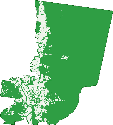
Green: 10 m cells where trees dominate, satellite 2021. Blue: water. The line is the suburb boundary.
| Canopy share, 1 m canopy height map, 2020 | 73.3% |
|---|---|
| Land with trees, 10 m satellite map, 2021 | 83.5% |
Demographics
Unemployment 3.9% · Labour-force participation 54.1%
Population by age in Stroud
| 0-4 | 54 |
|---|---|
| 5-14 | 123 |
| 15-19 | 51 |
| 20-24 | 46 |
| 25-34 | 97 |
| 35-44 | 85 |
| 45-54 | 121 |
| 55-64 | 147 |
| 65-74 | 135 |
| 75-84 | 88 |
| 85+ | 37 |
Dwelling types in Stroud
| House | 352 |
|---|---|
| Townhouse | 3 |
| Apartment | 0 |
| Other | 3 |
Households by weekly income in Stroud
| <$650 | 67 |
|---|---|
| $650-1,499 | 118 |
| $1,500-2,999 | 96 |
| $3,000+ | 53 |
Top ancestries in Stroud
| Australian | 465 |
|---|---|
| English | 456 |
| Irish | 114 |
| Scottish | 101 |
| Ancestry NS | 74 |
| Aboriginal | 52 |
Housing tenure in Stroud
| Owned | 153 |
|---|---|
| Mortgage | 136 |
| Rented | 49 |
| Other | 14 |
Cars per household in Stroud
| 0 | 8 |
|---|---|
| 1 | 104 |
| 2 | 143 |
| 3 | 60 |
| 4+ | 37 |
Commute to work in Stroud
| Car | 234 |
|---|---|
| Train | 0 |
| Bus | 0 |
| Tram/ferry | 0 |
| Walked | 17 |
| Bicycle | 0 |
| Home | 93 |
Top countries of birth in Stroud
| England | 35 |
|---|---|
| New Zealand | 13 |
| Canada | 7 |
| Scotland | 4 |
| Philippines | 3 |
Languages used at home in Stroud
| Punjabi | 6 |
|---|
Birds & Wildlife Nearby
2,158 bird observations recorded near Stroud — most often seen:
- Southern Lewin's Honeyeater (173)
- South-eastern Yellow-faced Honeyeater (138)
- Tasmanian Grey Fantail (127)
- South-eastern White-throated Treecreeper (125)
- Eastern Golden Whistler (110)
- South-eastern Yellow Robin (91)
- South-eastern Brown Thornbill (86)
- Coastal New South Wales Australian Magpie (83)
- Southern Brown Gerygone (78)
- Northern Superb Fairy-wren (76)
- South-east Eastern Whipbird (75)
- Southern Laughing Kookaburra (73)
- Coastal Spotted Pardalote (67)
Show all 30 birds recorded near Stroud
- Eastern Grey Shrike-thrush (66)
- Laughing Kookaburra (66)
- White-headed Pigeon (61)
- Southern Noisy Friarbird (59)
- South-east Eastern Spinebill (56)
- Australian Wood Duck (55)
- Common Myna (55)
- South-eastern Silvereye (55)
- Australian Magpie (49)
- Eastern Australian Raven (44)
- Eastern Welcome Swallow (42)
- Galah (42)
- Mainland Black-faced Cuckoo-shrike (42)
- Magpie-lark (41)
- Southern Australian King-parrot (41)
- Southern Masked Lapwing (41)
- Southern Willie Wagtail (41)
Sightings reported by observers, not a survey, so the counts show what people record rather than what lives here. Source: Atlas of Living Australia.
Nearby Suburbs
The closest suburbs to Stroud:
- Washpool (5.4 km)
- Stroud Road (7.3 km)
- Nooroo (8 km)
- Booral (8.7 km)
- Girvan (12.4 km)
- Cambra (12.7 km)
- Stroud Hill (15 km)
- Allworth (15.7 km)
Embed this suburb
Add this free Stroud stat card to your own site — just copy the code:
Preview:
Cite this page
Quoting these figures? Copy the credit line:
Keep an eye on Stroud
One email when this data meaningfully changes — new census figures, prices, rankings. No spam, unsubscribe anytime.
Streets
- Avon Street (18)
- Bede Street (18)
- Berkeley Street (59)
- Booral-washpool Road (13)
- Bridge Street (7)
- Briton Court Road (55)
- Broadway Street (18)
- Bromeliad Street (1)
- Church Lane (2)
- Church Street (15)
- Coppermine Creek Road (7)
- Cowper Street (111)
- Dawson Street (1)
- Dungog Road (3)
- Erin Street (24)
- Farrells Road (3)
- Gamack Street (4)
- Gidley Street (11)
- Gloucester Street (10)
- Gortons Crossing Road (7)
- Greenhams Lane (1)
- Griffin Street (5)
- Hinton Street (10)
- Hodgson Street (3)
- John Street (1)
- King Street (19)
- Lady Parry Drive (3)
- Laman Street (12)
- Lowrey Street (19)
- Mallon Street (16)
- Memorial Avenue (54)
- Mill Creek Road (53)
- Millbrook Road (11)
- Mitchell Street (5)
- Nairn Street (1)
- Nicholls Street (24)
- Ribbons Road (5)
- Saggers Creek Road (8)
- Saville Street (11)
- Scotia Street (5)
- Shaw Street (8)
- Simmsville Road (21)
- Spencer Street (6)
- St Clairs Road (1)
- Stoney Creek Road (4)
- Stroud Hill Road (1)
- The Bucketts Way (15)
- Thompsons Lane (7)
- Urquharts Lane (2)
- Watergum Lane (2)
- Wye Street (7)